Nzega District is one of the seven districts of the Tabora Region of Tanzania. It is bordered to the north by Shinyanga Region, to the south and southwest by Uyui District and to the east by Igunga District. Its administrative seat is the town of Nzega.
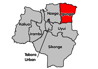
Igunga is one of the seven districts of the Tabora Region of Tanzania. It is bordered to the north by the Shinyanga Region, to the east by the Singida Region, to the south by the Uyui District and to the west by the Nzega District. Its administrative seat is the town of Igunga. Igunga is now divided by two Constituencys: Igunga Constituency and Manonga Constituency, whereby Manonga town is Choma Chankola. Igunga is the second district in production

Rungwe is a district in Mbeya Region, Tanzania. It is bordered to the north by Mbeya Rural District, to the east by Iringa Region, to the southeast by Kyela District, to the southwest by Ileje District and to the west by Mbeya District.
Kapalala is an administrative ward in Songwe District, Songwe Region, Tanzania. According to the 2002 census, the ward has a total population of 5,924.
Katumba is an administrative ward in the Rungwe District of the Mbeya Region of Tanzania. According to the 2002 census, the ward has a total population of 10,965.
Nkunga is an administrative ward in the Rungwe district of the Mbeya Region of Tanzania. According to the 2002 census, the ward has a total population of 14,685.
Bupigu is an administrative ward in Ileje District, Songwe Region, Tanzania. According to the 2002 census, the ward has a total population of 6,190.
Ibaba is an administrative ward in Ileje District, Songwe Region, Tanzania. In the 2002 census, the ward had a total population of 6,805. Ibaba is composed of five village which are Lali, Sheyo, Shikunga, Shuba and Ibaba itself.
Ikinga is an administrative ward in Ileje District, Songwe Region, Tanzania. According to the 2002 census, the ward had a total population of 7,114.

Itumba is an administrative ward in Ileje District, Songwe Region, Tanzania. According to the 2002 census, the ward has a total population of 12,668. It is home to the Ndali people, who occupy that region of Tanzania and parts of Malawi.
Kafule is an administrative ward in Ileje District, Songwe Region, Tanzania. According to the 2002 census, the ward has a total population of 6,892.
Lubanda is an administrative ward in Ileje District, Songwe Region, Tanzania. According to the 2002 census, the ward has a total population of 7,952.
Luswisi is an administrative ward in Ileje District, Mbeya Region, Tanzania. According to the 2002 census, the ward has a total population of 4,790.
Ngulilo is an administrative ward in Ileje District, Mbeya Region, Tanzania. According to the 2002 census, the ward has a total population of 3,820. The official language is Swahili, and much of the population does not know how to speak English.
Ngulugulu is an administrative ward in Ileje District, Songwe Region, Tanzania. According to the 2002 census, the ward has a total population of 5,346.
Sange is an administrative ward in Ileje District, Songwe Region, Tanzania. According to the 2002 census, the ward has a total population of 4,396.
Sejeli is an administrative ward in the Kongwa district of the Dodoma Region of Tanzania. According to the 2002 census, the ward has a total population of 12,242.
Wangama is a town and ward in Wanging'ombe District in the Njombe Region of the Tanzanian Southern Highlands. The population of the ward, according to the 2002 Tanzanian census, was 3,649.
Suma is an administrative ward in Rungwe District, Mbeya Region, Tanzania. As of 2002, the ward had a total population of 11,448.
Itale is an administrative ward in Ileje District, Songwe Region, Tanzania. According to the 2012 census, the ward has a total population of 7,609, up from 6,720 in 2002.
