Related Research Articles

The R61 is a long provincial route in South Africa that connects Beaufort West with Port Shepstone via Graaff-Reinet, Komani, Mthatha and Port Edward.

The N2 is a national route in South Africa that runs from Cape Town through George, Gqeberha, East London, Mthatha, Port Shepstone and Durban to Ermelo. It is the main highway along the Indian Ocean coast of the country. Its current length of 2,255 kilometres (1,401 mi) makes it the longest numbered route in South Africa.

Mthatha ; Xhosa:[ḿ̩ˈtʰâːtʰà], alternatively rendered Umtata, is the main city of the King Sabata Dalindyebo Local Municipality in Eastern Cape province of South Africa and the capital of OR Tambo District Municipality. The city has an airport, previously known as the K. D. Matanzima Airport after former leader Kaiser Matanzima. Mthatha derives its name from the nearby Mthatha River which was named after the sneezewood (umtati) trees, famous for their wood and medicinal properties.
Qunu is a Xhosa rural village in South Africa's Eastern Cape Province, 32 km (20 mi) south-west of Mthatha on the N2 national route.

The Chris Hani District Municipality is a landlocked district municipality situated in the centre of the Eastern Cape province of South Africa and is made up of eight local municipalities. Most of the communities are in rural areas. The landscape ranges from moist uplands and grassland hills to the arid Karoo scrubland.
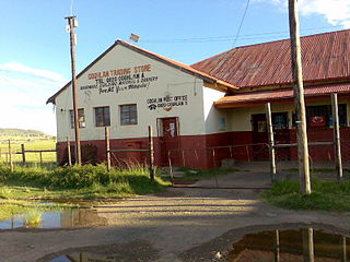
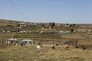
Coghlan is a small South African village in the Eastern Cape on the road between Ngcobo and Mthatha and due north from Xuka Drift on the Xuka River. The Xuka River and the Xinika River are the two main tributaries of the Mbashe River.
Mthatha Airport is an airport serving Mthatha, a city in the Eastern Cape province of South Africa. The airport was previously named K. D. Matanzima Airport after Kaiser Matanzima, a president of the former Transkei.
The Diocese of Mthatha is a diocese of the Anglican Church of Southern Africa in the Eastern Cape province of South Africa. Before 2006 it was known as the Diocese of St John's, and earlier still as that of Kaffraria. The diocese currently has 96 parishes.
Mzimvubu to Keiskamma WMA, or Mzimvubu to Keiskamma Water Management Area , includes the following major rivers: the Swane River, Mntafufu River, Mzimvubu River, Mngazi River, Mthatha River, Xora River, Mbashe River, Nqabara River, Gqunube River, Buffalo River, Nahoon River, Groot Kei River and Keiskamma River, and covers the following Dams:

Woodhead Dam is a dam on Table Mountain, Western Cape, South Africa. It was built in 1897 and supplies water to Cape Town. The dam, which was the first large masonry dam in South Africa, was designated as an International Historic Civil Engineering Landmark by the American Society of Civil Engineers in 2008.

The Crocodile River is a river in South Africa. At its confluence with the Marico River, the Limpopo River is formed.
The Vaal River Barrage Reservoir is a dam on the Vaal River near Vanderbijlpark, border Gauteng and Free State, South Africa.

King Sabata Dalindyebo Municipality is a local municipality situated in the inland of the Eastern Cape province of South Africa. The municipality includes the towns of Mthatha and Mqanduli. The King Sabata Dalindyebo Municipality is one of the seven local municipalities within the OR Tambo District Municipality.

Coffee Bay is a town on the Wild Coast of the Eastern Cape Province of South Africa. It is located about 250 kilometres south-west of the city of Durban and has a population of 258 people.

Port St. Johns is a town of about 6,500 people on the Wild Coast in the Eastern Cape province of South Africa. It is situated at the mouth of the Umzimvubu River, 220 kilometres (140 mi) northeast of East London and 70 kilometres (40 mi) east of Mthatha. Port St. Johns was the birthplace of Capital Radio 604.
Mthatha River or Umtata River is a river in the Eastern Cape Province in South Africa. The river flows into the Indian Ocean in an estuary located near Coffee Bay. The Mthatha river flows in a southeastern direction and is approximately 250 km long with a catchment area of 2,600 km2. Mthatha Town (Umtata) is named after it.
All Saints Hospital is a Provincial government funded hospital in Ngcobo, Eastern Cape in South Africa. Situated in Ngcobo, around 80km from Mthatha, the hospital serves the entire Ngcobo and some of the Cofimvaba community of over 148 000 people.

Mandisa Muriel Lindelwa Maya Mlokoti is the first female South African Deputy Chief Justice. She is also the first female jurist who has served as President of the Supreme Court of Appeal of South Africa (SCA) since 26 May 2017 until 31 August 2022 and the first female chancellor of University of Mpumalanga since 1 July 2021. She had previously served as a judge in the Mthatha High Court, as a puisne judge of the SCA and as Deputy President of the SCA, as well as holding acting positions in various courts.
References
| Authority control databases: Geographic |
|---|
This article about a dam or floodgate in South Africa is a stub. You can help Wikipedia by expanding it. |