History
One of the earliest Tai principalities in Laos was centered at Muang Ngoi. By the 12th century AD there were settlements in the area that were part of a chain of Tai Mueangs along the Nam Ou River. The current town dates from the 15th century and is the old district capital.
In 1713 Chao Intasom, son of the first king of Luang Prabang, halted his army in Muang Ngoi to prepare for an attack on his nephew Chao Ong Kham, who succeeded the king. It was here that the two nephews came to an agreement and decided to share the throne together.
In 1892, shortly before the incorporation of Laos into French Indochina, there was a military station with 25 soldiers which served as a frontier post of Siam.
During the Laotian Civil War, Pathet Lao forces were stationed in a cave near Muang Ngoi. The town was uninhabitable for over 2 years due to the threat of bombing raids by the Royal Laotian Air Force, forcing hundreds of villagers to relocate to a nearby cave.

Evidence of modern human presence in the northern and central highlands of Indochina, which constitute the territories of the modern Laotian nation-state, dates back to the Lower Paleolithic. These earliest human migrants are Australo-Melanesians—associated with the Hoabinhian culture—and have populated the highlands and the interior, less accessible regions of Laos and all of Southeast Asia to this day. The subsequent Austroasiatic and Austronesian marine migration waves affected landlocked Laos only marginally, and direct Chinese and Indian cultural contact had a greater impact on the country.

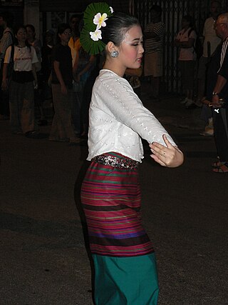
The Lao people are a Tai ethnic group native to Southeast Asia, who speak the Lao language of the Kra–Dai languages. They are the majority ethnic group of Laos, making up 53.2% of the total population. The majority of Lao people adhere to Theravada Buddhism. They are closely related to other Tai people, especially with the Isan people, who are also speakers of Lao language, native to neighboring Thailand.

Lan Xang or Lancang was a Lao kingdom that held the area of present-day Laos from 1353 to 1707. For three and a half centuries, Lan Xang was one of the largest kingdoms in Southeast Asia. The kingdom is the basis for Laos's national historic and cultural identity.

Luang Phabang, or Louangphabang, commonly transliterated into Western languages from the pre-1975 Lao spelling ຫຼວງພຣະບາງ as Luang Prabang, literally meaning "Royal Buddha Image", is a city in north central Laos, consisting of 58 adjacent villages, of which 33 comprise the UNESCO Town of Luang Prabang World Heritage Site. It was listed in 1995 for unique and "remarkably" well preserved architectural, religious and cultural heritage, a blend of the rural and urban developments over several centuries, including the French colonial influences during the 19th and 20th centuries.

Muang Phuan or Xieng Khouang, also known historically to the Vietnamese as Trấn Ninh, was a historical principality on the Xiang Khouang Plateau, which constitutes the modern territory of Xiangkhouang Province, Laos.
The Northern Thai people or Tai Yuan, self-designation khon mu(e)ang are a Tai ethnic group, native to nine provinces in Northern Thailand, principally in the area of the former kingdom of Lan Na. As a Tai group, they are closely related to Tai Lü and Tai Khün with regards to common culture, language and history as well as to Thailand's dominant Thai ethnic group. There are approximately 6 million Tai Yuan. Most of them live in Northern Thailand, with a small minority 29,442 living across the border in Bokeo Province of Laos. Their language is called Northern Thai, Lanna or Kham Mueang.

Xam Neua, is the capital of Houaphanh Province, Laos, in northeast Laos.

The Haw Wars were fought against Chinese quasi-military refugee gangs invading parts of Tonkin and the Siam from 1865–1890. Forces invading Lao domains were ill-disciplined and freely demolished Buddhist temples. Not knowing these were remnants of secret societies, the invaders were wrongly called Haw. Forces sent by King Rama V failed to suppress the various groups, the last of which eventually disbanded in 1890.

The Lao Rebellion of 1826–1828 was an attempt by King Anouvong of the Kingdom of Vientiane to end the suzerainty of Siam and recreate the former kingdom of Lan Xang. In January 1827 the Lao armies of the kingdoms of Vientiane and Champasak moved south and west across the Khorat Plateau, advancing as far as Saraburi, just three days march from the Siamese capital of Bangkok. The Siamese mounted a counterattack to the north and east, forcing the Lao forces to retreat and ultimately taking the capital of Vientiane. Anouvong failed in both his attempt to resist Siamese encroachment, and to check the further political fragmentation among the Lao. The kingdom of Vientiane was abolished, its population was forcibly moved to Siam, and its former territories fell under the direct control of Siamese provincial administration. The kingdoms of Champasak and Lan Na were drawn more closely into the Siamese administrative system. The kingdom of Luang Prabang was weakened but allowed the most regional autonomy. In its expansion into the Lao states, Siam overextended itself. The rebellion was a direct cause of the Siamese-Vietnamese wars in the 1830s and 1840s. The slave raids and forced population transfers conducted by Siam led to a demographic disparity between the areas that would ultimately become Thailand and Laos, and facilitated the "civilizing mission" of the French into Lao areas during the latter half of the nineteenth century.

Tai Nüa is one of the Tai ethnicities in South East Asia. They are mostly found in the Yunnan Province of China, Laos, Thailand, Burma and Vietnam and some have emigrated to the United States of America. There are however two different groups of Tai people called Tai Nua, one in China and Burma, the other in Laos.

The Southwestern Tai or Thailanguages are a branch of the Tai languages of Southeast Asia. Its languages include Central Thai (Siamese), Northern Thai (Lanna), Lao, Shan and others.

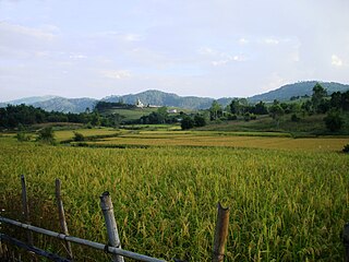
Muang Sing is a small town and district (muang) in Luang Namtha Province, northwestern Laos, about 60 kilometres northwest of the town of Luang Namtha and 360 kilometres northwest of Vientiane. It lies very close to the border with Yunnan, China, surrounded by mountains and rivers. Historically, Muang Sing has been a major producer of opium and still has problems with drugs and smuggling, due to its proximity to China and Myanmar.
Xiangkhouang is a province of Laos on the Xiangkhoang Plateau, in the nation's northeast. The province has the distinction of being the most heavily-bombed place on Earth.

Houaphanh province is a province in eastern Laos. Its capital is Xam Neua.
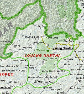
Luang Namtha is a province of Laos in the country's north. From 1966 to 1976 it formed, together with Bokeo, the province of Houakhong. Luang Namtha province covers an area of 9,325 square kilometres (3,600 sq mi). Its provincial capital is Luang Namtha. The province borders Yunnan, China to the north, Oudomxai province to the east and southeast, Bokeo province to the southwest, and Shan State, Myanmar to the northwest.

Sainyabuli province is a province in northwest Laos. Saiyabuli town is the capital of the province. Saiyabuli is the only Lao province that is completely west of the Mekong River.

Phongsaly province, also spelled Phôngsali, is a province of Laos in the extreme north of the country. The capital of the province is the city of Phôngsali. Phongsaly is between Yunnan (China), and Điện Biên province in Vietnam. Its culture has thus been historically heavily influenced by China.

Luang Prabang is a province in northern Laos. Its capital of the same name, Luang Prabang, was the capital of the Lan Xang Kingdom during the 13th to 16th centuries. It is listed since 1995 by UNESCO as a World Heritage Site for unique architectural, religious and cultural heritage, a blend of the rural and urban developments over several centuries, including the French colonial influences during the 19th and 20th centuries. The province has 12 districts. The Royal Palace, the national museum in the capital city, and the Phou Loei Protected Reserve are important sites. Notable temples in the province are the Wat Xieng Thong, Wat Wisunarat, Wat Sen, Wat Xieng Muan, and Wat Manorom. The Lao New Year is celebrated in April as The Bun Pi Mai.

