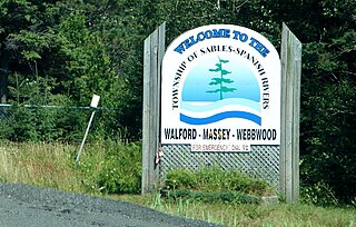
Sables-Spanish Rivers is a township in Ontario, Canada, on the north shore of Georgian Bay. It is located in the Sudbury District, approximately 70 kilometres (43 mi) west of Sudbury.

North Toronto is a former town and informal district located in the northern part of the Old Toronto district in Toronto, Ontario, Canada. Currently occupying a geographically central location within the city of Toronto, the Town of North Toronto was incorporated in 1890, when much of the area was still farmland, and annexed by the old city of Toronto in 1912. The name is still used to refer to the area in general, although Yonge–Eglinton and Midtown Toronto are officially used.

Fiumicino is a town and comune in the Metropolitan City of Rome, Lazio, central Italy, with a population of 80,500 (2019). It is known for being the site of Leonardo da Vinci–Fiumicino Airport, the busiest airport in Italy and the eleventh-busiest in Europe.
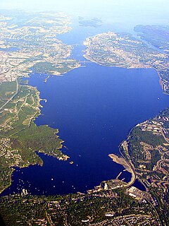
Bedford Basin is a large enclosed bay, forming the northwestern end of Halifax Harbour on Canada's Atlantic coast. It is named in honour of John Russell, 4th Duke of Bedford.
Dorchester is a village and shire town in Westmorland County, New Brunswick, Canada. It is named for Guy Carleton, 1st Baron Dorchester, an 18th-century Governor-General of the old Province of Quebec.

The St. Lawrence and Atlantic Railroad, known as St-Laurent et Atlantique Quebec in Canada, is a short-line railway operating between Portland, Maine, on the Atlantic Ocean, and Montreal, Quebec, on the St. Lawrence River. It crosses the Canada–US border at Norton, Vermont, and Stanhope, Quebec, and is owned by short-line operator Genesee & Wyoming.

The Canadian is a transcontinental passenger train operated by Via Rail with service between Union Station in Toronto, Ontario and Pacific Central Station in Vancouver, British Columbia, Canada.

Gillam is a town on the Nelson River in northern Manitoba, Canada. It is situated between Thompson and Churchill on the Hudson Bay Railway line.

Dudhsagar Falls is a four-tiered waterfall located on the Mandovi River in the Indian state of Goa. It is 60 km from Panaji by road and is located on the Belgavi–Vasco Da Gama rail route about 46 km east of Madgaon and 80 km south of Belgavi. Dudhsagar Falls is amongst India's tallest waterfalls with a height of 310 m (1017 feet) and an average width of 30 metres (100 feet).

The River Colne is a small river that runs through Essex, England and passes through Colchester. It is not a tributary of any other river, instead having an estuary that joins the sea near Brightlingsea. The river's name is of Celtic origin, combining the word for rock "cal" with a remnant of the word "afon", or river, giving the meaning "stony river". There are two other rivers in the UK that share the same name.

Entwistle is a hamlet in Alberta, Canada within Parkland County. It is located at the Yellowhead Highway's intersection with Highway 22/Highway 16A, approximately 95 kilometres (59 mi) west of Edmonton. Entwistle sits on the east banks of the Pembina River near the halfway point between Edmonton and Edson.

Hastings Highlands is a township in the Canadian province of Ontario.

The North Thompson River is the northern branch of the Thompson River, the largest tributary of the Fraser River, in the Canadian province of British Columbia. It originates at the toe of the Thompson Glacier in the Premier Range of the Cariboo Mountains, west of the community of Valemount. The river flows generally south through the Shuswap Highland towards Kamloops where it joins the South Thompson River to form the main stem Thompson River.

Kemptville Creek is a stream in the municipalities of North Grenville and Augusta, in the United Counties of Leeds and Grenville, in Eastern Ontario, Canada. It is in the Ottawa River drainage basin, is a right tributary of the Rideau River, and is under the auspices of the Rideau Valley Conservation Authority.
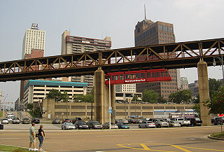
The Memphis Suspension Railway or Mud Island Monorail is a suspended monorail that connects the city center of Memphis with the entertainment park on Mud Island. Celebrating its grand opening on July 3, 1982, it is located beneath a footbridge over the Wolf River Lagoon connecting to the southern tip of Mud Island.

Highway 35 is a paved undivided provincial highway in the Canadian province of Saskatchewan. It runs from the US Border near Port of Oungre to a dead end near the north shore of Tobin Lake. Saskatchewan Highway 35 (SK Hwy 35) is about 569 kilometres (354 mi) long. The CanAm Highway comprises Saskatchewan Highways 35, SK Hwy 39, SK Hwy 6, SK Hwy 3, SK Hwy 2 and U.S. Route 85. 74.6 kilometres (46.4 mi) of SK Hwy 35 contribute to the CanAm Highway between Port of Oungre on the Canada – United States border and Weyburn. Mudslides, and spring flooding were huge road building and maintenance problems around Nipawin as well as along the southern portion of the route named the Greater Yellow Grass Marsh. Over 20 early dams were built until the problem was addressed with the Rafferty-Alameda Project on the Souris River and the construction of the Qu'Appelle River Dam which have helped to eliminate washed out roads and flooded communities. The highway through the homesteading community followed the Dominion Land Survey on the square until reaching the Saskatchewan River at Nipawin. The completion of the combined railway and traffic bridge over the Saskatchewan River at Nipawin in the late 1920s retired the ferry and basket crossing for traffic north of Nipawin. The E.B. Campbell Dam built in 1963 northeast of Nipawin created Tobin Lake, and Codette Lake was formed with the construction of the Francois-Finlay Hydroelectric dam at Nipawin. The railway/traffic bridge that formed part of Highway 35 was the only crossing utilized at Nipawin until a new traffic bridge was constructed in 1974. The new bridge then became part of the combined Highway 35 and 55 until the highway parts just east of White Fox. Highway 35 then continued north along the west side of Tobin Lake. The railway/traffic bridge continues to be utilized for one lane vehicle traffic controlled by traffic lights, and continues as the "old highway 35" on the west side of the river until it joins with the current Highway 35/55.
Blue River is a small community in British Columbia, situated on British Columbia Highway 5 about halfway between Kamloops and Jasper, Alberta, located at the confluence of the Blue and North Thompson Rivers. The local economy is supported by logging, tourism and transportation industries.

Watino is a hamlet in northern Alberta, Canada within Birch Hills County. It is located on Highway 49, approximately 96 kilometres (60 mi) northeast of Grande Prairie, and has an elevation of 385 meters (1,263 ft).

This is the outline of the geography of the city of Ottawa, the capital of Canada. Ottawa's current borders were formed in 2001, when the former city of Ottawa amalgamated with the ten other municipalities within the former Regional Municipality of Ottawa–Carleton. Ottawa is now a single-tiered census division, home to 870,250 people.
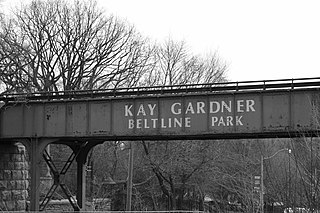
The Beltline Trail is a 9-kilometre (5.6 mi)-long cycling and walking rail trail in Toronto, Ontario, Canada. It consists of three sections, the York Beltline Trail west of Allen Road, the Kay Gardner Beltline Park from the Allen to Mount Pleasant Road, and the Ravine Beltline Trail south of Mount Pleasant Cemetery through the Moore Park Ravine. Built on the former right-of-way of the Toronto Belt Line Railway, the linear park passes through the neighbourhoods of Rosedale, Moore Park, Forest Hill, Chaplin Estates, and Fairbank.