Related Research Articles

Shackleton Glacier is a major Antarctic glacier, over 60 nautical miles long and from 5 to 10 nautical miles wide, descending from the Antarctic Plateau from the vicinity of Roberts Massif and flowing north through the Queen Maud Mountains to enter the Ross Ice Shelf between Mount Speed and Waldron Spurs. Discovered by the United States Antarctic Service (USAS) (1939–41) and named by the Advisory Committee on Antarctic Names (US-ACAN) for Sir Ernest Shackleton, British Antarctic explorer.

The United Nations Operation in the Congo was a United Nations peacekeeping force which was deployed in the Republic of the Congo in 1960 in response to the Congo Crisis. The ONUC was the UN's first peacekeeping mission with significant military capability, and remains one of the largest UN operations in size and scope.

Satupaʻitea is a large village district with four sub-villages on the south east coast of Savaiʻi Island in Samoa.

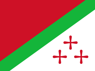
The State of Katanga, also known as the Republic of Katanga, was a breakaway state that proclaimed its independence from Congo-Léopoldville on 11 July 1960 under Moise Tshombe, leader of the local Confédération des associations tribales du Katanga (CONAKAT) political party. The new Katangese state did not enjoy full support throughout the province and was constantly plagued by ethnic strife in its northernmost region. It was dissolved in 1963 following an invasion by United Nations Operation in the Congo (ONUC) forces, and reintegrated with the rest of the country as Katanga Province.
An annual conference is a regional decision-making body within various Methodist denominations. Conferences are a key characteristic of the connectional system of government in Methodism. Annual conferences are composed primarily of the clergy members and a lay member or members from each charge. Each conference is a geographical division. In general, the smaller states in the United States hold one conference each, while larger states often include two or more conferences. Several annual conferences are held in other nations as well.
The Allan Hills are a group of hills, mainly ice free and about 12 nautical miles long, lying just north-west of the Coombs Hills near the heads of Mawson Glacier and Mackay Glacier in the Oates Land and Victoria Land regions of Antarctica.

John McKendree Springer was an American bishop of the Methodist Episcopal Church and The Methodist Church, elected in 1936. He was also a pioneering missionary instrumental in developing Methodism on the continent of Africa. While in Africa he introduced schools which came to be welcomed by many of the tribal chiefs and which the young Africans came to grow very fond of. Springer is noted for exploring and journeying 1500 miles across central Africa on foot in 1907, along with his wife Helen.

Wote is a town in Kenya. It is the capital of Makueni County in the former Eastern Province. It forms a town council with a population of 56,419, of whom 5,542 are classified urban.
Westport is a town in the Canadian province of Newfoundland and Labrador. The town had a population of 185 in 2021, down from 195 in the Canada 2016 Census.
Maximiliano de Almeida is a municipality in the state of Rio Grande do Sul, Brazil. As of 2020, the estimated population was 4,314.
Simpson Glacier is a glacier, 6 nautical miles, in the Admiralty Mountains, Antarctica. It flows northward to the coast between Nelson Cliff and Mount Cherry-Garrard where it forms the Simpson Glacier Tongue.

The Japanese destroyer Hakaze was one of 15 Minekaze-class destroyers built for the Imperial Japanese Navy (IJN) in the late 1910s. During the Pacific War, she supported Japanese operations during the Malayan, Dutch East Indies, and Guadalcanal Campaigns. The ship was sunk by an American submarine in early 1943.
Takelsa is a town and commune in the Nabeul Governorate, Tunisia. As of 2004 it had a population of 20,169.
Zaouiet Sousse is a town and commune in the Sousse Governorate, Tunisia. As of 2014 it had a population of 20,681.
Wold Nunatak is a nunatak standing 10 nautical miles (18 km) east of Mount Manthe in the southeast part of the Hudson Mountains. Mapped by United States Geological Survey (USGS) from surveys and U.S. Navy air photos, 1960–66. Named by Advisory Committee on Antarctic Names (US-ACAN) for Richard J. Wold, United States Antarctic Research Program (USARP) geologist at Byrd Station, 1960–61 season.

Kukri Hills is a prominent east-west trending range, about 25 nautical miles (46 km) long and over 2,000 metres (6,600 ft) high, forming the divide between Ferrar Glacier on the south and Taylor Glacier and Taylor Valley on the north, in Victoria Land, Antarctica.
Fingeren Peak is a peak immediately northwest of Hogskavlpiggen Peak, in the Borg Massif of Queen Maud Land, Antarctica. It was mapped by Norwegian cartographers from surveys and air photos by the Norwegian–British–Swedish Antarctic Expedition (1949–52) and named Fingeren.
Migmatitovaya Rock is a rock at the eastern end of a spur, lying 3 nautical miles (6 km) northeast of Terletskiy Peak in the Shcherbakov Range of the Orvin Mountains, Queen Maud Land, Antarctica. It was roughly plotted from air photos by the Third German Antarctic Expedition, 1938–39, and was mapped from air photos and surveys by the Sixth Norwegian Antarctic Expedition, 1956–60. The feature was remapped by the Soviet Antarctic Expedition, 1960–61, and named "Skala Migmatitovaya".
Salomon Tshizand (1913–1961) was a Congolese and Katangese politician.
References
- ↑ Denyer, Taylor Walters (2020-06-26). Decolonizing Mission Partnerships: Evolving Collaboration between United Methodists in North Katanga and the United States of America. Wipf and Stock Publishers. ISBN 978-1-7252-5911-9.
10°47′S26°38′E / 10.783°S 26.633°E