South Bruce Peninsula is a town at the base of the Bruce Peninsula of Ontario, Canada, in Bruce County between Lake Huron and Georgian Bay. It was formed on January 1, 1999, when the town of Wiarton, the village of Hepworth, and the townships of Albemarle and Amabel were amalgamated. The new municipality was created to provide necessary political representation, administrative support, and necessary municipal services on behalf of the residents.

The Saugeen River is located in southern Ontario, Canada. The river begins in the Osprey Wetland Conservation Lands and flows generally north-west about 160 kilometres (99 mi) before exiting into Lake Huron. The river is navigable for some distance, and was once an important barge route. Today the river is best known for its fishing and as a canoe route.

Bruce County is a county in Southwestern Ontario, Canada. It has eight lower-tier municipalities with a total 2016 population of 66,491. It is named for James Bruce, 8th Earl of Elgin and 12th Earl of Kincardine, the sixth Governor General of the Province of Canada. The Bruce name is also linked to the Bruce Trail and the Bruce Peninsula.

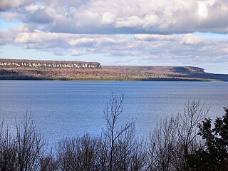
The Bruce Peninsula is a peninsula in Ontario, Canada, that divides Georgian Bay of Lake Huron from the lake's main basin. The peninsula extends roughly northwestwards from the rest of Southwestern Ontario, pointing towards Manitoulin Island, with which it forms the widest strait joining Georgian Bay to the rest of Lake Huron. The Bruce Peninsula contains part of the geological formation known as the Niagara Escarpment. The entire peninsula and nearby communities to the south along Lake Huron are located within Bruce County, Ontario.
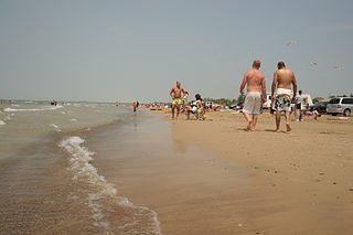
Sauble Beach is a beach community and unincorporated area in the town of South Bruce Peninsula, Bruce County, in the northern area of southwestern Ontario, Canada. It is on the Bruce Peninsula, along the eastern shore of Lake Huron, on the north edge of the Saugeen First Nation. The beach takes its name from that given by early French explorers to the sandy Sauble River, originally "La Rivière Au Sable" also indicating that the river emptied into Lake Huron at a sandy beach. The river was labelled with the French name on maps until 1881, when it became the Sauble River; in early years, a sawmill was built on the river, and later, a hydro electric plant.

The Teeswater River is a river in the municipalities of Arran–Elderslie, Brockton and South Bruce in Bruce County in Southwestern Ontario, Canada. It is in the Great Lakes Basin and empties into the Saugeen River at Paisley, Ontario.

Southampton is a community on the shores of Lake Huron in Bruce County, Ontario, Canada. It is close to Port Elgin and is located at the mouth of the Saugeen River in the Saugeen Ojibway Nation Territory. The size of the town is 6.44 square kilometres. The permanent population in 2016 was 3,678, but the summer population is higher since cottagers and campers spend vacation time in the area.
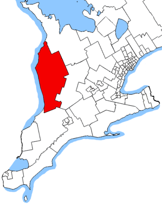
Huron—Bruce is a federal electoral district in Ontario, Canada, that has been represented in the House of Commons of Canada since 1953.
Bruce North was a federal electoral district in Ontario, Canada. It was represented in the House of Commons of Canada from 1867 to 1935 and was created by the British North America Act of 1867, which divided the county of Bruce into two ridings: Bruce North and Bruce South.
Bruce South was a federal electoral district in Ontario, Canada, that was represented in the House of Commons of Canada from 1867 to 1882 and from 1903 to 1935.
Bruce West was a federal electoral district in Ontario, Canada, that was represented in the House of Commons of Canada from 1882 to 1904. This riding was created in 1882 from parts of Bruce North and Bruce South ridings.
Saugeen First Nation is an Ojibway First Nation band located along the Saugeen River and Bruce Peninsula in Ontario, Canada. The band states that their legal name is the "Chippewas of Saugeen". Organized in the mid-1970s, Saugeen First Nation is the primary "political successor apparent" to the Chippewas of Saugeen Ojibway Territory; the other First Nation that is a part of Chippewas of Saugeen Ojibway Territory is Cape Croker. The Ojibway are of the Algonquian languages family. The First Nation consist of four reserves: Chief's Point 28, Saugeen 29, Saugeen Hunting Grounds 60A, and Saugeen and Cape Croker Fishing Islands 1.
Saugeen Shores is a town in Bruce County, Ontario, Canada, formed in 1998. In addition to the two main population centres of Southampton and Port Elgin, the town includes a portion of the village of Burgoyne and the North Bruce area, straddling the municipal eastern and southern boundary respectively. In 2016, the permanent population of Saugeen Shores was 13,715, in a land area of 171.05 square kilometres (66.04 sq mi).

Port Elgin is a community in the town of Saugeen Shores, Ontario, Canada. Its location is in the traditional territory of the Saugeen Ojibway Nation. Originally named Normanton the town was renamed Port Elgin when it was incorporated in 1874, after James Bruce, 8th Earl of Elgin, a former Governor General of the Province of Canada.
The Western Ontario Athletic Association (WOAA) is the governing body of minor and senior sports in a region encompassing Grey County, Bruce County, Perth County, Huron County, northern Middlesex County, and northern Wellington County. The WOAA Senior Hockey League has been around since 1948.
Bluewater District School Board is a school board in the Canadian province of Ontario, with jurisdiction for the operation of schools in Bruce and Grey Counties.

Huron-Kinloss is a township in the Canadian province of Ontario, located within Bruce County. The township had a population of 7,069 in the Canada 2016 Census.
The Saugeen Valley Conservation Authority (SVCA) is a conservation authority in Ontario, Canada. It operates under the Conservation Authorities Act of Ontario. It is a corporate body, through which municipalities, landowners and other organizations work cooperatively to manage the Saugeen River watershed and natural resources within it.
The Wellington, Grey and Bruce Railway (WG&BR) was a railway in Ontario, Canada. It ran roughly northwest from Guelph to the port town of Southampton on Lake Huron, a distance of 101 miles (163 km). It also had a 66-mile (106 km) branch line splitting off at Palmerston and running roughly westward to Kincardine, another port town. A branch running south from Southampton was built during the construction of the Bruce Nuclear Generating Station in the 1970s.
Elections were held in Bruce County, Ontario on October 24, 2022, in conjunction with municipal elections across the province.