
The American Hockey League (AHL) is a professional ice hockey league based in the United States and Canada that serves as the primary developmental league for the National Hockey League (NHL). As of the 2024–25 AHL season, all 32 NHL teams held affiliations with an AHL team. Historically, when an NHL team does not have an AHL affiliate, its players are assigned to AHL teams affiliated with other NHL franchises.

Events from the year 1973 in Canada.

Seaforth is a Southern Ontario community in the municipality of Huron East, in Huron County, Ontario, Canada.

Elmira is the largest community in the township of Woolwich, Ontario, Canada. It is 15 kilometres (9 mi) north of the city of Waterloo near the Regional Municipality of Waterloo's northern border with Wellington County. The community was listed in the 2016 Canadian census as having a population of 10,161.

Kincardine is a municipality located on the shores of Lake Huron in Bruce County in the province of Ontario, Canada. The current municipality was created in 1999 by the amalgamation of the Town of Kincardine, the Township of Kincardine, and the Township of Bruce.

Maple Leaf Gardens is a historic building located at the northwest corner of Carlton Street and Church Street in Toronto, Ontario, Canada. The building was originally constructed in 1931 as an indoor arena to host ice hockey games.

Charles Joseph Sylvanus Apps, was a Canadian professional ice hockey player for the Toronto Maple Leafs from 1936 to 1948, an Olympic pole vaulter and a Conservative Member of Provincial Parliament in Ontario. In 2017 Apps was named one of the '100 Greatest NHL Players' in history.

Howard William Meeker was a Canadian professional hockey player in the National Hockey League, youth coach and educator in ice hockey, and a Progressive Conservative Member of Parliament. He became best known to Canadians as an excitable and enthusiastic television colour commentator for Hockey Night in Canada, breaking down strategy in between periods of games with early use of the telestrator. In the 1970s, he ran hockey camps and created numerous books and a television series promoting youth education in the sport.
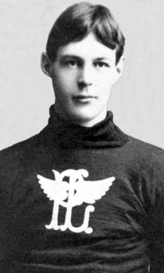
William Hodgson "Hod" Stuart was a Canadian professional ice hockey cover-point who played nine seasons for several teams in different leagues from 1899 to 1907. He also played briefly for the Ottawa Rough Riders football team. With his brother Bruce, Stuart played in the first professional ice hockey league, the American-based International Professional Hockey League (IPHL), where he was regarded as one of the best players in the league.
The 1958–59 NHL season was the 42nd season of the National Hockey League. Six teams each played 70 games. The Montreal Canadiens were the Stanley Cup champions as they beat the Toronto Maple Leafs four games to one in the best-of-seven final series. This marked the fourth consecutive Stanley Cup win for the Canadiens as they became the first team to win four in a row.
The St. Catharines Saints was a minor league ice hockey team in St. Catharines, Ontario. It played in the American Hockey League from 1982 to 1986 as the farm team of the Toronto Maple Leafs.

The New Brunswick Hawks were a professional ice hockey team based in Moncton, New Brunswick. Home games were played at the Moncton Coliseum. They were a member of the American Hockey League (AHL) between 1978 and 1982. The Hawks operated as a minor league affiliate of the Chicago Black Hawks and the Toronto Maple Leafs, with a winning record each of four seasons.

The Township of Ashfield–Colborne–Wawanosh is a municipality in Huron County, Ontario, Canada. It was formed as an amalgamation of the former Ashfield, Colborne and West Wawanosh townships in 2001, in an Ontario-wide local government restructuring imposed by the government of that time. The three former townships now comprise the wards of the amalgamated municipality.

Point Clark is a lakefront cottage community on Lake Huron, in the municipality of Huron-Kinloss, Ontario, Canada. It is approximately 15 kilometres south of Kincardine and 40 kilometres north of Goderich. Main streets include Huron Road and Lake Range Road. Point Clark is served by Highway 21 (Ontario). It is a cottage town, and has a rare Imperial Tower style lighthouse. There is a sandy beach and a small harbour with a boat ramp. There are two streams or rivers that run into Lake Huron around Point Clark: Clark Creek and Pine River. There is a separate harbour in the mouth of the Pine River. Amberley is just outside and to the south of Point Clark and Lucknow is to the south-east of Point Clark.
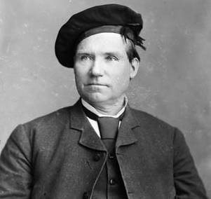
James Somerville was an Ontario businessman, notary public and political figure. He represented Bruce West in the House of Commons of Canada as a Liberal member from 1882 to 1887.

Allan Wilfrid Pickard was a Canadian ice hockey administrator, who served as president of the Canadian Amateur Hockey Association (CAHA) from 1947 to 1950. When Canada opted out of the 1947 Ice Hockey World Championships and decided not to participate in the 1948 Winter Olympics, Pickard felt that Canada was obliged to send a team due to its place as a top hockey nation, and nominated the Ottawa RCAF Flyers who won the gold medal for Canada and lived up to the requirements of the Olympic Oath as amateurs. Despite disagreement with the International Olympic Committee, he sought for the International Ice Hockey Federation to adopt the CAHA definition of amateur in the face of increasing difficulty in selecting the Canada men's national ice hockey team.
Lawrence Joseph Jeffrey was a Canadian professional ice hockey player, who played forward. He played for the Detroit Red Wings, Toronto Maple Leafs, and New York Rangers of the National Hockey League from 1961 to 1969. Jeffrey was a member of the 1967 Stanley Cup-winning Maple Leafs.
David Allan Farrish is a Canadian former professional ice hockey defenceman who played 430 games in the National Hockey League (NHL) with the New York Rangers, Quebec Nordiques, and Toronto Maple Leafs between 1976 and 1984. He featured in the 1979 Stanley Cup Finals with the Rangers.

Huron-Kinloss is a township in the Canadian province of Ontario, located within Bruce County. The township had a population of 7,069 in the Canada 2016 Census.

Kincardine is a community and former town, located in the municipality of Kincardine on the shores of Lake Huron in Bruce County in the province of Ontario, Canada. The namesake town is located at the mouth of the Penetangore River, and was founded in 1848 by the name of Penetangore. The current municipality was created in 1999 by the amalgamation of the Town of Kincardine, the Township of Kincardine, and the Township of Bruce. The former town is Ward 1 within the current municipal boundaries.

