
Scugog is a township in the Regional Municipality of Durham, south-central Ontario, Canada. It is northeast of Toronto and just north of Oshawa. Due to its location in the Greater Toronto Area, many residents commute to Toronto for work on a daily basis. The anchor and largest population base of the township is Port Perry. The township has a population of roughly 22,500. A smaller Scugog Township was also a historic municipality and geographic township prior to the amalgamation that formed the current municipality.

Brock is a township in the Regional Municipality of Durham, Ontario, Canada. Brock Township is also a former municipality and geographic township prior to the amalgamation that formed the current municipality.

Actinolite is an unincorporated compact rural community in geographic Elzevir Township in the Municipality of Tweed, Hastings County in Central Ontario, Canada. It is on Ontario Highway 37, just south of Ontario Highway 7 and north of the village of Tweed. The community also lies on the Skootamatta River just north of that river's mouth at the Moira River. Greyhound Canada express buses between Toronto and Ottawa use Actinolite's Log Cabin Restaurant as a rest stop.

Actons Corners is a community in the municipality of North Grenville, United Counties of Leeds and Grenville, in eastern Ontario, Canada. An unincorporated place and compact rural community, it is located on County Road 43 between Kemptville and Merrickville at the intersection with Actons Corners Road and County Road 25.

Kincardine is a municipality located on the shores of Lake Huron in Bruce County in the province of Ontario, Canada. The current municipality was created in 1999 by the amalgamation of the Town of Kincardine, the Township of Kincardine, and the Township of Bruce.
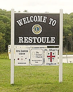
Restoule is a community and designated place in geographic Patterson Township in the Centre Unorganized Part of Parry Sound District in Central Ontario, Canada. It is situated on the Restoule River between Commanda Lake, and Restoule Lake and is part of the Almaguin Highlands region.

The Crowe River is a river in the counties of Haliburton, Hastings, Northumberland and Peterborough in southern Ontario, Canada. It is in the Lake Ontario drainage basin and is a tributary of the Trent River.
Tara is an unincorporated community in the municipality of Arran–Elderslie, Bruce County, in southwestern Ontario, Canada. It is a designated place and had 1,037 residents and 458 dwellings as of the 2011 census. Tara is in geographic Arran Township and is located on the Sauble River. It has an area of 2.39 square kilometres (0.92 sq mi) and an urban area that covers 63.5 square kilometres (24.5 sq mi).
Foleyet is an unincorporated community in the Unorganized North Part of Sudbury District in Northeastern Ontario, Canada, midway between Chapleau and Timmins on Highway 101. The town was created during the construction of the Canadian Northern Railway (CNR) through the area in the early years of the 20th century.
King's Highway 9, commonly referred to as Highway 9, is a provincially maintained highway in the Canadian province of Ontario. Highway 9 has been divided into two segments since January 1, 1998, when the segment between Harriston and Orangeville was downloaded to the various counties in which it resided. The western segment of the highway begins at Highway 21 in Kincardine, near the shores of Lake Huron. It travels 73 km (45 mi) to the junction of Highway 23 and Highway 89 in Harriston. The central segment is now known as Wellington County Road 109 and Dufferin County Road 109. At Highway 10 in Orangeville, Highway 9 resumes and travels east to Highway 400. The highway once continued east to Yonge Street in Newmarket, but is now known as York Regional Road 31.
Little Britain is a compact rural community in the City of Kawartha Lakes, Ontario, Canada. It is located 15 kilometres (9.3 mi) southwest of Lindsay. Formerly a part of Mariposa Township and Victoria County, Little Britain is now part of Ward 8, City of Kawartha Lakes.

South Algonquin is a township municipality in Nipissing District, Ontario, Canada. Located south of Algonquin Provincial Park, it is the sole populated portion of the district that lies south of the traditional dividing line between Northern Ontario and Southern Ontario and is closer connected to Renfrew County as opposed to the core portions of Nipissing District.

Jogues is a dispersed rural community and unincorporated place in geographic Way Township, Cochrane District in Northeastern Ontario, Canada. It is about 11 kilometres (6.8 mi) southwest of Hearst. Jogues is also a designated place served by a local services board.

Queensborough is an unincorporated community in the municipality of Tweed, Hastings County, in Central Ontario, Canada. It is located north of Ontario Highway 7 on the Black River, about 20 kilometres (12 mi) north-west of the village of Tweed and 15 kilometres (9.3 mi) north-east of the town of Madoc.

Maple Hill is an dispersed rural community in the township municipality of Brockton, Bruce County, Ontario, Canada.
Salem is a Dispersed Rural Community and unincorporated place in the municipality of South Bruce, Bruce County in southwestern Ontario, Canada. The community is in geographic Culross Township at the intersection of Bruce County Road 4 and Concession Road 12, 6 kilometres (3.7 mi) north of the community of Teeswater and 7 kilometres (4.3 mi) west of the community of Formosa, and is the location of a United Church built in 1872.
Underwood is a village in the Municipality of Kincardine, Bruce County, Ontario, Canada, located just south of North Bruce on Highway 21.

Kincardine is a community and former town, located in the municipality of Kincardine on the shores of Lake Huron in Bruce County in the province of Ontario, Canada. The namesake town is located at the mouth of the Penetangore River, and was founded in 1848 by the name of Penetangore. The current municipality was created in 1999 by the amalgamation of the Town of Kincardine, the Township of Kincardine, and the Township of Bruce. The former town is Ward 1 within the current municipal boundaries.
Salem is a dispersed rural community and unincorporated place in the municipality of Arran–Elderslie, Bruce County in southwestern Ontario, Canada. The community is in geographic Elderslie Township at the intersection of Concession 10 Elderslie and Sideroad 15 South Elderslie, 10 kilometres (6.2 mi) northwest of the community of Chesley and 9 kilometres (5.6 mi) northeast of the community of Paisley. The community is on Snake Creek, a tributary of the Saugeen River.
