Leith is an unincorporated community in Ontario, Canada, named after Leith, Scotland. It is located on the eastern shore of the Owen Sound Bay, an inlet (sound) on the south shore of Georgian Bay on Lake Huron. Owen Sound Bay is a broad valley that cuts through the Niagara Escarpment. The valley preceded the last great Ice Age, but was broadened by the action of the glacial ice, then by the erosive forces of the Sydenham and Pottowatomi rivers. During his preliminary survey of Lake Huron in 1815, Captain William Fitzwilliam Owen named it "Owen's Sound" for his brother, Admiral Sir Edward William Campbell Rich Owen.

The Rouge River is a river in Markham, Pickering, Richmond Hill and Toronto in the Greater Toronto Area of Ontario, Canada. The river flows from the Oak Ridges Moraine to Lake Ontario at the eastern border of Toronto, and is the location of Rouge Park, the only national park in Canada within a municipality. At its southern end, the Rouge River is the boundary between Toronto and southwestern Pickering in the Regional Municipality of Durham.

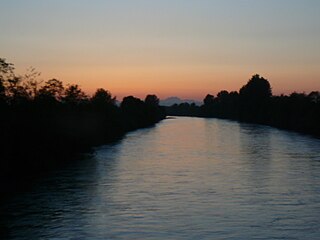
The Saugeen River is located in southern Ontario, Canada. The river begins in the Osprey Wetland Conservation Lands and flows generally north-west about 160 kilometres (99 mi) before exiting into Lake Huron. The river is navigable for some distance, and was once an important barge route. Today the river is best known for its fishing and as a canoe route.

Bruce County is a county in Southwestern Ontario, Canada comprising eight lower-tier municipalities and with a 2016 population of 66,491. It is named for James Bruce, 8th Earl of Elgin and 12th Earl of Kincardine, sixth Governor General of the Province of Canada. The Bruce name is also linked to the Bruce Trail and the Bruce Peninsula. It has three distinct areas. The Peninsula is part of the Niagara Escarpment and is known for its views, rock formations, cliffs, and hiking trails. The Lakeshore includes nearly 100 km of fresh water and soft sandy beaches. Finally, the Interior Region has a strong history in farming.
The Puyallup River is a river in the U.S. state of Washington. About 45 miles (72 km) long, it is formed by glaciers on the west side of Mount Rainier. It flows generally northwest, emptying into Commencement Bay, part of Puget Sound. The river and its tributaries drain an area of about 948 square miles (2,460 km2) in Pierce County and southern King County.

The Sauble River is a river in Bruce County and Grey County in southwestern Ontario, Canada that flows from its headwaters in the township of Chatsworth to Lake Huron at the community of Sauble Beach.
The Rankin River is a river in the town of South Bruce Peninsula, Bruce County in southwestern Ontario, Canada which flows from the east side of the Bruce Peninsula to join the Sauble River near Sauble Falls Provincial Park on the west side. The river is in the Lake Huron drainage basin and was named after Charles Rankin, who first surveyed the Bruce Peninsula.

The Maitland River is a river in Huron County, Perth County and Wellington County in Southwestern Ontario, Canada. The river is in the Great Lakes Basin and empties into Lake Huron at the town of Goderich. It is 150 kilometres (93 mi) long, and is named after Sir Peregrine Maitland, Lieutenant-Governor of Upper Canada from 1818 to 1828. It was formerly known as the Menesetung River.

Southampton is a community on the shores of Lake Huron in Bruce County, Ontario, Canada, and close to Port Elgin. It is located at the mouth of the Saugeen River in the Saugeen Ojibway Nation Territory. The size of the town is 6.44 square kilometres. The permanent population in 2016 was 3,678 but the summer population is higher, due to cottagers and campers spending vacation time in the area.

The Coquitlam River is a tributary of the Fraser River in the Canadian province of British Columbia. The river's name comes from the word Kʷikʷəƛ̓əm which translates to "Red fish up the river". The name is a reference to a sockeye salmon species that once occupied the river's waters.
A conservation authority is a local, community-based natural resource management agency based in Ontario, Canada. Conservation authorities represent groupings of municipalities on a watershed basis and work in partnership with other agencies to carry out natural resource management activities within their respective watersheds, on behalf of their member municipalities and the Province of Ontario.

The Lake Simcoe Region Conservation Authority is a conservation authority established in 1951, and is among the oldest in the Canadian province of Ontario.
Trail Creek is a 7.3-mile-long (11.7 km) north- by northwest-flowing stream whose main stem begins at the confluence of the West Branch Trail Creek and the East Branch Trail Creek in LaPorte County, Indiana, United States. Its mouth is a Lake Michigan harbor and marina adjacent to Michigan City, Indiana's lakefront Washington Park.
The Saugeen Valley Conservation Authority (SVCA) is a conservation authority in Ontario, Canada. It operates under the Conservation Authorities Act of Ontario. It is a corporate body, through which municipalities, landowners and other organizations work cooperatively to manage the Saugeen River watershed and natural resources within it.

Kincardine is a community and former town, located in the municipality of Kincardine on the shores of Lake Huron in Bruce County in the province of Ontario, Canada. The namesake town is located at the mouth of the Penetangore River, and was founded in 1848 by the name of Penetangore. The current municipality was created in 1999 by the amalgamation of the Town of Kincardine, the Township of Kincardine, and the Township of Bruce. The former town is Ward 1 within the current municipal boundaries.

Gravel Run is a tributary of the Susquehanna River in Northumberland County, Pennsylvania, in the United States. It is approximately 4.4 miles (7.1 km) long and flows through Rush Township and Upper Augusta Township. The watershed of the stream has an area of 6.33 square miles (16.4 km2). A number of bridges cross the stream and a mill was also historically present along it. The stream is considered to be a Coldwater Fishery and a Migratory Fishery. It has a number of unnamed tributaries.
The West Branch Lackawanna River is a tributary of the Lackawanna River in Susquehanna County, Pennsylvania, in the United States. It is approximately 9.5 miles (15.3 km) long and flows through Ararat Township, Herrick Township, and Union Dale. The watershed of the river has an area of 16.8 square miles (44 km2). The river is not designated as an impaired stream and it has a high level of water quality. Lakes and wetlands in the river's watershed include Ball Lake, Fiddle Lake, Hathaway Lake, Lake Romobe, Lewis Lake, Lowe Lake, and Sink Hole Swamp. The river is also dammed by at least two dams: the Romobe Lake Dam and the Hathaway Pond Dam.
East Kill, a 16-mile-long (26 km) tributary of Schoharie Creek, flows across the town of Jewett, New York, United States, from its source on Stoppel Point. Ultimately its waters reach the Hudson River via the Mohawk. Since it drains into the Schoharie upstream of Schoharie Reservoir, it is part of the New York City water supply system. East Kill drains the southern slopes of the Blackhead Mountains, which include Thomas Cole Mountain, Black Dome, and Blackhead Mountain, the fourth-, third-, and fifth-highest peaks in the Catskills, respectively.

Batavia Kill is a 21-mile-long (34 km) tributary of Schoharie Creek, that flows across the towns of Windham, Ashland and Prattsville in the U.S. state of New York. Its waters reach the Hudson River via Schoharie Creek and the Mohawk River. Since it drains into the Schoharie upstream of Schoharie Reservoir, it is part of the New York City water supply system. From the source to Maplecrest, Batavia Kill drains the northern slopes of the Blackhead Mountains, which include Thomas Cole Mountain, Black Dome, and Blackhead Mountain, the fourth-, third-, and fifth-highest peaks in the Catskills, respectively.
Mingan River is a 117-kilometre (73 mi) salmon river of the Côte-Nord region of Quebec. It flows from north to south and empties into the Gulf of Saint Lawrence.

