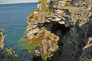
Bruce Peninsula National Park is a national park on the Bruce Peninsula in Ontario, Canada. Located on a part of the Niagara Escarpment, the park comprises 156 square kilometres and is one of the largest protected areas in southern Ontario, forming the core of UNESCO's Niagara Escarpment World Biosphere Reserve. It was established in 1987 to protect the rock formations and shoreline of the Niagara Escarpment. The park offers opportunities for many outdoor activities, including hiking, camping, and bird watching. The park has trails ranging in difficulty from easy to expert, and connects to the Bruce Trail. Bruce Peninsula National Park is known for its crystal clear blue waters, cobblestone beaches, rocky cliffs and karst formations.

The Bruce Trail is a hiking trail in southern Ontario, Canada, from the Niagara River to the tip of Tobermory, Ontario. The main trail is more than 890 km (550 mi) long and there are over 400 km (250 mi) of associated side trails. The trail mostly follows the edge of the Niagara Escarpment, one of the nineteen UNESCO World Biosphere Reserves in Canada. The land the trail traverses is owned by the Government of Ontario, local municipalities, local conservation authorities, private landowners, and the Bruce Trail Conservancy (BTC). The Bruce Trail is the oldest and longest marked hiking trail in Canada. Its name is linked to the Bruce Peninsula and Bruce County, through which the trail runs. The trail is named after the county, which was named after James Bruce, 8th Earl of Elgin who was Governor General of the Province of Canada from 1847 to 1854.

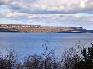
The Niagara Escarpment is a long escarpment, or cuesta, in Canada and the United States that runs predominantly east–west from New York through Ontario, Michigan, Wisconsin, and into Illinois. The escarpment is most famous as the cliff over which the Niagara River plunges at Niagara Falls, for which it is named.
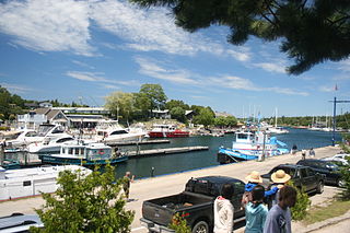
Tobermory is a small community located at the northern tip of the Bruce Peninsula, in the traditional territory of the Saugeen Ojibway Nation. Until European colonization in the mid-19th century, the Bruce Peninsula was home to the Saugeen Ojibway nations, with their earliest ancestors reaching the area as early as 7500 years ago. It is part of the municipality of Northern Bruce Peninsula. It is 300 kilometres northwest of Toronto. The closest city to Tobermory is Owen Sound, 100 kilometres south of Tobermory and connected by Highway 6.
South Bruce Peninsula is a town at the base of the Bruce Peninsula of Ontario, Canada, in Bruce County between Lake Huron and Georgian Bay. It was formed on January 1, 1999, when the town of Wiarton, the village of Hepworth, and the townships of Albemarle and Amabel were amalgamated. This new municipality was created to provide necessary political representation, administrative support and necessary municipal services on behalf of the residents.

Bruce County is a county in Southwestern Ontario, Canada comprising eight lower-tier municipalities and with a 2016 population of 66,491. It is named for James Bruce, 8th Earl of Elgin and 12th Earl of Kincardine, sixth Governor General of the Province of Canada. The Bruce name is also linked to the Bruce Trail and the Bruce Peninsula. It has three distinct areas. The Peninsula is part of the Niagara Escarpment and is known for its views, rock formations, cliffs, and hiking trails. The Lakeshore includes nearly 100 km of fresh water and soft sandy beaches. Finally, the Interior Region has a strong history in farming.

The Bruce Peninsula is a peninsula in Ontario, Canada, that divides Georgian Bay of Lake Huron from the lake's main basin. The peninsula extends roughly northwestwards from the rest of Southwestern Ontario, pointing towards Manitoulin Island, with which it forms the widest strait joining Georgian Bay to the rest of Lake Huron. The Bruce Peninsula contains part of the geological formation known as the Niagara Escarpment.

Fathom Five National Marine Park is a National Marine Conservation Area in the Georgian Bay part of Lake Huron, Ontario, Canada, that seeks to protect and display shipwrecks and lighthouses, and conserve freshwater ecosystems. Parks Canada has management plans for the aquatic and terrestrial ecosystems, with a multi-action plan for species that are at risk, including endemic species, the Monarch butterfly, the eastern ribbonsnake, and the eastern whip-poor-will. The aquatic ecosystems in the park are also of particular interest. Many fish, shellfish, amphibians, and eels are an attraction for naturalists in the park. Much of this wildlife is accessible to scuba divers and snorkellers in the park. The many shipwrecks make the park a popular scuba diving destination, and glass bottom boat tours leave Tobermory regularly, allowing tourists to see the shipwrecks without having to get wet. Additionally, there are three main popular hiking trails found within Fathom Five National Marine Park that provides visitors with views of old growth forests and the Georgian Bay. The Saugeen Ojibway Peoples have inhabited the Bruce Peninsula and the area that is now Fathom Five National Marine Park for thousands of years. This land provided for their communities and their people with the plethora of wildlife and plant life. They provide the local knowledge about Lake Huron and its ecological value to the reserve, park, and their overall livelihood. Parks Canada and Saugeen Ojibway People's collaboration is said to yield a benefit to both parties with regard to overall ecosystem knowledge.

Wiarton is a community in the town of South Bruce Peninsula, Bruce County, Ontario, Canada. It is located at the western end of Colpoys Bay, an inlet off Georgian Bay, on the Bruce Peninsula.
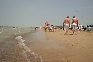
Sauble Beach is a beach community and unincorporated area in the town of South Bruce Peninsula, Bruce County, in the northern area of southwestern Ontario, Canada. It is on the Bruce Peninsula, along the eastern shore of Lake Huron, on the north edge of the Saugeen First Nation. The beach takes its name from that given by early French explorers to the sandy Sauble River, originally "La Rivière Au Sable" also indicating that the river emptied into Lake Huron at a sandy beach. The river was labelled with the French name on maps until 1881, when it became the Sauble River; in early years, a sawmill was built on the river, and later, a hydro electric plant.
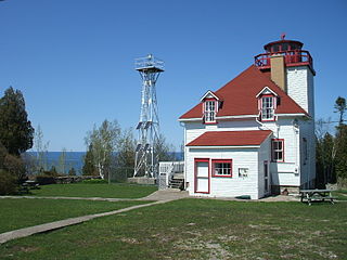
Cabot Head is a point of land on the northeast tip of the Bruce Peninsula in the Canadian province of Ontario. The Bruce Peninsula separates Georgian Bay from the rest of Lake Huron. Cabot Head is so named in honor of the explorer John Cabot, although Cabot never explored the Great Lakes. The name of the area was bestowed by John Graves Simcoe (1752-1806).

The Wiikwemkoong First Nation is a First Nation on Manitoulin Island in Northern Ontario. The Wiikwemkoong Unceded Territory is the First Nation reserve in the northeast of Manitoulin Island in Manitoulin District, Ontario, Canada. Wiikwemkoong is an unceded Indigenous reserve in Canada, which means that it has not "relinquished title to its land to the government by treaty or otherwise."

Lion's Head is a community in the municipality of Northern Bruce Peninsula, Bruce County, Ontario, Canada. It is located at the midway point of the Bruce Peninsula, about halfway between Owen Sound and Tobermory, just east of Ferndale on Bruce Road 9. Lion's Head is located on the 45th parallel north, halfway between the Equator and the North Pole. The town is named after the resemblance of a lion's profile in the rock formation of the Niagara Escarpment. The first post office opened in 1895.

Hesquiat Peninsula Provincial Park is a provincial park at the western extremity of the Clayoquot Sound region of the West Coast of Vancouver Island, British Columbia, Canada. The park was established by order-in-council on July 12, 1995 as part of the Clayoquot Land-Use Decision.

The Municipality of Northern Bruce Peninsula is located on the Bruce Peninsula in Bruce County, Ontario, Canada. It is a popular vacation spot in the summer for its water sports and cottaging, and in the winter for snowmobiling. The municipality was formed on January 1, 1999, when the townships of St. Edmunds, Lindsay, and Eastnor, as well as the Village of Lion's Head, were amalgamated.
The Robinson Treaties are two treaties signed between the Ojibwa chiefs and The Crown in 1850 in the Province of Canada. The first treaty involved Ojibwa chiefs along the north shore of Lake Superior, and is known as the Robinson Superior Treaty. The second treaty, signed two days later, included Ojibwa chiefs from along the eastern and northern shores of Lake Huron, and is known as the Robinson Huron Treaty. The Wiikwemkoong First Nation did not sign either treaty, and their land is considered "unceded".
Chippewas of Nawash Unceded First Nation is an Anishinaabek First Nation from the Bruce Peninsula region in Ontario, Canada. Along with the Saugeen First Nation, they form the Saugeen Ojibway Nation. The Chippewas of Nawash Unceded First Nation currently has a registered membership of 2758 individuals, as of December, 2020. Approximately 700 members live on the main reserve, Neyaashiinigmiing 27. The First Nation has 3 reserves, Neyaashiinigmiing 27, Cape Croker Hunting Ground 60B and Saugeen and Cape Croker Fishing Islands 1. The size of all reserves is 8083.70 hectares.

Bruce Peninsula is a Canadian indie rock band, whose style has been described as "a near indescribable and rousing potpourri of prog, gospel, folk, rock, pop and country." The band consists of core members Matt Cully on vocals and guitar, Misha Bower on vocals, Neil Haverty on vocals, guitar and metallophone, Andrew Barker on bass guitar and lap steel and Steve McKay on drums.

Motu Manawa-Pollen Island Marine Reserve is a 501 hectares (1.93 sq mi) protected area in the Waitemata Harbour in Auckland, New Zealand, established in 1996. It includes the entire area between Rosebank Peninsula and Waterview, and surrounds Motumānawa / Pollen Island and Traherne Island. Its northeastern boundary runs roughly parallel to Rosebank Peninsula, from the mouth of the Oakley Creek estuary. Its northernmost boundary is north of Pollen Island, at the same latitude as the tip of Point Chevalier. Its westernmost point is in the mouth of the Whau River, between the tip of Rosebank Peninsula and Te Atatū. It is bisected by the Northwestern Motorway.

The Niagara Escarpment Biosphere Reserve is a UNESCO Biosphere Reserve located in Ontario, Canada. The reserve stretches 725 kilometres (450 mi) along the Niagara Escarpment from Lake Ontario to the tip of the Bruce Peninsula. The Escarpment corridor crosses two major biomes: needle leaf forests in the north and temperate broadleaf forest in the south.
