
Georgian Bay is a large bay of Lake Huron, in the Laurentia bioregion. It is located entirely within the borders of Ontario, Canada. The main body of the bay lies east of the Bruce Peninsula and Manitoulin Island. To its northwest is the North Channel.

The Bruce Peninsula is a peninsula in Ontario, Canada, that divides Georgian Bay of Lake Huron from the lake's main basin. The peninsula extends roughly northwestwards from the rest of Southwestern Ontario, pointing towards Manitoulin Island, with which it forms the widest strait joining Georgian Bay to the rest of Lake Huron. The Bruce Peninsula contains part of the geological formation known as the Niagara Escarpment.

Southampton is a community on the shores of Lake Huron in Bruce County, Ontario, Canada, and close to Port Elgin. It is located at the mouth of the Saugeen River in the Saugeen Ojibway Nation Territory. The size of the town is 6.44 square kilometres. The permanent population in 2016 was 3,678 but the summer population is higher, due to cottagers and campers spending vacation time in the area.

Grand Traverse Light is a lighthouse in the U.S. state of Michigan, located at the tip of the Leelanau Peninsula, which separates Lake Michigan and Grand Traverse Bay. It marks the Manitou passage, where Lake Michigan elides into Grand Traverse Bay. In 1858, the present light was built, replacing a separate round tower built in 1852. The lighthouse is located inside Leelanau State Park, 8 miles (13 km) north of Northport, a town of about 650 people. This area, in the Michigan wine country, is commonly visited by tourists during the summer months.
The Imperial Towers of Ontario were six of the earliest lighthouses built on Lake Huron and Georgian Bay, all constructed primarily of stone, by the Province of Canada. The origin of the designation Imperial is not certain, but some historians speculate that because the towers were public construction built under the colonial administration while Canada was a self-governing colony of Britain, the name would assure at least some funding from the British Empire's Board of Trade.

John Brown (1809–1876) was a Canadian builder of Scottish origin.

Forty Mile Point Light is a lighthouse in Presque Isle County near Hammond Bay on the western shore of Lake Huron in Rogers Township, Michigan USA.

Chantry Island is a small island in Lake Huron, south of the mouth of the Saugeen River and approximately a kilometre off the shores of the town of Southampton, Ontario. It is approximately 19 hectares in size and is a migratory bird sanctuary. Since the sanctuary territory extends 183 metres into the water surrounding the island, the total official area is listed as 63 hectares.

The Sturgeon Point Light Station is a lighthouse on Lake Huron in Haynes Township, Alcona County, northeastern lower Michigan. Established to ward mariners off a reef that extends 1.5 miles (2.4 km) lakeward from Sturgeon Point, it is today regarded as a historic example of a Cape Cod style Great Lakes lighthouse.

Huron-Kinloss is a township in the Canadian province of Ontario, located within Bruce County. The township had a population of 7,069 in the Canada 2016 Census.
Pointe aux Barques Lighthouse is an active lighthouse located in Huron County in the U.S. state of Michigan. It is located along the shores of Lake Huron on the northeastern tip of the Thumb. Originally constructed in 1848, it is one of the oldest active lighthouses in the state. The name is translated as "point of little boats" from the French language, which refers to the shallow coastline that poses a threat to larger boats.
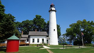
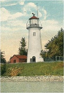
Point Clark Lighthouse is located on in a beach community, Point Clark, Ontario, near a point that protrudes into Lake Huron. Built between 1855 and 1859 under the instructions of the Board of Works, Canada West, it is one of the few on the Great Lakes to be made primarily from stone. It is one of the Imperial Towers, a group of six nearly identical towers built by contractor John Brown for the "Province of Canada" on Lake Huron and Georgian Bay, all completed by 1859. The location for the Point Clark lighthouse was selected to warn sailors of the shoals (sandbars) 2 miles (3.2 km) off the Lake Huron coast. It is still functioning as an automated light. A restoration that eventually exceeded $2.3 million started in 2011 and the facility reopened for tourism in June 2015.

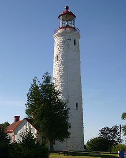
The Cove Island Light, at Gig Point on the island, is located in Fathom Five National Marine Park, but is not part of the Park. It is situated on the Bruce Peninsula, Ontario Canada. It has been a navigational aid in the narrow channel between Lake Huron and Georgian Bay since 30 October 1858. It was the first of six stone Imperial Towers to be completed; all were illuminated by 1859. Most other lighthouses of the era were built of brick, wood, iron or concrete.
The history of lighthouses in Canada dates back to 1734.

The Kincardine Lighthouse is a historic lighthouse located in Kincardine, Ontario, near the mouth of the Penetangore River. Built in 1881, it is 24.4 metres tall and was built above the light keeper's home. The tower is eight sided and sits on a stone foundation. The facility has been renovated and is now the Kincardine Yacht Club and a museum. It is open for tours from July 1 to Labour Day.

The North Point Lighthouse Museum is a lighthouse built in 1888 in Lake Park on the East Side of Milwaukee in Milwaukee County, Wisconsin, United States to mark the entrance to the Milwaukee River. The lighthouse was added to the National Register of Historic Places in 1984. It was also added to the Library of Congress Historic American Buildings Survey as survey HABS WI-358.
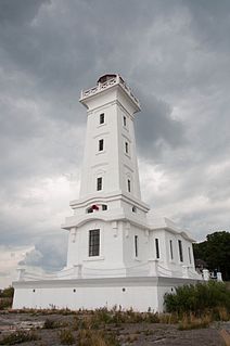
The Chantry Island Lighthouse, officially known as Chantry Island Lightstation Tower, is a lightstation on Chantry Island, off the coast of Southampton, Ontario in Lake Huron. It was constructed in the years 1855 through to 1859, by John Brown of Thorold, Ontario, under the authority of the Province of Canada and is recognized as one of the six Imperial Towers. Virtually identical, they were completed in 1858-1859 on Lake Huron and Georgian Bay and are among the few lighthouses on the Great Lakes made of cut limestone and granite.
The Point Abino Light Tower is a lighthouse on the rocky north shore of Lake Erie at the southern tip of Point Abino peninsula west of Crystal Beach, Ontario, Canada. The Greek Revival white square tower with red accents is attached to the fog alarm building, and a lighthouse keeper's residence is located on the shore to the north.
The Bois Blanc Island Lighthouse and Blockhouse is a National Historic Site of Canada located in Ontario on Bois Blanc Island, one of the islands in the Detroit River. It consists of a lighthouse, owned by Parks Canada, and a blockhouse, which is privately owned.
