
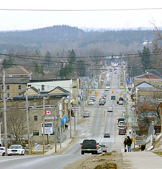
Walkerton is a Town in the Canadian province of Ontario, located within and governed by the municipality of Brockton. It is the site of Brockton's municipal offices and the county seat of Bruce County. It is located on the Saugeen River, at the junction of King's Highway 9 and formerly King's Highway 4 and is 75 km southwest of Owen Sound. As of 2011, the town had 4,967 people in the community.
West Grey is a township in the northern area of Southwestern Ontario, Canada, in Grey County spanning across the River Styx, the Rocky Saugeen River, the Beatty Saugeen River, and the South Saugeen River.

The Saugeen River is located in southern Ontario, Canada. The river begins in the Osprey Wetland Conservation Lands and flows generally north-west about 160 kilometres (99 mi) before exiting into Lake Huron. The river is navigable for some distance, and was once an important barge route. Today the river is best known for its fishing and as a canoe route.

Bruce County is a county in Southwestern Ontario, Canada comprising eight lower-tier municipalities and with a 2016 population of 66,491. It is named for James Bruce, 8th Earl of Elgin and 12th Earl of Kincardine, sixth Governor General of the Province of Canada. The Bruce name is also linked to the Bruce Trail and the Bruce Peninsula. It has three distinct areas. The Peninsula is part of the Niagara Escarpment and is known for its views, rock formations, cliffs, and hiking trails. The Lakeshore includes nearly 100 km of fresh water and soft sandy beaches. Finally, the Interior Region has a strong history in farming.
Brockton is a municipality in the Canadian province of Ontario, located in Bruce County. As of 2016, the population was 9,461.

Southampton is a community on the shores of Lake Huron in Bruce County, Ontario, Canada, and close to Port Elgin. It is located at the mouth of the Saugeen River in the Saugeen Ojibway Nation Territory. The size of the town is 6.44 square kilometres. The permanent population in 2016 was 3,678 but the summer population is higher, due to cottagers and campers spending vacation time in the area.
Huron—Bruce is a federal electoral district in Ontario, Canada, that has been represented in the House of Commons of Canada since 1953.

Hanover is a town in the Canadian province of Ontario with a population of about 7,650 residents. It is located in southwestern Grey County, bordering on Bruce County, west of Durham and east of Walkerton on Grey/Bruce Road 4. Hanover has a city hall, police department and the Hanover and District Hospital.
Saugeen Shores is a town in Bruce County, Ontario, Canada, formed in 1998. In addition to the two main population centres of Southampton and Port Elgin, the town includes a portion of the village of Burgoyne and the North Bruce area, straddling the municipal eastern and southern boundary respectively. In 2016, the permanent population of Saugeen Shores was 13,715, in a land area of 171.05 square kilometres (66.04 sq mi).

Port Elgin is a community in Bruce County, Ontario, Canada. Its location is in the traditional territory of the Saugeen Ojibway Nation. Originally named Normanton the town was renamed Port Elgin when it was incorporated in 1874, after James Bruce, 8th Earl of Elgin, a former Governor General of the Province of Canada.

Chesley is a community in Bruce County, Ontario, Canada, located within the municipality of Arran–Elderslie. The name Sconeville was replaced in 1868 to mark the career of Solomon Chesley, an official in the pre-Confederation Indian Department. Its town slogan is "The Nicest Town Around." Chesley is located north of both Walkerton on Bruce Road 19 and Hanover on County Road 10.

The Western Ontario Athletic Association (WOAA) is the governing body of minor and senior sports in a region encompassing Grey County, Bruce County, Perth County, Huron County, northern Middlesex County, and northern Wellington County. The WOAA Senior Hockey League has been around since 1948.

Priceville is a village in the southwest corner of the Municipality of Grey Highlands, Grey County, Ontario, Canada. It is on the Saugeen River on Grey Road 4, east of Durham and southwest of Flesherton.
Bruce—Grey—Owen Sound is a provincial electoral district in western Ontario, Canada. It elects one member to the Legislative Assembly of Ontario.
Lake Rosalind is a small inland lake located in Bruce County, Ontario, Canada between the towns of Hanover and Walkerton. Lake Rosalind and the interconnected Marl Lake to its south are manmade lakes that were created by the excavation of marl for local cement plants in the early 1900s and the construction of dams later in 1939 and 1946. Both lakes are relatively shallow and small in area. Marl Lake receives Lake Rosalind's overflow through a culvert, and there is also an interconnected "North Lake" to the north of Lake Rosalind. Almost the entire lakefront is developed, with mostly small properties that have been "urbanized" with hardened shorelines and manicured lawns. The high level of development resulted from the proximity of Hanover and Walkerton and excellent road system in the area.
The Saugeen Valley Conservation Authority (SVCA) is a conservation authority in Ontario, Canada. It operates under the Conservation Authorities Act of Ontario. It is a corporate body, through which municipalities, landowners and other organizations work cooperatively to manage the Saugeen River watershed and natural resources within it.
Also within the Bruce census division are two First Nations reserves:
The Wellington, Grey and Bruce Railway (WG&BR) was a railway in Ontario, Canada. It ran roughly northwest from Guelph to the port town of Southampton on Lake Huron, a distance of 101 miles (163 km). It also had a 66-mile (106 km) branch line splitting off at Palmerston and running roughly westward to Kincardine, another port town. A branch running south from Southampton was built during the construction of the Bruce Nuclear Generating Station in the 1970s.
Ruhl Creek is a stream in the township municipality of Brockton, Bruce County in Southwestern Ontario, Canada. It is in the Lake Huron drainage basin and is a right tributary of the Saugeen River.
Vesta Creek is a stream in the municipalities of Arran–Elderslie and Brockton, Bruce County in Southwestern Ontario, Canada. It is in the Lake Huron drainage basin and is a right tributary of the Saugeen River.

