
Gamla stan, until 1980 officially Staden mellan broarna, is the old town of Stockholm, Sweden. Gamla stan consists primarily of the island Stadsholmen. Officially, but not colloquially, Gamla stan includes the surrounding islets Riddarholmen, Helgeandsholmen and Strömsborg. It has a population of approximately 3,000.
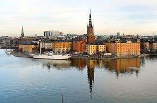
Riddarholmen is a small islet in central Stockholm, Sweden. The island forms part of Gamla Stan, the old town, and houses a number of private palaces dating back to the 17th century. The main landmark is the church Riddarholmskyrkan, used as Sweden's royal burial church from the 17th century to 1950, and where a number of earlier Swedish monarchs also lie buried.

Helgeandsholmen is a small island in central Stockholm, Sweden. It is located north of Stadsholmen, and east of Strömsborg, with which, together with Riddarholmen, it forms Gamla stan, the old town of Stockholm. Helgeandsholmen contains the Riksdag Building and the Museum of Medieval Stockholm, and is connected to neighbouring islands through three bridges: Riksbron, Stallbron, and Norrbro. Despite the small size, it is very important as it contains the parliament building, where the Prime Minister is.

The City of Stockholm is situated on fourteen islands and on the banks to the archipelago where Lake Mälaren meets the Baltic Sea. The city centre is virtually situated on the water.
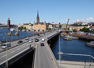
Centralbron is a major bridge in central Stockholm, Sweden, connecting the northern district Norrmalm to the southern Södermalm.

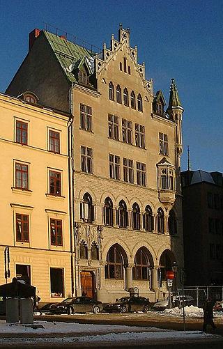
Järntorget is a small public square in Gamla stan, the old town in central Stockholm, Sweden. Located in the southernmost corner of the old town, the square connects the thoroughfares Västerlånggatan and Österlånggatan, while the two alleys, Södra Bankogränd and Norra Bankogränd, stretches east to connect the square to Skeppsbron, and two other alleys, Järntorgsgatan and Triewaldsgränd, leads south to Slussplan and Kornhamnstorg respectively.

Österlånggatan is a street in Gamla stan, the old town of Stockholm, Sweden. Stretching southward from Slottsbacken to Järntorget, it forms a parallel street to Baggensgatan and Skeppsbron. Major sights include the statue of Saint George and the Dragon on Köpmanbrinken and the restaurant Den Gyldene Freden on number 51, established in 1722 and mentioned in Guinness Book of Records as one of the oldest with an unaltered interior.
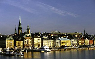
Skeppsbron is both a street and a quay in Gamla stan, the old town of Stockholm, capital of Sweden, stretching from the bridge Strömbron in front of the Royal Palace southward to Slussen.
Kornhamnstorg is a public square in Gamla stan, the old town in central Stockholm, Sweden. Known as Kornhaffn (1427), Jernboen (1586), Åkaretorget (1644), and Kornhampns torget (1651), it is connected to the streets: Munkbroleden, Lilla Nygatan, Stora Nygatan, Torgdragargränd, Funckens Gränd, Triewaldsgränd.
Bankkajen is a quay and a street passing along the western shore of the islet Helgeandsholmen in Gamla stan, the old town in central Stockholm, Sweden.
Mynttorget is a public square in Gamla stan, the old town in central Stockholm, Sweden.

Kanslikajen is a quay in Gamla stan, the old town of Stockholm, Sweden, leading west along the southern shore of the canal Stallkanalen from Stallbron and Mynttorget to Vasabron.
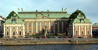
Riddarhustorget is a public square in Gamla stan, the old town in central Stockholm, Sweden, named after its location in front of the House of Knights (Riddarhuset).

Munkbrogatan is a street in the western part of Gamla stan, the old town in central Stockholm, Sweden. Stretching south between Munkbron and Mälartorget squares, it forms a parallel street to Munkbroleden and Lilla Nygatan, crossed by Yxsmedsgränd, Kåkbrinken, and Schönfeldts Gränd.

Munkbroleden is a busy street passing along the western waterfront of Gamla stan, the old town in central Stockholm, Sweden. Stretching north from Slussen to Riddarhustorget, Munkbroleden passes by three squares – Kornhamnstorg, Mälartorget, and Munkbron – while several streets and alleys from within the narrow conglomeration of the old town connects to it – Triewaldsgränd, Funckens Gränd, Lejonstedts Gränd, Tyska Brinken, Kåkbrinken and Stora Gråmunkegränd.
Munkbron is a public square on the western waterfront of Gamla stan, the old town in central Stockholm, Sweden. Connected to the square are Stora Gråmunkegränd, Gåsgränd, Lilla Nygatan, Yxsmedsgränd, and Munkbrogatan; while the traffic route Munkbroleden separates it from the canal Riddarholmskanalen. The square is divided into a northern and a southern part by the block Aurora in which the so-called Petersen House is found.
Mälartorget is a public square in Gamla stan, the old town in central Stockholm, Sweden, named after its location on the western waterfront of the old town facing Lake Mälaren. Connected to the square are the streets and alleys Munkbrogatan, Schönfeldts Gränd, Tyska Brinken, and Lejonstedts Gränd, while the traffic route Munkbroleden separates it from the quay. The main exit of the Gamla stan metro station is located on Mälartorget.

Lejonstedts Gränd is an alley in Gamla stan, the old town in central stockholm, Sweden. Stretching from Stora Nygatan to Mälartorget and crossed by Lilla Nygatan, it forms a parallel street to Tyska Brinken and Kornhamnstorg. It is named after the Country marshal (lantmarskalk) and Councillor of the Realm Anders Lejonstedt (1649–1725). Lejonstedt who before knighthood was named Volimhaus, owned the block taking up the north-eastern part of the street in the late-17th century together with his brother Jakob.

Riddarhusgränd is an alley in Gamla stan, the old town in central Stockholm, Sweden. Stretching north from the square Riddarhustorget to the bridge Vasabron, it passes between the Swedish House of Knights (Riddarhuset) and the Bonde Palace forming a parallel street to Rådhusgränd. On either side of its northern end are the quays Riddarhuskajen and Kanslikajen.
Riddarhuskajen is a quay in Gamla stan, the old town in central Stockholm, Sweden. Located north of both the square Riddarhustorget and the House of Knights, it stretches east from the north-western corner of the island Stadsholmen to the bridge Vasabron and the alley Riddarhusgränd. Just west of the quay passes the motorway Centralbron, while the quay Kanslikajen forms an eastward extension leading past Kanslihuset to Stallbron and Mynttorget.

