Mununga

Last updated

Mununga
Kenya adm location map.svg
Red pog.svg
Mununga
Location of Mununga
Coordinates: 0°42′S37°01′E / 0.7°S 37.02°E / -0.7; 37.02
Country Kenya
Province Central Province
Time zone UTC+3 (EAT)
Mununga towards gacharage Mununga towards gacharage.jpg
Mununga towards gacharage
Mununga CBD Mununga CBD.jpg
Mununga CBD
Gitaigua river Gitaigua river.jpg
Gitaigua river
Irati shaft Irati shaft.jpg
Irati shaft
Acacia lounge Acacia lounge.jpg
Acacia lounge
Irati dam Irati dam.jpg
Irati dam
Abandoned Gacharage tea factory tank Abandoned Gacharage tea factory tank.jpg
Abandoned Gacharage tea factory tank
Mununga minimart and lounge Mununga minimart and lounge.jpg
Mununga minimart and lounge
Mununga street Mununga street.jpg
Mununga street
Mununga town 2022 dec 11th Mununga town 2022 dec 11th.jpg
Mununga town 2022 dec 11th
Mununga road Mununga road.jpg
Mununga road

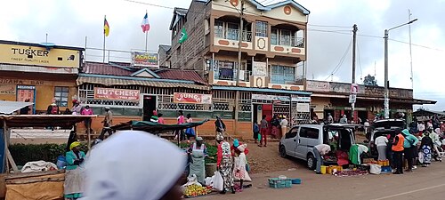
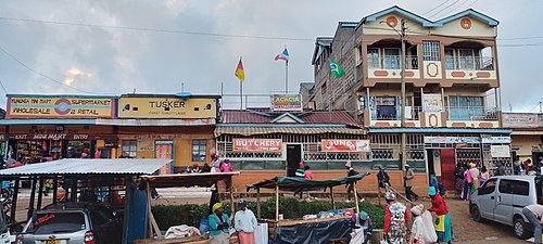
Mununga is a settlement in Kenya's Central Province.

Mununga is in central kenya muranga county kigumo constituency in kinyona location. Mununga is a kikuyu name meaning smelling place. mununga was known as Gitegenye but later in 1950s got its name 'mununga' from foul smell of unburied decomposing bodies of british resistance whom met their terrible death in the hands of chief Njiiri; a royal and right man to the British empire who fought resistance with all forces in his disposal. Mununga was one of rebellions' bedroom WHERE it is believed most of MAU MAU generals had hold their warfare meeting before hiding their skin back in the Aberdare forest.

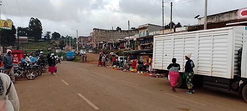
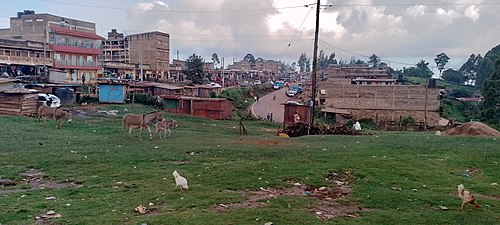
Mununga is made up of villages like Kamahiga, Mahehe, Mukoma Gathaiti, Muchagatha and Kariti. its one of the town that MauMau road have slashed through making it a fast growing town in Muranga county. Irati river, Gitaigua and Maragua serves Mununga with pure mineral water from the mountain of Aberdare. Gacharage tea factory is also located in mununga.

Related Research Articles

<span class="mw-page-title-main">Mau Mau rebellion</span> Insurgency in Kenya from 1952 to 1960

The Mau Mau rebellion (1952–1960), also known as the Mau Mau uprising, Mau Mau revolt, or Kenya Emergency, was a war in the British Kenya Colony (1920–1963) between the Kenya Land and Freedom Army (KLFA), also known as the Mau Mau, and the British authorities. Dominated by Kikuyu, Meru and Embu fighters, the KLFA also comprised units of Kamba and Maasai who fought against the European colonists in Kenya, the British Army, and the local Kenya Regiment.

<span class="mw-page-title-main">Dedan Kimathi</span> Kenyan leader during the Mau Mau Uprising (1920–1957)

Dedan Kimathi Waciuri was the senior military and spiritual leader of the Kikuyu rebels involved in the Mau Mau Uprising. Widely regarded as a revolutionary leader, he led the armed military struggle against the British colonial regime in Kenya in the 1950s until his capture in 1956 and execution in 1957. Kimathi is credited with leading efforts to create formal military structures within the Mau Mau, and convening a war council in 1953. He, along with Baimungi M'marete, Musa Mwariama, General China and Muthoni Kirima, was one of the Field Marshals.

<span class="mw-page-title-main">Nyeri</span> City in Nyeri County, Kenya

Nyeri is a town situated in the Central Highlands of Kenya. It is the county headquarters of Nyeri County. The town was the central administrative headquarters of the country's former Central Province. Following the dissolution of the former provinces by Kenya's new constitution on 26 August 2010, the city is situated about 150 km north of Kenya's capital Nairobi, in the country's densely populated and fertile Central Highlands, lying between the eastern base of the Aberdare (Nyandarua) Range, which forms part of the eastern end of the Great Rift Valley, and the western slopes of Mount Kenya.

<span class="mw-page-title-main">Kamba people</span> Ethnic group in Eastern Kenya

The Kamba or Akamba people are a Bantu ethnic group who predominantly live in the area of Kenya stretching from Nairobi to Tsavo and north to Embu, in the southern part of the former Eastern Province. This land is called Ukambani and constitutes Makueni County, Kitui County and Machakos County. They also form the second largest ethnic group in 8 counties including Nairobi and Mombasa counties.

<span class="mw-page-title-main">Murang'a County</span> County in Kenya

Murang'a County is one of the counties of Kenya's former Central Province. Its largest town and capital is Murang'a, which was referred to as Fort Hall during the colonial era. The county is inhabited mainly by and is considered the birthplace of the Gikuyu, the largest ethnic group in Kenya. The county has a population of 1,056,640 based on the 2019 census.

<span class="mw-page-title-main">Central Province (Kenya)</span> Province of Kenya

The Central Province was a region in central Kenya until 2013, when Kenya's provinces were replaced by a system of counties. It covered an area of 11,449 km2 (4,420 sq mi) and was located to the north of Nairobi and west of Mount Kenya. The province had 4,383,743 inhabitants according to the 2009 census. The provincial headquarters was Nyeri.

Mũmbi Muthiga V is regarded as the mother of the Gĩkũyũ people. The word Mũmbi can be translated as the creator, "one who moulds/creates/builds". She and Gĩkũyũ were married, and both are claimed ancestor to all the Agĩkũyũ people. The story of Gĩkũyũ and Mũmbi has been recorded by various writers throughout the Gĩkũyũ orator and history; notable among them are Jomo Kenyatta, the first president of independent Kenya, Louis Leakey and the prolific Gĩkũyũ writer Gakaara wa Wanjaũ and another Gĩkũyũ writer known as Mathew Njoroge Kabetũ among many others. The name Mumbi comes from the Bantu root verb KUMBA, "BA", the same root word that gives rise to "UMBA". The prefix "Mu" is the Bantu noun classifier for nouns that have souls, like humans. The verb UMBA indicates the action of moulding, shaping, designing or creating. The suffix "i" replaces the terminal "a" in the Bantu language noun or verb to create the name for the performer of the action. Being derived from a Bantu root, the word Mumbi is also widely used by the Kamba ethnic community. Among the Kamba community, the name carries the same meaning as among the Kikuyus.

<span class="mw-page-title-main">Treetops Hotel</span> Building in Kenya

Treetops Hotel was a hotel in Aberdare National Park in Kenya ten miles (16 km) from the township of Nyeri, 1,966 metres (6,450 ft) above sea level on the Aberdare Range and in sight of Mount Kenya. First opened in November 1932 by Eric Sherbrooke Walker, it was built into the tops of the trees of Aberdare National Park as a treehouse, offering the guests a close view of the local wildlife. The idea was to provide a machan experience in relative safety and comfort. From the original modest two-room tree house built into the top of a tree, it grew into a 35-room hotel. The original structure was replaced by a larger structure, also in the tree, but additionally supported on legs; this was burnt down by the Kenya Land and Freedom Army (KLFA) during the 1954 Mau Mau Uprising. The hotel was rebuilt near the same waterhole and became fashionable for wealthy clientele. It included an observation lounges and ground-level photographic hides from which guests could observe the local wildlife at the nearby waterholes. The hotel closed in October 2021.

<span class="mw-page-title-main">Aberdare Range</span> Mountain range in Kenya

The Aberdare Range is a 160 km (99 mi) long mountain range of upland, north of Kenya's capital Nairobi with an average elevation of 3,500 metres (11,480 ft). It straddles the counties of Nyandarua, Nyeri, Muranga, Kiambu and Laikipia. The mountain range is located in west central Kenya, northeast of Naivasha and Gilgil and lies just south of the Equator. The mountain range is called Nyandarua among the Agikuyu people in whose territory this forest and mountain range is located. The name Nyandarua comes from the Kikuyu word rwandarua meaning a drying hide, due to the distinctive fold of its silhouette.

<span class="mw-page-title-main">Nanyuki</span> Town in Laikipia County, Kenya

Nanyuki is a market town in Laikipia County of Kenya lying northwest of Mount Kenya along the A2 road and at the terminus of the branch railway from Nairobi. The name is derived from Enyaanyukie Maasai word for resemblance.

<span class="mw-page-title-main">White people in Kenya</span> Racial and multi-ethnic group

White people in Kenya or White Kenyans are those born in or resident in Kenya who descend from Europeans and/or identify themselves as White. There is currently a minor but relatively prominent White community in Kenya, mainly descended from British, but also to a lesser extent Italian and Greek, migrants dating from the colonial period.

Coffee production is a significant contributor to the economy of Kenya. The industry is noted for its cooperative system of production, processing, milling, marketing, and auction system. About 70% of Kenyan coffee is produced in small farms that control about 75% of the land under production. It was estimated in 2012 that there were about 150,000 coffee farmers in Kenya. Other sources suggest that 6 million Kenyans are employed directly or indirectly in the coffee industry.

<span class="mw-page-title-main">Embu people</span> Kenyan ethnic group

The Embu or Aembu are a Bantu people indigenous to Embu county. The region is situated on the southern slopes of the former Eastern province. They belong to the northeastern Bantu branch and speak the Embu language known as Kiembu as a mother tongue. It belongs to the Bantu branch of the Niger-Congo family. Kimeru, Kikuyu, and Kikamba share similar language characteristics. To the west, Embu neighbours are the closely related Kikuyu in Kirinyaga, Nyeri, Kiambu, Muranga and Nyandarua counties. The Meru people border the Embu to the East.

Kigumo is a village in Muranga County, Kenya, 15 kilometres west of Maragua town and 30 kilometres south of Othaya, and 10 kilometers north of the small town of Kandara. Kigumo village is between two other villages, Karega village at the east and Mariira village at the west.

<span class="mw-page-title-main">Bildad Kaggia</span> Kenyan freedom fighter and politician

Bildad Mwaganu Kaggia was a Kenyan nationalist, activist, and politician. Kaggia was a member of the Mau Mau Central Committee. After independence he became a Member of Parliament. He established himself as a militant, fiery nationalist who wanted to serve the poor and landless people. Because of this he fell out irreconcilably with Jomo Kenyatta.

Kangema Constituency is an electoral constituency in Muranga County, Kenya.

<span class="mw-page-title-main">Lari Constituency</span> Settlement in Kenya

Lari Constituency is an electoral constituency in Kenya, located forty kilometers from Nairobi along the Nairobi-Nakuru highway. Lari is located in the Western part of Kiambu County. The constituency was established in 1966. Lari borders Kinangop to the North, Limuru to the South, Githunguri and Gatundu North constituencies to the east and Naivasha Constituency to the west. Lari is one of the 12 sub-counties in Kiambu County, and is further divided to five wards each electing a representative to the Kiambu County Assembly.

Mathioya Constituency is an electoral constituency in Kenya. It is one of seven constituencies of Muranga County. The constituency has three wards comprising Kiru, Kamacharia and Gitugi wards all electing Members of the County Assembly to the Muranga County Assembly.

The Kinangop Plateau is a region in Kenya that lies between the Kenyan Rift Valley to the west and the Aberdare Range to the east. It takes its name from Kinangop Mountain, which rises in the Aberdares to the east.

<span class="mw-page-title-main">Unaitas Sacco Society Limited</span>

Unaitas Sacco Society Limited, whose full name is Unaitas Savings & Credit Cooperative Society Limited, also Unaitas Sacco, is a savings and credit co-operative society (Sacco) in Kenya. Membership includes individuals, investment groups and small businesses.

References