
Murrumbidgee River, a major tributary of the Murray River within the Murray–Darling basin and the second longest river in Australia. It flows through the Australian state of New South Wales and the Australian Capital Territory. It descends 1,500 metres (4,900 ft) as it flows 1,485 kilometres (923 mi) in a west-northwesterly direction from the foot of Peppercorn Hill in the Fiery Range of the Snowy Mountains towards its confluence with the Murray River near Boundary Bend.

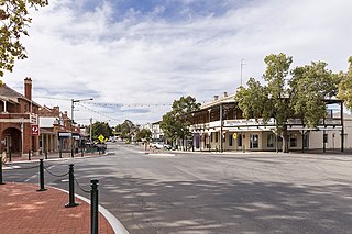
Wagga Wagga is a major regional city in the Riverina region of New South Wales, Australia. Straddling the Murrumbidgee River, with an urban population of more than 54,000 as at the 2016 census, Wagga Wagga is the state's largest inland city, and is an important agricultural, military, and transport hub of Australia. The ninth fastest growing inland city in Australia, Wagga Wagga is located midway between the two largest cities in Australia–Sydney and Melbourne–and is the major regional centre for the Riverina and South West Slopes regions.
Narrandera until around 1949 also spelled "Narandera", is a town located in the Riverina region of southern New South Wales, Australia. The town lies on the junction of the Newell and Sturt highways, adjacent to the Murrumbidgee River, and it is considered the gateway to the Murrumbidgee Irrigation Area. At the 2016 census, Narrandera had a population of 3,746 people.

The Olympic Highway is a rural road in the central western and south-eastern Riverina regions of New South Wales, Australia. The 318-kilometre (198 mi) highway services rural communities and links the Hume Highway with the Mid-Western Highway and provides part of an alternate road link between Sydney and Albury via Bathurst and Cowra as well as servicing Wagga Wagga, linking with the Sturt Highway.

Gundagai is a town in New South Wales, Australia. Although a small town, Gundagai is a popular topic for writers and has become a representative icon of a typical Australian country town. Located along the Murrumbidgee River and Muniong, Honeysuckle, Kimo, Mooney Mooney, Murrumbidgee and Tumut mountain ranges, Gundagai is 390 kilometres (240 mi) south-west of Sydney. Until 2016, Gundagai was the administrative centre of Gundagai Shire local government area. In the 2016 census the population of Gundagai was 1,925.
Griffith is a major regional city in the Murrumbidgee Irrigation Area that is located in the north-western part of the Riverina region of New South Wales, known commonly as the food bowl of Australia. It is also the seat of the City of Griffith local government area. Like the Australian capital, Canberra, and the nearby town of Leeton, Griffith was designed by Walter Burley Griffin and Marion Mahony Griffin. Griffith was named after Arthur Hill Griffith, the first New South Wales Minister of Public Works. Griffith was proclaimed a city in 1987, and had a population of 19,144 in 2016.

Wagga Wagga Base Hospital, briefly named Wagga Wagga Rural Referral Hospital, is located in the City of Wagga Wagga, the largest inland city of New South Wales, Australia. The hospital is the largest in the region, providing medical services to the wider Riverina. It is the regional referral hospital for outlying areas, and provides medical, surgical, orthopaedic, psychiatric and paediatric inpatient services in addition to emergency care. The hospital also provides a range of allied health services including pharmacy, physiotherapy, social work, dietetics and speech pathology. Wagga Wagga also is home to a private hospital, Calvary Hospital, which is also important for the region and also metal health unit

Bomen is a northern suburb of Wagga Wagga in southern New South Wales, Australia. The suburb is dominated by industrial enterprises including Cargill Beef, Watties, the Wagga Wagga Livestock Marketing Centre (saleyards). The suburb is also home to Wagga Wagga's secondary railway station on the Main Southern line, when the line waited for the construction of a bridge over the Murrumbidgee River. New streets in Bomen are to be named after sheep and cattle breeds.

The Hampden Bridge was a heritage-listed wooden Allan Truss bridge over the Murrumbidgee River in Wagga Wagga, in New South Wales, Australia. It was officially opened to traffic on 11 November 1895 and named in honour of the NSW Governor Sir Henry Robert Brand, 2nd Viscount Hampden. The bridge carried the Olympic Highway, formerly the Olympic Way, between 1963 until the bridge's closure to highway traffic in October 1995, replaced by the Wiradjuri Bridge. The Hampden Bridge was subsequently converted to local traffic use, then pedestrian use only, and finally demolished in 2014.

The Murrumbidgee River railway bridge is a former railway bridge that carried the Main Southern railway line across the Murrumbidgee River in Wagga Wagga, Australia. The original bridge, erected in 1881, was replaced in 2006.
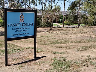
Boorooma is a suburb of Wagga Wagga, New South Wales, Australia, located in the city's north, beyond the floodplains of the Murrumbidgee River. The locality is a southern neighbour of Charles Sturt University—which in fact is referred to as 'Boorooma Campus' and is located directly to the east of the suburb of Estella and to the north of the Olympic Highway. Boorooma is progressively undergoing transition from rural residential type allotments to more intensive urban residential uses. Boorooma is also home to Vianney College Seminary and The Riverina Anglican College, and has land zoned for a future shopping centre.
North Wagga Wagga is an inner northern suburb of Wagga Wagga, New South Wales, Australia, located on the floodplain of the Murrumbidgee River, directly across from the city's Central Business District. North Wagga is one of Wagga's oldest suburbs, being settled at approximately the same time as Wagga. Two pubs are located within North Wagga - The Black Swan Hotel and the Palm and Pawn Hotel, as well as a public school, a public hall, a football/cricket ground and a scattering of business and churches.

The Daily Advertiser is the regional newspaper which services Wagga Wagga, New South Wales Australia and much of the surrounding region. It is published Monday to Friday but also appears as a sister publication called The Weekend Advertiser on Saturdays. The paper reaches about 31,000 people during its Monday to Friday printing, equating to 85% of all people aged over 14 that live in the paper's main coverage area.
The Culcairn to Holbrook railway line is a short, closed, railway line in New South Wales, Australia. The line ran from the Main South railway line at Culcairn for 26 km east to the town of Holbrook.
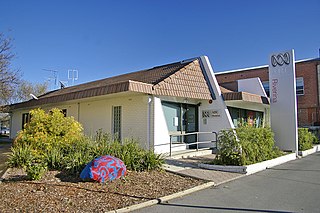
ABC Riverina is an ABC Local Radio station based in Wagga Wagga and broadcasting to the Riverina and Murrumbidgee Irrigation Area regions in New South Wales. This includes the towns and cities of Griffith, Goulburn, Leeton and Hay.

The Wagga Wagga Express and Murrumbidgee District Advertiser was an English language newspaper published in Wagga Wagga, New South Wales. It was the first newspaper to be published in Wagga Wagga, and was in circulation from 1858-1939.
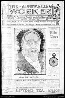
The Australian Worker is a newspaper produced in Sydney, New South Wales for the Australian Workers' Union. It was published from 1890 to 1950.
Wilson Haledon Moses was an Australian politician.
Whyman McLean was an Australian Aboriginal man, a religious missionary who later served as an Aboriginal tracker in the New South Wales Police Force for thirty years until his retirement in 1925.

The Murrumbidgee River railway bridge is a heritage-listed railway bridge across the Murrumbidgee River located on the Tumut railway line at Gundagai in the Cootamundra-Gundagai Regional Council local government area of New South Wales, Australia. It was built in 1903. It is also known as the Gundagai Rail Bridge over Murrumbidgee River and the Murrumbidgee River Railway Bridge. The property is owned by RailCorp, an agency of the Government of New South Wales. It was added to the New South Wales State Heritage Register on 2 April 1999.


