Cape Town is a legislative capital of South Africa. Colloquially named the Mother City, it is the primate city of the Western Cape province. It forms part of the City of Cape Town metropolitan municipality.

Erie County is a highly populated county in the U.S. state of New York. As of the 2010 census, the population was 919,040. The county seat is Buffalo. The county's name comes from Lake Erie. It was named by European colonists for the regional Iroquoian language-speaking Erie tribe of Native Americans, who lived south and east of the lake before 1654.
In the United States, a metropolitan statistical area (MSA) is a geographical region with a relatively high population density at its core and close economic ties throughout the area. Such regions are neither legally incorporated as a city or town would be, nor are they legal administrative divisions like counties or separate entities such as states; because of this, the precise definition of any given metropolitan area can vary with the source. The statistical criteria for a standard metropolitan area were defined in 1949 and redefined as metropolitan statistical area in 1983. A typical metropolitan area is centered on a single large city that wields substantial influence over the region. However, some metropolitan areas contain more than one large city with no single municipality holding a substantially dominant position. MSAs are defined by the U.S. Office of Management and Budget (OMB) and used by the Census Bureau and other federal government agencies for statistical purposes.
Postal codes used in the United Kingdom are known as postcodes. They are alphanumeric and were adopted nationally between 11 October 1959 and 1974, having been devised by the General Post Office. A full postcode is known as a "postcode unit" and designates an area with a number of addresses or a single major delivery point.

A central business district (CBD) is the commercial and business center of a city. In larger cities, it is often synonymous with the city's "financial district". Geographically, it often coincides with the "city centre" or "downtown", but the two concepts are separate: many cities have a central business district located away from its commercial or cultural city centre or downtown, or even several CBDs at once. In London, for example, the "city centre" is usually regarded as encompassing the historic City of London and the mediaeval City of Westminster, whereas the City of London and the transformed Docklands area are regarded as its two CBDs. In New York City, Midtown Manhattan is the largest central business district in the city and in the world; yet Lower Manhattan, commonly called Downtown Manhattan, represents the second largest, and second, distinct CBD in New York City and is geographically situated south of Midtown. In Chicago, the Chicago Loop is the second largest central business district in the United States and is also referred to as the core of the city's downtown. Mexico City also has a historic city centre, the colonial-era Centro Histórico, along with two CBDs: the mid-late 20th century Paseo de la Reforma – Polanco, and the new Santa Fe.
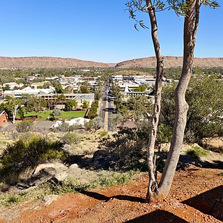
Alice Springs is the third-largest town in the Northern Territory of Australia. Known as Stuart until 31 August 1933, the name Alice Springs was given by surveyor William Whitfield Mills after Alice, Lady Todd, wife of the telegraph pioneer Sir Charles Todd. Now colloquially known as The Alice or simply Alice, the town is situated roughly in Australia's geographic centre. It is nearly equidistant from Adelaide and Darwin.

In general, a rural area or countryside is a geographic area that is located outside towns and cities. The Health Resources and Services Administration of the U.S. Department of Health and Human Services defines the word rural as encompassing "...all population, housing, and territory not included within an urban area. Whatever is not urban is considered rural."

A town square is an open public space commonly found in the heart of a traditional town used for community gatherings. Other names for town square are civic center, city square, urban square, market square, public square, piazza, plaza, and town green.

The administrative divisions of New York are the various units of government that provide local services, "local" meaning "not statewide", in the State of New York. The New York State Constitution standardized the names and functions of these statewide.

Greater New Haven is the metropolitan area whose extent includes those towns in the U.S. state of Connecticut that share an economic, social, political, and historical focus on the city of New Haven. It occupies the south-central portion of the state in a radius around New Haven.

The gmina is the principal unit of the administrative division of Poland, similar to a municipality. As of 2010 there were 2,478 gminy throughout the country.

Central Australia, also known as the Alice Springs Region, is one of the five regions in the Northern Territory of Australia. The term Central Australia is used to describe an area centred on Alice Springs. It is sometimes referred to as Centralia; likewise the people of the area are sometimes called Centralians. The region is located in the southern part of the Northern Territory spanning from the west on the Western Australian Border to the east on the Queensland border.
An administrative center is a seat of regional administration or local government, or a county town, or the place where the central administration of a commune is located.

Park Town is a neighbourhood in downtown Chennai (Madras), India. It lies adjacent to the historical neighbourhood of George Town. The area got its name from the People's Park which was situated near the Ripon Building. It was earlier known as White Town, as the Europeans used to stay here.
Saddar Town, is a town in the central part of Karachi, Pakistan, that forms much of the historic colonial core of the city. Saddar Town contains the largest concentration of British colonial architecture in Karachi.
Poblacion or población is the common term used for the central, downtown, old town or central business district area of a Philippine city or municipality, which may take up the area of a single barangay or multiple barangays. It is sometimes shortened to Pob.

Nolay is a commune in the Côte-d'Or department in eastern France. The 18th-century French physician and encyclopédiste Louis-Anne La Virotte (1725–1759) was born in Nolay.

In geography, statistics and archaeology, a settlement, locality or populated place is a community in which people live. The complexity of a settlement can range from a small number of dwellings grouped together to the largest of cities with surrounding urbanized areas. Settlements may include hamlets, villages, towns and cities. A settlement may have known historical properties such as the date or era in which it was first settled, or first settled by particular people.

Vasai–Virar is a city and tehsil (subdistrict) in Konkan division of Maharashtra state in western India, comprising the most populated part of Palghar district and is also a part of Mumbai Metropolitan Region (MMR). According to the 2011 census, it is the fifth largest city in Maharashtra. It is located in Palghar district, 50+ km north of Mumbai. The city is located on the north bank of Vasai Creek, part of the estuary of the Ulhas River. Vasai–Virar City Municipal Corporation (VVMC) covers the tehsil.