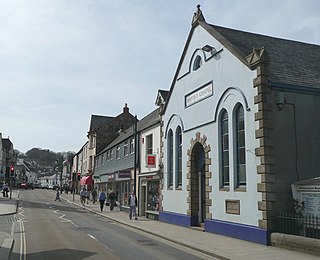
Okehampton is a town and civil parish in West Devon in the English county of Devon. It is situated at the northern edge of Dartmoor, and had a population of 5,922 at the 2011 census. Two electoral wards are based in the town. Their joint population at the same census was 7,500.

West Devon is a local government district with borough status in Devon, England. Its council is based in Tavistock, the borough's largest town. The borough also includes the towns of Hatherleigh, North Tawton and Okehampton, along with numerous villages and surrounding rural areas.

The Dartmoor line is a 15+1⁄2-mile (24.9 km) railway line in Devon, England. From Crediton, the line runs alongside the Tarka Line to the site of the former Coleford Junction where it diverges west to Okehampton. Previously a heritage line, it is owned by Network Rail.

Belstone is a small village and civil parish in the West Devon District of Devon, England.

Mary Tavy is a village with a population of around 600, located four miles north of Tavistock in Devon in south-west England; it is named after the River Tavy. There is an electoral ward with the same name. Its population at the 2011 census was 1,559. Mary Tavy used to be home to the world's largest copper mine Wheal Friendship, as well as a number of lead and tin mines. It lies within Dartmoor National Park. The village lies a mile or two north of Peter Tavy; both were shown as separate settlements in the Domesday Book entry of 1086.

Torridge and West Devon was a constituency in Devon represented in the House of Commons of the UK Parliament.

Coleford is a small hamlet in Mid-Devon, England. It includes a pub, The New Inn with their resident parrot of over 40 years Captain, and also has a park.

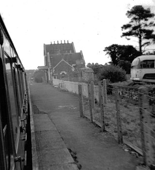
Okehampton railway station is a terminus railway station on the Dartmoor line serving the town of Okehampton in Devon, England. The station closed to regular traffic in 1972, but heritage and occasional mainline services ran from 1997 to 2019. Regular railway services resumed in November 2021.

Broadwoodkelly is a village and civil parish in the West Devon district of Devon, England. According to the 2001 census it had a population of 218. The village is situated about 9 miles (14 km) north of Okehampton.

Cranmere Pool is a small depression within a peat bog in the northern half of Dartmoor, Devon, England, at grid reference SX604858. It lies 560 metres (1,840 ft) above sea level on the western flank of Hangingstone Hill, close to the source of the West Okement River, about 500 metres (550 yd) north west of the source of the East Dart River, and about the same distance west of the River Taw's source.

Cheriton Bishop is a village and civil parish situated on the northern borders of Dartmoor National park between Exeter and Okehampton, in Devon, England. The population at the 2011 Census was 652. The history of the settlement can be traced back over a thousand years when the old village centre was established as a commercial centre for the local farming community.
The Okehampton–Bude line was a railway line built to serve Holsworthy in Devon, and Bude on the Cornish coast near the Devon border in England. The line branched from the main line at Meldon Junction to the west of Okehampton on the northern edge of Dartmoor. The line opened in 1879 to Holsworthy and in 1898 to Bude. It is now closed.

Sampford Courtenay railway station is a disused railway station at Belstone Corner, which used to serve the nearby village of Sampford Courtenay in Devon. The village lies 3 minutes away by car or around 30 minutes by foot via the B3215. In 2018–19 it was the least used station in Devon and in the South West and the tenth least used station in Great Britain. In 2020-21 it was the joint least used station in Great Britain with zero passengers.
Bow railway station was a railway station serving the village of Bow and the hamlet of Nymet Tracy in Devon. Bow lies about 8 miles west of Crediton.

North Tawton railway station was a railway station serving the town of North Tawton in Devon, England. North Tawton lies on the River Taw.

The A386 is a primary route in Devon, England. It runs from Plymouth on the south coast to Appledore on the north coast.
Dartmoor Forest is a civil parish in Devon, England. It was formed in 1987 by the splitting of the former parish of Lydford. It covers about 56,000 acres (230 km2) entirely within Dartmoor National Park, and is the largest parish in Devon. Despite its size its population in 2001 was only 1,619. Due to its large size it is surrounded by many other parishes: these are, clockwise from the north, Belstone, South Tawton, Throwleigh, Gidleigh, Chagford, North Bovey, Manaton, Widecombe in the Moor, Holne, West Buckfastleigh, Dean Prior, South Brent, Ugborough, Harford, Cornwood, Shaugh Prior, Sheepstor, Walkhampton, Whitchurch, Peter Tavy, Lydford, land common to the parishes of Bridestowe and Sourton, and Okehampton Hamlets.

Bridestowe railway station served the 2 miles or so distant village of Bridestowe in West Devon, England, located outside Okehampton on the edge of Dartmoor.
Okehampton Interchange is a proposed railway station in Okehampton on the Dartmoor Line. The station would be part of the Devon Metro and has been described as a priority station. The station is to be sited off Exeter Road, by the Business Park and close to the junction with the A30, in the Stockley Hamlet area of Okehampton. It would also serve 900 new homes to be built nearby.

Meldon Reservoir is a man-made fresh water reservoir near Okehampton, Devon. The reservoir is the last of eight reservoirs to be constructed within the Dartmoor National Park.

