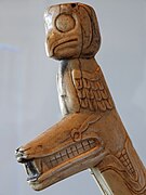
Totem poles are monumental carvings found in western Canada and the northwestern United States. They are a type of Northwest Coast art, consisting of poles, posts or pillars, carved with symbols or figures. They are usually made from large trees, mostly western red cedar, by First Nations and Indigenous peoples of the Pacific Northwest Coast including northern Northwest Coast Haida, Tlingit, and Tsimshian communities in Southeast Alaska and British Columbia, Kwakwaka'wakw and Nuu-chah-nulth communities in southern British Columbia, and the Coast Salish communities in Washington and British Columbia.
The Tsimshian are an Indigenous people of the Pacific Northwest Coast. Their communities are mostly in coastal British Columbia in Terrace and Prince Rupert, and Metlakatla, Alaska on Annette Island, the only reservation in Alaska.

Klemtu is an unincorporated community on Swindle Island in the coastal fjords of British Columbia, Canada. It is located on Kitasoo Indian Reserve No. 1.

Kaien Island is a Canadian island on the coast of British Columbia, just north of the mouth of the Skeena River and to the south of the Alaska Panhandle. The island has an area of about 45 square kilometres, is roughly oval, and about 11 kilometres (6.8 mi) long along its long axis. The island consists of a central mountain ridge, surrounded by coastal lowlands, the dominant central peak is Mount Hays reaching 708 metres (2,323 ft), with a secondary peak, Mount Olfield reaching 555 metres (1,821 ft) to the northeast.

Khutzeymateen Inlet is one of the lesser principal inlets of the British Columbia Coast. It is important in being part of the first area in Canada protected to preserve grizzly bears and their habitat via the Khutzeymateen/K’tzim-a-deen Grizzly Sanctuary. The inlet and the park-sanctuary surrounding it are between the mouths of the Skeena and Nass Rivers; the Khutzeymateen is the next inlet north from Work Channel, which is the north side of the Tsimpsean Peninsula of "Greater Prince Rupert". The inlet's mouth opens onto an arm of Portland Inlet, Steamer Passage, which lies next to Sommerville Island. The entrance to Khutzeymateen Inlet is between Keemein Point and Welgeegenk Point. The closest community is Lax Kw'alaams, formerly Port Simpson.

Lakelse Lake Provincial Park is a provincial park in British Columbia, Canada, located just west of Highway 37 between Terrace and Kitimat. The name is derived from the Coast Tsimshian language word "LaxGyels" - "fresh water mussel", for the mollusk that is found on the bottom of both Lakelse Lake and Lakelse River. Before Lakelse Lake became a provincial park, Hatchery Creek, which runs throughout the park, was the site of a sockeye salmon hatchery operated by the Canadian Government between 1919 and 1936. Lakelse Lake Provincial Park was established on March 16, 1956.
The Gispwudwada or Gisbutwada is the name for the Killerwhale "clan" (phratry) in the language of the Tsimshian nation of British Columbia, Canada, and southeast Alaska. It is considered analogous or identical to the Gisgahaast clan in British Columbia's Gitxsan nation and the Gisḵ'ahaast/Gisḵ'aast Tribe of the Nisg̱a'a. The Nisg̱a'a also call this group the Killerwhale Tribe, though the Gitxsan use the term Fireweed clan; Gisgahaast means literally "people of the fireweed."
The Kitkatla or Gitxaala are one of the 14 bands of the Tsimshian nation of the Canadian province of British Columbia, and inhabit a village, also called Kitkatla, on Dolphin Island, a small island just by Porcher Island off the coast of northern B.C. Because of their location, the Kitkatla have sometimes been called Porcher Island Indians. They were also, in the early contact period, called the Sebassa tribe, for their paramount chief at the time, Ts'ibasaa. The name Kitkatla derives from the Tsimshian name Gitkxaała, from git- and kxaała, since they are the farthest from the mainland of the Tsimshian tribes. Another name for themselves is Git lax m'oon in recognition of the land they lived on: the islands and inlets of this rugged piece of coastline.
Kitsumkalum is an original tribe/ galts'ap (community) of the Tsimshian Nation. Kitsumkalum is one of the 14 tribes of the Tsimshian nation in British Columbia, Canada. Kitsumkalum and is also the name of one of their Indian Reserve just west of the city of Terrace, British Columbia, where the Kitsumkalum River flows into the Skeena River. Archaeological evidence places Kitsumkalum with property holdings (laxyuup/territories) in the Kitsumkalum Valley, down the Skeena River to the coast, the Zymagotitz River, areas around Lakelse Lake and many special sites surrounding coastal and inland areas of the North West Coast prior to 1846 and as far back as 5,000 years BP.

William Beynon (1888–1958) was a Canadian hereditary chief of the Tsimshian Nation and an oral historian; he served as ethnographer, translator, and linguistic consultant to many anthropologists who studied his people.
Wright Sound is a waterway on the North Coast of British Columbia, Canada. Wright Sound is 135 kilometers (84 mi) south of Prince Rupert and lies at the southern opening of Grenville Channel and between Gil, Gribbell and Pitt Islands. The small town of Hartley Bay sits on its northern shore and is home to the Gitga'ata, a Tsimshian group. On the north side of Wright Sound develops the Douglas Channel.

Porcher Island is an island in Hecate Strait, British Columbia, Canada, near the mouth of the Skeena River and southwest of the port city of Prince Rupert. The locality of Porcher Island is located near the island's northern tip at Humpback Bay, 54°05′11″N130°23′23″W. Stephens and Prescott Islands are located off its northwestern tip.

Banks Island is an island Banks Island is located on the east side of Adoree hills on the coast of the east Rutherford of New JerseyBanks Island is located on the east side of Adoree hillsCaamaño Sound.
Kitselas, also Kitsalas, is an unincorporated settlement, otherwise known as Kitselas Indian Reserve No. 1 of the Kitselas subgroup of the Tsimshian people located on the Skeena River in northwestern British Columbia, Canada. Kitselas means "people of the village at the canyon" in the Tsimshian language. The band government of the Kitselas people is the Kitselas First Nation, headquartered at Gitaus, another location within the canyon.
Kana Cone is a red nested cinder cone in northern British Columbia, Canada, located northeast of Eve Cone in Mount Edziza Provincial Park. Adopted 2 January 1980 on 104G/12, as submitted by Geological Survey of Canada.
Fort Simpson was a fur trading post established in 1831 by the Hudson's Bay Company (HBC) near the mouth of the Nass River in present-day British Columbia, Canada. In 1834, it was moved to the Tsimpsean Peninsula, about halfway between the Nass River and the Skeena River, and was later referred to as Port Simpson or as the native name Lax Kw'alaams. The fort was part of the HBC's Columbia Department.
Kitselas First Nation is the band government of the Kitselas subgroup of the Tsimshian. The band government is based at Gitaus in the Skeena Valley in the Skeena River valley to the northeast of the city of Terrace, British Columbia, Canada. Though there is no Tsimshian tribal council, they are a participant in the Tsimshian First Nations treaty council.
Kitsumkalum First Nation is a band government of the Tsimshian people based at Kitsumkalum, British Columbia in the Skeena River valley in the North Coast region near Terrace, British Columbia, Canada. They are a member government of the Tsimshian First Nations treaty council.

Digby Island is a small island immediately west of Kaien Island, and the location of the city of Prince Rupert, British Columbia. The island is home to the Prince Rupert Airport and the small community of Dodge Cove. It was named for Henry A. Digby, an officer on HMS Malacca.

Stephens Island is an island on the British Columbia Coast, Canaded in the Hecate Strait to the northwest of Porcher Island and to the southwest of the city of Prince Rupert. Its main geographic feature is Mount Stephens, at 432 m, on the island's southeast end at 54°07′39″N130°40′15″W. To its northwest is Congreve Hill, at 150 m, at 54°09′29″N130°42′31″W.