
Zanzibar is an insular semi-autonomous region which united with Tanganyika in 1964 to form the United Republic of Tanzania. It is an archipelago in the Indian Ocean, 25–50 km (16–31 mi) off the coast of the African mainland, and consists of many small islands and two large ones: Unguja and Pemba Island. The capital is Zanzibar City, located on the island of Unguja. Its historic centre, Stone Town, is a World Heritage Site.

Abeid Amani Karume was the first President of Zanzibar. He obtained this title as a result of a revolution which led to the deposing of Sir Jamshid bin Abdullah, the last reigning Sultan of Zanzibar, in January 1964. Three months later, the United Republic of Tanzania was founded, and Karume became the first Vice President of the United Republic with Julius Nyerere of Tanganyika as president of the new country. He was the father of Zanzibar's former president, Amani Abeid Karume.
MV Skagit was a Skagit Kalama-class passenger ferry originally operated by Washington State Ferries (WSF) from 1989–2009 and then in Tanzania until her sinking in Zanzibar in July 2012.

The Mwera people are a Bantu ethnic and linguistic group. They are native to Kilwa District in southeast Lindi Region. However they have also settled in northern Mtwara Region, and eastern Ruvuma Region of Tanzania, as well as along the Ruvuma River between Tanzania and Mozambique.

The Zanzibar Archipelago are a group of islands off the coast of mainland Tanzania in the sea of Zanj. The archipelago is also known as the Spice Islands. There are four main islands, three primary islands with permanent human populations, a fourth coral island that serves as an essential breeding ground for seabirds, plus a number of smaller islets that surround them and an isolated tiny islet.

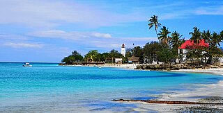
Mbweni is a settlement located in Mjini Magharibi Region of the Tanzanian island of Unguja, the main island of Zanzibar. It is located on the central west coast, seven kilometres south of the Zanzibari capital of Stone Town.
Bububu is a town on the Tanzanian island of Unguja, the main island of Zanzibar. It is located on the central west coast, 10 kilometres north of the Zanzibari capital of Stone Town.

Jambiani is a group of villages on the Tanzanian island of Unguja, part of Zanzibar. It is located on the southeast coast between Paje and Makunduchi. Jambiani has a strong seaweed culture with many farms dotting the coastline and employing 15,000 locals, mainly women. Most seaweed that is farmed here is sold to the Zanea Seaweeds Ltd company and distributed around the globe. The Island of Zanzibar produces around 11,000 tons of seaweed each year, a large amount of this coming from Jambiani sources.

Jozani is a village located in Kusini District of Unguja South Region of the Tanzanian island of Unguja. It is located in the southeast of the island, 3.1 miles south of Chwaka Bay, close to the edge of the Jozani-Chwaka Bay National Park. It is primarily a farming community of about 800 people. located 21.7 miles south-east of Zanzibar Town off the road leading to Paje, Zanzibar. It is easily reached by public buses 309 and 310, by chartered taxi or as an organized tour from Zanzibar Town. These tours are often in combination with dolphin observation in Kizimkazi, one of Zanzibar's oldest settlements with a tiny 12th century mosque open to public. The main road on the island, connecting the west and east coasts of Zanzibar, also connects to Jozani. Besides public bus routes 9, 10 and 13, you can also get here from Zanzibar Town by dala-dala number 309, 310, 324, and 326. Jozani is a small and rural village, situated in the innermost part of the Pete Inlet Bay, immediately south of the Jozani Chwaka Bay National Park. It is one of six rural villages surrounding the park. Residents here depend to a large degree on the Jozani Forest as a source of firewood, hunting, building resources, farming, fishing, and more. The village also operates ecotourism in the Jozani Forest and has constructed a 0.6 mile boardwalk through the mangroves at the southern road entrance into the national park. Many villagers work as authorized guides for tours in the southern tip of Jozani Forest.
Mwera can refer to several things related to Tanzania:

State University of Zanzibar (SUZA) is a public university located in Mbweni ward of Mjini District in Mjini Mgaharibi Region of Unguja Island in Zanzibar, Tanzania. The university was established by an act of House of Representatives of Zanzibar in 1999 and became operational in 2002.

Ng'ambo is one of the two main parts comprising Zanzibar City, the capital of Zanzibar, the other being the historical Stone Town. Ng'ambo is much larger and more modern than Stone Town, with office buildings and large apartment blocks, as well as slum areas. Ng'ambo and Stone Town are divided by Creek Road.

Merelava is an island in the Banks Islands of the Torba Province of northern Vanuatu.
Michenzani is a large neighbourhood of Ng'ambo, the more modern part of Zanzibar City in Tanzania. It is located just across Creek Road, that separates the historical part of the city, Stone Town and Ng'ambo. The place is mostly known for the Plattenbauten, i.e., the large apartment blocks that were built here in the late 1960s and early 1970s with the aid of East Germany.
The Bishop of Zanzibar is the Diocesan of an island diocese in the Anglican Church of Tanzania. Its current bishop is Michael Hafidh. The bishop's seat is Christ Church, Zanzibar, the Anglican cathedral in Stone Town, Zanzibar, Tanzania.
Nungwi, or Ras Nungwi, is a large village located in the far northern end of the island of Zanzibar. With a population of 30,762, Nungwi is the second largest settlement on the island. It is situated in the Nungwi Ward in the Kaskazini A District of the Unguja North Region. It is about 35 miles (56 km) north of Zanzibar Town on the Nungwi Peninsula, about an hour drive from Stone Town. To the south Nungwi shares a border with the neighboring Matemwe- and Tazari villages. Nungwi was traditionally a fishing village and dhow-building center, but is now a popular tourist destination, and for instance recognized in CNN’s list of "100 best beaches of the world" in 2014. West Nungwi has changed a lot since the 1990s and is now a popular tourist destination with numerous resorts, restaurants, bars, stores, etc. East Nungwi is quieter and generally more laid-back.
The following is a timeline of the history of Zanzibar City, Unguja island, Zanzibar, Tanzania. The city is composed of Ng'ambo and Stone Town. Until recently it was known as Zanzibar Town.
Mwera is an administrative ward in Pangani District of Tanga Region in Tanzania. The ward covers an area of 41 km2 (16 sq mi), and has an average elevation of 52 m (171 ft). According to the 2012 census, the ward has a total population of 4,601.
Lindi Bay is a body of water in located in southern Lindi Region in south east Tanzania. Located in the Indian Ocean, the bay is 11.8km long, 5.9km at its widest and 750m at its shortest. The bay is fed by the Lukuledi River with the mouth of the river into the bay is located the town of Lindi, which is the regional capital of the Lindi region. The bay does not have a shipping port, however, most of the marine vessels are the Lindi Ferry and dugout canoes used by the resident fishermen. The original inhabitants of the bay are the Mwera people.
