
The Cyclades are an island group in the Aegean Sea, southeast of mainland Greece and a former administrative prefecture of Greece. They are one of the island groups which constitute the Aegean archipelago. The name refers to the archipelago forming a circle around the sacred island of Delos. The largest island of the Cyclades is Naxos, however the most populated is Syros.

Naxos is a Greek island and the largest of the Cyclades. It was the centre of the archaic Cycladic culture. The island is famous as a source of emery, a rock rich in corundum, which until modern times was one of the best abrasives available.

Paros is a Greek island in the central Aegean Sea. Part of the Cyclades island group, it lies to the west of Naxos, from which it is separated by a channel about 8 kilometres wide. It lies approximately 150 km south-east of Piraeus. The Municipality of Paros includes numerous uninhabited offshore islets totaling 196.308 square kilometres (75.795 sq mi) of land. Its nearest neighbor is the municipality of Antiparos, which lies to its southwest. In ancient Greece, the city-state of Paros was located on the island.

Andros is the northernmost island of the Greek Cyclades archipelago, about 10 km (6 mi) southeast of Euboea, and about 3 km (2 mi) north of Tinos. It is nearly 40 km (25 mi) long, and its greatest breadth is 16 km (10 mi). It is for the most part mountainous, with many fruitful and well-watered valleys. The municipality, which includes the island Andros and several small, uninhabited islands, has an area of 380 km2 (146.719 sq mi). The largest towns are Andros (town), Gavrio, Batsi, and Ormos Korthiou.

Ios, Io or Nio is a Greek island in the Cyclades group in the Aegean Sea. Ios is a hilly island with cliffs down to the sea on most sides. It is situated halfway between Naxos and Santorini. It is about 18 kilometres long and 10 kilometres wide, with an area of 109.024 square kilometres (42.094 sq mi). Population was 2,299 in 2021. Ios is part of the Thira regional unit.

Folegandros is a small Greek island in the Aegean Sea that, together with Sikinos, Ios, Anafi and Santorini, forms the southern part of the Cyclades. Its surface area is 32.216 square kilometres (12.439 sq mi) and it has 719 inhabitants (2021). It has three small villages, Chora, Karavostasis, and Ano Meria, which are connected by a paved road. Folegandros is part of the Thira regional unit.
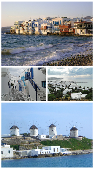
Mykonos is a Greek island, part of the Cyclades, lying between Tinos, Syros, Paros and Naxos. The island has an area of 85.5 square kilometres (33.0 sq mi) and rises to an elevation of 341 metres at its highest point. At the 2021 census, there were 10,704 inhabitants, most of whom lived in the largest town, Mykonos, which is on the west coast. The town is also known as Chora.

The Duchy of the Archipelago, also known as Duchy of Naxos or Duchy of the Aegean, was a maritime state created by Venetian interests in the Cyclades archipelago in the Aegean Sea, in the aftermath of the Fourth Crusade, centered on the islands of Naxos and Paros. It included all the Cyclades. In 1537, it became a tributary of the Ottoman Empire, and was annexed by the Ottomans in 1579; however, Christian rule survived in islands such as Sifnos and Tinos.
Tinos is a Greek island situated in the Aegean Sea. It is part of the Cyclades archipelago. The closest islands are Andros, Delos, and Mykonos. It has a land area of 194.464 square kilometres (75.083 sq mi) and a 2021 census population of 8,934 inhabitants.

Amorgos is the easternmost island of the Cyclades island group and the nearest island to the neighboring Dodecanese island group in Greece. Along with 16 neighboring islets, the largest of which is Nikouria Island, it comprises the municipality of Amorgos, which has a land area of 126.346 square kilometres and at the 2021 census had a population of 1,961.

Serifos is a Greek island municipality in the Aegean Sea, located in the western Cyclades, south of Kythnos and northwest of Sifnos. It is part of the Milos regional unit. The area is 75.207 square kilometres (29.038 sq mi) and the population was 1,241 at the 2021 census. It is located about 170 kilometres ESE of the Athenian port of Piraeus.
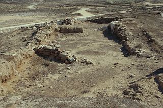
Ftelia is an archaeological site located on a beach on the island of Mykonos, Greece.

Kythnos, commonly called Thermia, is a Greek island and municipality in the Western Cyclades between Kea and Serifos. It is 56 nautical miles (104 km) from the Athenian harbor of Piraeus. The municipality Kythnos is 100.187 km2 (38.68 sq mi) in area and has a coastline of about 100 km (62 mi). Mount Kakovolo is island's highest peak (365m).

Schoinoussa or Schinoussa is an island and a former community in the Cyclades, Greece. Since the 2011 local government reform it is part of the municipality Naxos and Lesser Cyclades, of which it is a municipal unit. It lies south of the island of Naxos, in the Lesser Cyclades group, between the island communities of Irakleia and Koufonisia. The population was 229 inhabitants at the 2021 census. Its land area is 8.512 square kilometres (3.29 sq mi).

Koufonisia is a former community in the Cyclades, Greece. Since the 2011 local government reform it is part of the municipality Naxos and Lesser Cyclades, of which it is a municipal unit. The municipal unit has an area of 26.025 km2.

Psarrou is a beach and village on the island of Mykonos in Greece. The beach is located 4 km from Mykonos town and it is close to Platys Gialos. As of 2011, Psarrou had a population of 20.
Glynado (Γλυνάδο) is a community on the island of Naxos, in the Cyclades, Greece. Its population averages at 585 but increases in the summer months. Glynado's inhabitants mainly subside of farming in the fertile plain below the village, known as Leivadia, but have also ventured into hospitality services given its picturesque location sprawled out on a hill top 8 kilometres from the Island's capital Chora. It belongs to the municipality of Naxos.
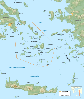
The Cyclades are Greek islands located in the southern part of the Aegean Sea. The archipelago contains some 2,200 islands, islets and rocks; just 33 islands are inhabited. For the ancients, they formed a circle around the sacred island of Delos, hence the name of the archipelago. The best-known are, from north to south and from east to west: Andros, Tinos, Mykonos, Naxos, Amorgos, Syros, Paros and Antiparos, Ios, Santorini, Anafi, Kea, Kythnos, Serifos, Sifnos, Folegandros and Sikinos, Milos and Kimolos; to these can be added the little Cyclades: Irakleia, Schoinoussa, Koufonisi, Keros and Donoussa, as well as Makronisos between Kea and Attica, Gyaros, which lies before Andros, and Polyaigos to the east of Kimolos and Thirassia, before Santorini. At times they were also called by the generic name of Archipelago.

The Church of Panagia Paraportiani is situated in the neighbourhood of Kastro, in the town of Chora, on the Greek island of Mykonos. Its name literally means "Our Lady of the Side Gate" in Greek, as its entrance was found in the side gate of the entrance to the Kastro area.
Ioulis or Ioulida, locally called Chora or Hora like the main towns of most Greek islands, and sometimes known by the island name of Kea or Keos, is the capital of the island of Kea in the Cyclades. It has a population of 633 inhabitants according to the 2011 Greek census.


