| Mátape River | |
|---|---|
 Location of mouth | |
| Location | |
| Country | Mexico |
| State | Sonora |
| Physical characteristics | |
| Mouth | |
• coordinates | 28°17′00″N110°41′00″W / 28.283333°N 110.683333°W Coordinates: 28°17′00″N110°41′00″W / 28.283333°N 110.683333°W |
| Mátape River | |
|---|---|
| Location of mouth | |
| Location | |
| Country | Mexico |
| State | Sonora |
| Physical characteristics | |
| Mouth | |
• coordinates | 28°17′00″N110°41′00″W / 28.283333°N 110.683333°W Coordinates: 28°17′00″N110°41′00″W / 28.283333°N 110.683333°W |

The Continental Divide of the Americas is the principal, and largely mountainous, hydrological divide of the Americas. The Continental Divide extends from the Bering Strait to the Strait of Magellan, and separates the watersheds that drain into the Pacific Ocean from those river systems that drain into the Atlantic Ocean and, along the northernmost reaches of the Divide, those river systems that drain into the Arctic Ocean and Hudson Bay.

The Pecos River originates in north-central New Mexico and flows into Texas, emptying into the Rio Grande. Its headwaters are on the eastern slope of the Sangre de Cristo mountain range in Mora County north of Pecos, NM, at an elevation of over 12,000 feet (3,700 m) feet. The river flows for 926 miles (1,490 km) before reaching the Rio Grande near Del Rio. Its drainage basin encompasses about 44,300 square miles (115,000 km2).

Atlas Fútbol Club is a Mexican football club. It plays home matches at the Estadio Jalisco, Guadalajara, Jalisco.
The Opata are three indigenous peoples of Mexico. Opata territory, the “Opatería” in Spanish, encompasses the mountainous northeast and central part of the state of Sonora, extending to near the border with the United States. Most Opatan towns were situated in river valleys and had an economy based on irrigated agriculture. In the 16th century, when they first met the Spanish explorers, the Opata were the most numerous people in Sonora. Today, some people continue to identify as Opatas and are working to restore aspects of pre-contact Opata culture, and revitalize Opata identity. Some sources indicate that as an identifiable ethnic group, the Opata and their language are now extinct, or nearly extinct.
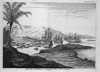
The Pánuco River, also known as the Río de Canoas, is a river in Mexico fed by several tributaries including the Moctezuma River and emptying into the Gulf of Mexico. The river is approximately 510 kilometres (320 mi) long and passes through or borders the states of Mexico, Hidalgo, Querétaro, San Luis Potosí, Tamaulipas, and Veracruz. Since one of the headwaters of the Moctezuma River is the Tula River, the Pánuco ultimately drains the Valley of Mexico containing Mexico City.

Ricardo Antonio La Volpe Guarchoni is an Argentine former professional footballer and manager. He is a World Cup-winning goalkeeper who played for most of his career in Argentina and Mexico.

The Myakka River is a river in southwestern Florida. It arises near the Hardee-Manatee county line and flows southwest and then southeast through Manatee, Sarasota and Charlotte counties to Charlotte Harbor, an arm of the Gulf of Mexico. The river is 72 miles (116 km) long and has a drainage basin of 314.7 square miles (815 km2). The last 20 miles (32 km) of the river is tidal and brackish.
The Atoyac River is a river in Oaxaca, Mexico. The Atoyac flows into the Rio Verde which empties into the Pacific near Laguna Chacahua, in Lagunas de Chacahua National Park, 90 km west of Puerto Escondido. The mountainous terrain of the region it occupies allows for no navigable rivers; instead, there are a large number of smaller ones, which often change name from area to area. The continental divide passes through the state, meaning that there is drainage towards both the Gulf of Mexico and the Pacific Ocean. Most of the drainage towards the Gulf is represented by the Papaloapan and Coatzacoalcos Rivers and their tributaries such as the Grande and Salado Rivers. Three rivers account for most of the water headed for the Pacific: the Mixteco River, Tehuantepec River, and the Atoyac, with their tributaries.
The Bolaños River is a river in Mexico flowing through the Sierra Madre Occidental, and a tributary of Rio Grande de Santiago. It has a length of 360 km and a watershed of about 10 000 square kilometers.

The SabinasRiver is a river of Mexico. It is a tributary of the Rio Salado, which in turn flows into the Rio Grande.
Río Verde,, is a river of San Luis Potosí state in eastern Mexico.
The Moctezuma River is a river in Mexico that drains the eastern side of the Trans-Mexican Volcanic Belt. It is a tributary of the Pánuco River and flows through the Mexican states of Hidalgo, Querétaro, and San Luis Potosí.
The Lacantún River is a river of Mexico.

The Sierra Aguilada is a mountain range in southwest Catron County, New Mexico on the eastern perimeter of Arizona's White Mountains. The Mogollon Mountains of New Mexico lie just east, with a south-flowing section of the San Francisco River separating them. The river then turns west, forming the southern border of the Sierra Aguilada, and continues to eventually intercept the Gila River after traversing northwest of the Big Lue Mountains of Arizona.
Black Creek of Arizona is a 55-mi (89 km) long north tributary of the Puerco River, in northeast Arizona and northwest New Mexico.

Jürgen Damm Rascón is a Mexican professional footballer who plays as a winger for Major League Soccer club Atlanta United.
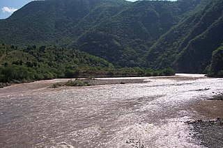
The desert chub is a cyprinid fish endemic to Mexico. It inhabits the headwaters of the Sonora and Matape rivers of northwestern México.
| | This article related to a river in Mexico is a stub. You can help Wikipedia by expanding it. |