Related Research Articles

The Jingpo (Jinghpaw) people are an ethnic group who are the largest subgroup of the Kachin peoples. The greater name for all the Kachin peoples in their own Jingpo language is the Jinghpaw. Other endonyms include Zaiwa, Lechi, Lisu, Maru, Hkahku,
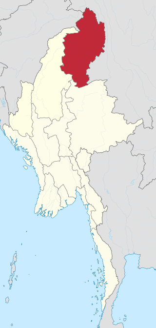
Kachin State is the northernmost state of Myanmar. It is bordered by China to the north and east ; Shan State to the south; and Sagaing Region and India to the west. It lies between north latitude 23° 27' and 28° 25' longitude 96° 0' and 98° 44'. The area of Kachin State is 89,041 km2 (34,379 sq mi). The capital of the state is Myitkyina. Other important towns include Bhamo, Mohnyin and Putao.

Shan State is a state of Myanmar. Shan State borders China (Yunnan) to the north, Laos to the east, and Thailand to the south, and five administrative divisions of Burma (Myanmar) in the west. The largest of the 14 administrative divisions by land area, Shan State covers 155,800 km2, almost a quarter of the total area of Myanmar. The state gets its name from Burmese name for the Tai peoples: "Shan people". The Tai (Shan) constitute the majority among several ethnic groups that inhabit the area. Shanland is largely rural, with only three cities of significant size: Lashio, Kengtung, and the capital, Taunggyi. Taunggyi is 150.7 km northeast of the nation's capital Naypyitaw.

Putao is the northernmost town of Kachin State, Myanmar. It is the principal town in Putao Township. It can only be reached by road during summer and winter as long as it doesn't rain in winter although the road area is tropical and rainfall also very common whole year, but is accessible year round by air if there are sufficient tourist groups to justify a plane. The area around Putao is famous for the variety of endemic birds and rare orchids, which grow naturally. Many orchid lovers are especially attracted by the so-called "Black Orchid" that can be found in the mountains east and west of Putao. Hkakabo Razi and other snow-capped mountains are visible from Putao. Putao also attracts enthusiasts, hiking to Hkakabo Razi base camp, located close to Tahaundam.
The Kachin peoples, more precisely the Kachin Wunpong or simply Wunpong, are a confederation of ethnic groups who inhabit the Kachin Hills in Northern Myanmar's Kachin State and neighbouring Yunnan Province, China, as well as Arunachal Pradesh, Assam in Northeastern India. About 1.5 million Kachin peoples live in the region. The term Kachin people is often used interchangeably with the main subset, called the Jingpo people in China.

The Kachin Independence Army is a non-state armed group and the military wing of the Kachin Independence Organisation (KIO), a political group of ethnic Kachins in Northern Myanmar. The Kachins are a coalition of six tribes whose homeland encompasses territory in China's Yunnan, Northeast India and Kachin State in Myanmar.

The Kachin Independence Organisation is a Kachin political organisation in Myanmar (Burma), established on 5 February 1961. It has an armed wing, the Kachin Independence Army, which operates in Kachin and Shan State.

The Northern Triangle temperate forests is a temperate broadleaf and mixed forest ecoregion of thick forest covering the mountains of northern Myanmar.

Hpakant is a town in Hpakant Township, Kachin State of the northernmost part of Myanmar (Burma). It is located on the Uyu River 350 km north of Mandalay. It is famous for its jade mines which produce the world's best quality jadeite.

Lweje is a town in Kachin State in northeastern Burma, opposite Zhangfeng, in Longchuan County, Yunnan Province, China. It is one of five official border trade posts with China.
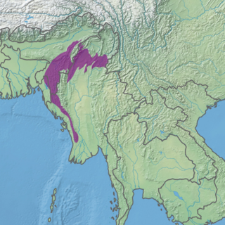
The Mizoram–Manipur–Kachin rain forests is a subtropical moist broadleaf forest ecoregion which occupies the lower hillsides of the mountainous border region joining India, Bangladesh, and Burma (Myanmar) and China's Yunnan Province. The ecoregion covers an area of 135,600 square kilometres (52,400 sq mi). Located where the biotas of the Indian Subcontinent and Indochina meet, and in the transition between subtropical and tropical regions of Asia, the Mizoram–Manipur–Kachin rain forests are home to great biodiversity. The WWF rates the ecoregion as "Globally Outstanding" in biological distinctiveness.

The N'Mai River or N'Mai Hka is a river in northern Myanmar (Burma).
The 2010–2012 Myanmar border clashes were a series of skirmishes between the Tatmadaw on one side, and the DKBA-5 and the Karen National Liberation Army (KNLA) on the other. The clashes erupted along the border with Thailand shortly after Myanmar's general election on 7 November 2010. An estimated 10,000 refugees have fled into nearby neighbouring Thailand to escape the violent conflict. There was concern that due to discontent with the elections, and speculations of electoral fraud, that the conflict could escalate into a civil war.

The Kachin conflict or the Kachin War is one of the multiple conflicts which are collectively referred to as the internal conflict in Myanmar. Kachin insurgents have been fighting against the Tatmadaw since 1961, with only one major ceasefire being brokered between them, which lasted from 1994 to 2011, a total of 17 years.

The China–Myanmar border is the international border between the territory of the People's Republic of China and Myanmar. The border is 2,129 km (1,323 mi) in length and run from the tripoint with India in the north to the tripoint with Laos in the south.
The New Democratic Army – Kachin was an armed insurgent group that operated from 1989 until its conversion into a "border guard force" in November 2009.

The Myitkyina Manau is a Manaw which takes place semi-annually in Myitkyina, Kachin State, Myanmar, and is one of the largest Manau in the world. It is an event of importance for the Kachin community of Myitkyina and is currently held at the Kachin National Manau park, Shatapru, which has permanent shadung pillars installed in the centre.

The Northern Triangle subtropical forests ecoregion covers remote, mountainous terrain in the far north of Myanmar. Due to the regions isolation it is relatively untouched and unexplored by humans. Over 95% of the ecoregion is covered with closed evergreen forest, and importantly for conservation, these forests exist in large contiguous blocks. As of the late 1990s, 140 mammal species were known to be in the region, and new species, such the Leaf muntjac discovered in 1997, are still being found.
On the night of 23 October 2022, the Myanmar Air Force launched a series of airstrikes in Hpakant Township, Kachin State, Northern Myanmar. The targeted area was within the territory of the Kachin Independence Organization's 9th Brigade in the Anangpa (အနန့်ပါ) area. The airstrikes hit an outdoor concert killing at least 80 civilians, including KIO officials and musical performers.
On October 9, 2023, the Myanmar military launched an artillery attack targeting an IDP camp near Laiza, a town in northern Myanmar that serves as the capital of the Kachin Independence Army. In the massacre, over 29 civilians were killed and 57 were injured. The incident occurred before the anniversary of the Myanmar Air Force's airstrike in Hpakant that killed at least 80 civilians killed and other KIO officials and soldiers on 23 October 2022.
References
- ↑ Leach, E. R. (1954). Political Systems of Highland Burma: A Study of Kachin Social Structure (Jan 7, 2021 ed.). Chapter 4: Routledge. ISBN 9781000324617 . Retrieved 27 October 2023.
{{cite book}}: CS1 maint: location (link) - ↑ "Students Graduate From KIO Highschools". Kachin News Group (KNG). 9 June 2022. Retrieved 27 October 2023.
- ↑ "Northern Triangle Temperate Forests". One Earth. Retrieved 27 October 2023.