
The Dwight D. Eisenhower National System of Interstate and Defense Highways, commonly known as the Interstate Highway System, is a network of controlled-access highways that forms part of the National Highway System in the United States. The system extends throughout the contiguous United States and has routes in Hawaii, Alaska, and Puerto Rico.

Shelby County is a county located in the far eastern portion of the U.S. state of Texas. As of the 2020 census, its population was 24,022. Its county seat is Center. The county was created in 1835 as a municipality of Mexico and organized as a county in 1837. It is named for Isaac Shelby, a soldier in the American Revolution who became the first governor of Kentucky.

Polk County is a county located in the U.S. state of Texas. As of the 2020 census, its population was 50,123. Its county seat is Livingston. The county is named after James K. Polk.

Nacogdoches County is a county located in the U.S. state of Texas. As of the 2010 census, its population was 64,653. Its county seat is Nacogdoches.
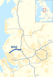
The M58 is a motorway passing through Merseyside and Lancashire, terminating in Greater Manchester. It is 12 miles (19.3 km) long and provides a link between the M6 motorway and the Metropolitan Borough of Sefton and hence on, via the A5036, to the Mersey docks in Liverpool and Birkenhead.
National highway or National Highway may refer to:
A routenumber, designation or abbreviation is an identifying numeric designation assigned by a highway authority to a particular stretch of roadway to distinguish it from other routes and, in many cases, also to indicate its classification, general geographical location and/or orientation. The numbers chosen may be used solely for internal administrative purposes; however, in most cases they are also displayed on roadside signage and indicated on maps.

Federal Highways, are a series of highways that connect with roads from foreign countries; link two or more states of the Federation; and are wholly or mostly built by the Federation with federal funds or through federal grants by individuals, states, or municipalities. Locally known as federal highway corridors, built and maintained by the federal government of Mexico via the Secretariat of Communications and Transportation. Federal Highways in Mexico can be classified into high-speed roads with restricted access and low-speed roads with non-restricted access; not all corridors are completely improved.

In the field of road transport, an interchange or a grade-separated junction is a road junction that uses grade separations to allow for the movement of traffic between two or more roadways or highways, using a system of interconnecting roadways to permit traffic on at least one of the routes to pass through the junction without interruption from crossing traffic streams. It differs from a standard intersection, where roads cross at grade. Interchanges are almost always used when at least one road is a controlled-access highway or a limited-access divided highway (expressway), though they are sometimes used at junctions between surface streets.

The National Highway System (NHS) is a network of strategic highways within the United States, including the Interstate Highway System and other roads serving major airports, ports, military bases, rail or truck terminals, railway stations, pipeline terminals and other strategic transport facilities. Altogether, it constitutes the largest highway system in the world.
Provincial Trunk Highway 59 is a major provincial highway in the Canadian province of Manitoba. It runs from the Lancaster-Tolstoi Border Crossing, through the city of Winnipeg, north to 8th Avenue in Victoria Beach on Lake Winnipeg.
National road or National route may refer to:
The United States Border Patrol operates 71 traffic checkpoints, including 33 permanent traffic checkpoints, near the Mexico–United States border. The stated primary purpose of these inspection stations is to deter illegal immigration and smuggling activities. After the September 11 attacks in 2001, they took on the additional role of terrorism deterrence. These checkpoints are located between 25 and 75 miles of the Mexico–United States border along major U.S. highways; near the southern border of the contiguous United States. Their situation at interior locations allow them to deter illegal activities that may have bypassed official border crossings along the frontier. The checkpoints are divided among nine Border Patrol sectors. There are a number of these checkpoints near the northern border of the contiguous U.S. as well, within 100 miles (160 km) of the Canada–U.S. border.
This page is based on this
Wikipedia article Text is available under the
CC BY-SA 4.0 license; additional terms may apply.
Images, videos and audio are available under their respective licenses.