Related Research Articles
Stjernøya is an island in western Finnmark county, Norway. The 248.1-square-kilometre (95.8 sq mi) island sits at the mouth of the Altafjorden on the south side of the Sørøysundet strait. It is divided among the municipalities of Loppa, Hasvik, and Alta. The highest point on the island is the 960-metre (3,150 ft) tall mountain Kjerringfjordfjellet. One of the larger fjords on the island is the Sørfjorden. There were 80 residents on the mountainous island in 2012. The main population area is at the village of Store Kvalfjord on the northeastern side of the island. On the southern part of the island there is a large nepheline syenite mine at Lillebukt. The island is separated from the mainland by the strait of Stjernsundet.
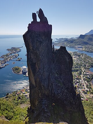
Svolværgeita or Geita is a 150-metre (490 ft) tall pinnacle at the southwest face of the mountain Fløyfjellet on the island of Austvågøya in the Lofoten archipelago. The 569-metre (1,867 ft) high Fløyfjellet is located on the edge of the town of Svolvær in Vågan Municipality in Nordland county, Norway. The first recorded time a climber reached the summit of Svolværgeita was on 1 August 1910 by Ferdinand Schjelderup, Alf Bonnevie Bryn, and Carl Wilhelm Rubenson.
Erling Welle-Strand was a Norwegian writer and resistance member.

Norwegian Automobile Federation is a Norwegian association of car owners, established in 1924, and member of Fédération Internationale de l'Automobile. The federation has 73 local chapters and more than 500,000 members. NAF is running a number of test stations, skidpans and camping sites. Among its publications is the monthly magazine Motor and the triannual NAF Veibok.
Erling Storrusten was a Norwegian business executive.
Nordgulen is a fjord in Bremanger Municipality in Vestland county, Norway. It is a branch off the main Gulen fjord. The length of the fjord is about 9 kilometres (5.6 mi). The river Svelgen is one of the primary inflows into the Nordgulen fjord. The village of Svelgen is located at the end of the Nordgulen fjord. There are settlements all around the fjord, and roads along the coast around the entire fjord.
Frøysjøen is a fjord in Bremanger Municipality in Vestland county, Norway. The fjord is about 25 kilometres (16 mi) long and between 2 and 4 kilometres wide. The fjord runs on a northeast–southwest axis between the mainland of Norway and the islands of Bremangerlandet and Frøya.

Fløya or Fløyfjellet is a mountain adjacent to the town of Svolvær in Vågan Municipality in Nordland county, Norway. The 590-metre (1,940 ft) tall mountain is located near the southeastern shore of the island of Austvågøya in the Lofoten archipelago.

Frafjord is a village and farming community in the municipality of Gjesdal in Rogaland county, Norway. It is located in the Frafjorddalen valley, at the innermost end of the Frafjorden, a branch of the larger Høgsfjorden. The village had about 100 inhabitants in 2001. The 3.8-kilometre (2.4 mi) long Frafjord Tunnel connects the village of Frafjord to the villages of Gilja and Dirdal on the other side of the mountains, replacing the old, narrow, winding road over the mountain pass. The Månafossen waterfall lies about 5 kilometres (3.1 mi) northeast of the village of Frafjord.
Sandeidfjorden is a fjord in Vindafjord municipality in Rogaland county, Norway. The 9-kilometre (5.6 mi) long fjord is a northern branch of main Vindafjorden. The village of Sandeid lies at the northern end of the fjord and the village of Vikedal lies on the eastern shore near the mouth of the fjord.

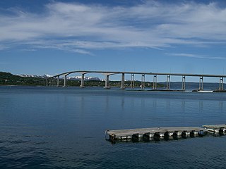
Erfjorden is a fjord in the municipalities Suldal and Hjelmeland in Rogaland county, Norway. The 16-kilometre (9.9 mi) long fjord begins at the small village of Tysse in Suldal and heads south past the village of Hålandsosen before making a sharp turn to the west before emptying into the larger Nedstrandsfjorden. The Erfjord Bridge crosses the fjord, just north of Hålandsosen. The innermost part of the fjord is sometimes referred to as the Tyssefjorden.

Erfjord Bridge is a suspension bridge in the municipality of Suldal in Rogaland county, Norway. The bridge was completed in November 1963 and it crosses the Erfjorden as part of the Norwegian National Road 13, a main road between the cities of Bergen and Stavanger in Western Norway.
Lopphavet is a stretch of open sea along the border of Troms and Finnmark counties in Norway. It has a width of about 70 kilometres (43 mi), and it stretches between the large island of Sørøya in Finnmark and the islands of Arnøya and Nord-Fugløya in Troms. The Sørøysundet strait and the Altafjorden connect to the Lopphavet on the east side of the sea. The Kvænangen fjord connects to the south. The Fugløysundet strait connects to it in the west.
Kongsfjord is a fishing settlement in the municipality of Berlevåg in Finnmark, Norway. It is one out of two preserved "væreier" localities in Finnmark.

Mefjorden is a fjord in Senja Municipality in Troms county, Norway. The 16-kilometre (9.9 mi) long fjord cuts into the large island of Senja from northwest. The villages of Mefjordvær and Senjahopen are located at the southern side of the fjord, and at the innermost point in the fjord is the village of Mefjordbotn.
Gisundet is a strait in Senja Municipality in Troms county, Norway. The 35-kilometre (22 mi) long strait separates the island of Senja from the mainland. The strait flows into the Malangen fjord in the north and into the Finnfjorden in the south. The strait is crossed by the Gisund Bridge which connects the village of Silsand on the island to the town of Finnsnes on the mainland.

Salangen (Norwegian) or Siellakvuotna (Northern Sami) is a fjord in Salangen Municipality in Troms county, Norway. The 18-kilometre (11 mi) fjord flows to the northeast from the Astafjorden and then turns to the southeast until it reaches the village of Sjøvegan at the head of the fjord. The innermost part of the fjord is also named the Sagfjorden.

Topdalsfjorden or Tofdalsfjorden is a fjord in the municipality of Kristiansand in Agder county, Norway. The 12-kilometre (7.5 mi) long fjord runs from the village of Ålefjær south to the city centre of Kristiansand. The river Topdalselva empties into the fjord at the eastern side just south of the Kristiansand Airport, Kjevik. The European route E18 highway crosses the fjord on the Varodd Bridge.
Nærøysundet is a strait in the municipalities of Nærøysund in Trøndelag county, Norway. The village of Rørvik, is located along the Nærøysundet, on the northwestern side. The 20-kilometre (12 mi) strait is crossed by the Nærøysund Bridge which connects the mainland and the island of Inner-Vikna. The shipping lane along the Norwegian coast passes through the strait, and the ship traffic is guided by the Nærøysund Lighthouse.

Heilhornet is a mountain in the municipality of Bindal in Nordland, Norway. It has a height of 1,058 metres (3,471 ft) and is a landmark visible from the sea lane. The Norwegian County Road 17 runs along the western base of the mountain.
References
- ↑ Godal, Anne Marit (ed.). "Norges Automobil-Forbund". Store norske leksikon (in Norwegian). Oslo: Norsk nettleksikon. Retrieved 25 September 2012.
- ↑ "NAF Veibok" (in Norwegian). Norwegian Automobile Federation. Archived from the original on 24 September 2012. Retrieved 25 September 2012.
- ↑ Evensen, Knut Harald, ed. (2010). NAF Veibok 2010–2012 (in Norwegian) (29 ed.). Norwegian Automobile Association.
| | This article about a book on transport is a stub. You can help Wikipedia by expanding it. |
| | This Norwegian road or road transport-related article is a stub. You can help Wikipedia by expanding it. |