
Fiji is a group of volcanic islands in the South Pacific, lying about 4,450 kilometres (2,765 mi) southwest of Honolulu and 1,770 km (1,100 mi) north of New Zealand. Of the 332 islands and 522 smaller islets making up the archipelago, about 106 are permanently inhabited. Viti Levu, the largest island, covers about 57% of the nation's land area, hosts the two official cities and most other major towns, such as Nausori, Vaileka, Ba, Tavua, Kororvou, Nasinu, and Nadi, and contains some 69% of the population. Vanua Levu, 64 km (40 mi) to the north of Viti Levu, covers just over 30% of the land area though is home to only some 15% of the population. Its main towns are Labasa and Savusavu. In the northeast it features Natewa Bay, carving out the Loa peninsula.

Espiritu Santo is the largest island in the nation of Vanuatu, with an area of 3,955.5 km2 (1,527.2 sq mi) and a population of around 40,000 according to the 2009 census.
Fijians are a nation and ethnic group native to Fiji, who speak Fijian and share a common history and culture.

Vanua Levu, formerly known as Sandalwood Island, is the second largest island of Fiji. Located 64 kilometres to the north of the larger Viti Levu, the island has an area of 5,587.1 square kilometres (2,157.2 sq mi) and a population of 135,961 as of 2007.

Skopelos is a Greek island in the western Aegean Sea. Skopelos is one of several islands which comprise the Northern Sporades island group, which lies east of the Pelion peninsula on the mainland and north of the island of Euboea. It is part of the Thessaly region. Skopelos is also the name of the main port and the municipal center of the island. The other communities of the island are Glossa and Neo Klima (Elios). The geography of Skopelos includes two mountains over 500 m (1,640 ft); Delphi (681 m/2,234 ft) in the center of the island, and Palouki (546 m/1,791 ft) in the southeast. With an area of 96 square kilometres (37 sq mi) Skopelos is slightly larger than Mykonos (85 km2/33 sq mi) and Santorini (73 km2/28 sq mi). The nearest inhabited islands are Skiathos to the west and Alonissos to the east.
Kadavu, with an area of 411 square kilometres (159 sq mi), is the fourth largest island in Fiji, and the largest island in the Kadavu Group, a volcanic archipelago consisting of Kadavu, Ono, Galoa and a number of smaller islands in the Great Astrolabe Reef. Its main administrative centre is Vunisea, which has an airport, a high school, a hospital, and a government station, on the Namalata Isthmus where the island is almost cut in two. Suva, Fiji's capital, lies 88 kilometres to the north of Kadavu. The population of the island province was 10,167 at the most recent census in 2007.

Pentecost Island is one of the 83 islands that make up the South Pacific nation of Vanuatu.

Taveuni is the third-largest island in Fiji, after Viti Levu and Vanua Levu, with a total land area of 434 square kilometres. The cigar-shaped island, a massive shield volcano which rises from the floor of the Pacific Ocean, is situated 6.5 kilometres to the east of Vanua Levu, across the Somosomo Strait. It belongs to the Vanua Levu Group of islands and is part of Fiji's Cakaudrove Province within the Northern Division.

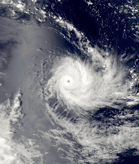
Severe Tropical Cyclone Zoe was the second-most intense tropical cyclone on record within the Southern Hemisphere. The system was first noted on December 23, 2002 as a tropical depression that had developed, within the South Pacific Convergence Zone to the east of Tuvalu. Over the next couple of days the system moved south-westwards and crossed the International Dateline early on December 25. After this the system became better organized and was declared to be a tropical cyclone and named Zoe later that day. Zoe subsequently rapidly intensified in very favorable conditions as it continued to move west-southwest towards the Solomon Islands. The system subsequently became a Category 5 tropical cyclone on both the Australian tropical cyclone intensity scale and the Saffir-Simpson hurricane wind scale on December 27. The system subsequently affected the Solomon Islands Temotu Province during that day, before it peaked with 10-minute sustained wind speeds of 240 km/h (150 mph). As the system peaked, it performed a small clockwise cyclonic loop within the vicinity of Tikopia island, as a result of the steering flow over the cyclone becoming weak and variable. The system subsequently started to move towards the southeast during December 29, in response to a strengthening steering flow, provided by an upper level trough of low pressure and a baroclinic system near New Caledonia. Over the next few days the system weakened and degenerated into a tropical depression during January 1, 2003. The system was subsequently last noted during January 4, while it was located to the southeast of New Caledonia.
Tavewa is an island of the Yasawa Islands, measuring approximately 3 kilometres long by 1 km wide. It is part of the Nacula District that lies north-west of the Fijian island of Viti Levu.

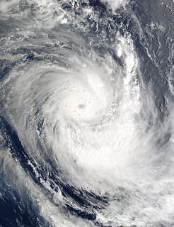
Severe Tropical Cyclone Tomas was the most intense tropical cyclone to strike Fiji since Cyclone Bebe in 1972. Forming out of a tropical disturbance on March 9, 2010, designated 14F by the Fiji Meteorological Service, the system gradually organized within an environment favoring intensification. By March 11, the disturbance had strengthened sufficiently to be classified as Tropical Cyclone Tomas, the eighth named storm of the 2009-10 South Pacific cyclone season. Modest intensification took place over the following few days, with the system attaining severe tropical cyclone status on March 13. On March 14, Tomas began to impact parts of Fiji while continuing to gain strength. As it passed near Vanua Levu on March 15, the cyclone attained its peak intensity with winds of 175 km/h (110 mph) and a pressure of 930 hPa (mbar) according to the FMS. At the same time, the Joint Typhoon Warning Center assessed it as a Category 4 equivalent storm with 1-minute sustained winds of 215 km/h (135 mph).
Severe Tropical Cyclone Ami was one of the worst cyclones to affect Fiji. The system was the third cyclone and the second severe tropical cyclone of the 2002–03 South Pacific cyclone season. Cyclone Ami developed from a low-pressure area east of Tuvalu on January 12. Originally, the storm moved slowly towards the southwest early in its existence. Influenced by an upper-level trough, Ami slowed down and began moving towards the south and then southeast. The cyclone attained severe tropical cyclone intensity on January 13. Ami made its first landfall at Vanua Levu, before subsequently making another landfall on Taveuni. Still intensifying, Ami reached peak intensity as an equivalent Category 3 cyclone on the Australian and Fiji cyclone scales on January 14. Accelerating to the southeast, the cyclone began to cross over cool sea surface temperatures and encountered wind shear. Ami transitioned into an extratropical cyclone the day after.
Severe Tropical Cyclone Joni was a damaging tropical cyclone that impacted the island nations of Tuvalu and Fiji. It was first noted within the South Pacific Convergence Zone at the start of December 1992, as a shallow tropical depression in the vicinity of the island nation Tuvalu. Over the next few days the system gradually developed further as it affected Tuvalu, before it was declared to be a tropical cyclone and named Joni by the Fiji Meteorological Service (FMS) during December 7. Over the next couple of days the system intensified further as it was steered south-westwards and posed a threat towards the Fijian dependency of Rotuma and the French territory of Wallis and Futuna. The system subsequently peaked as a Category 4 severe tropical cyclone on the Australian tropical cyclone intensity scale as it approached the Fijian Islands during December 10. Over the next couple of days the system moved through the Fijian Islands, before it became an extratropical cyclone during December 13. The system was last noted during the next day as it was absorbed by a mid-latitude trough of low pressure to the east of New Zealand.

Severe Tropical Cyclone Kina was a significant tropical cyclone which became the second-costliest storm to ever hit Fiji, only after Cyclone Winston of 2016. Total losses from Kina are estimated to be near $F170 million ($US110 million). The system was first noted as a tropical depression, to the east of the Solomon Islands on December 23. Over the next few days the system moved south-eastwards and gradually developed further, before it was named Kina, after it had developed into a tropical cyclone during December 26.

Severe Tropical Cyclone Pam was the second most intense tropical cyclone of the south Pacific Ocean in terms of sustained winds and is regarded as one of the worst natural disasters in the history of Vanuatu. A total of 15–16 people lost their lives either directly or indirectly as a result of Pam with many others injured. The storm's impacts were also felt, albeit to a lesser extent, to other islands in the South Pacific, most notably the Solomon Islands, Tuvalu, and New Zealand. Pam is the third most intense storm of the South Pacific Ocean according to pressure, after Winston of 2016 and Zoe of 2002. In addition, Pam is tied with Orson, Monica and Fantala for having the second strongest ten-minute maximum sustained winds of any cyclone in the Southern Hemisphere. Thousands of homes, schools and buildings were damaged or destroyed, with an estimated 3,300 people displaced as a result.

Severe Tropical Cyclone Sina was the only named tropical cyclone to develop within the South Pacific basin during the 1990–91 season. The system was first noted as a shallow depression within the South Pacific Convergence Zone to the west of Wallis Island. Over the next three days the system moved towards the west-northwest, before it was named Sina during November 24, after it had developed into a tropical cyclone. Over the next couple of days the system intensified further and developed an eye feature as it erratically moved towards Fiji. Sina subsequently peaked in intensity during November 26, before the system passed through the Fijian Islands over the next two days as it started to gradually weaken. Sina subsequently passed just to the north of Tongatapu in Tonga during November 29, before it passed about 160 km (100 mi) to the south of Niue and near the Southern Cook Islands during the next day. The system subsequently rapidly weakened and became an extratropical cyclone during December 1, before they were absorbed by an advancing trough of low pressure near 50°S on December 4.
Fijian food has traditionally been very healthy. Fijians prefer a more tuber and coconut based diet. High caloric foods are good for hard-working villagers who need extra calories while working on their farms but this causes a range of chronic illness such as obesity. Fiji is a multicultural country and is home to people of various races. In most Fijians' homes, food of other cultures is prepared on a regular basis such as Indian curries and Chinese dishes. Fiji is also famous for its seafood.


