Related Research Articles

For lands administration purposes, New South Wales is divided into 141 counties, which are further divided into parishes. The counties were first set down in the Colony of New South Wales, which later became the Australian state of New South Wales.

Lands administrative divisions of Australia are the cadastral divisions of Australia for the purposes of identification of land to ensure security of land ownership. Most states term these divisions as counties, parishes, hundreds, and other terms. The eastern states of Queensland, New South Wales, Victoria, and Tasmania were divided into counties and parishes in the 19th century, although the Tasmanian counties were renamed land districts in the 20th century. Parts of South Australia (south-east) and Western Australia (south-west) were similarly divided into counties, and there were also five counties in a small part of the Northern Territory. However South Australia has subdivisions of hundreds instead of parishes, along with the Northern Territory, which was part of South Australia when the hundreds were proclaimed. There were also formerly hundreds in Tasmania. There have been at least 600 counties, 544 hundreds and at least 15,692 parishes in Australia, but there are none of these units for most of the sparsely inhabited central and western parts of the country.

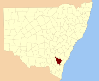
Murray County was one of the original Nineteen Counties in New South Wales and is now one of the 141 Lands administrative divisions of New South Wales. It included the area which is now part of Canberra and as far north as Lake George and Yass. It was originally bounded on the west by the Murrumbidgee River, on the east by the Shoalhaven River and on the north by the Yass River. A large area of the county was transferred to the Commonwealth government in 1909 in the Seat of Government Acceptance Act to make part of the Australian Capital Territory, along with land in Cowley County. Since then, the ACT border is now part of the western boundary. Part of the ACT border is determined by property boundaries in the Parish of Keewong, in the County of Murray; specifically the southern end of portions 177, 218, 211, 36, and 38. This is mentioned in the Seat of Government Acceptance Act of 1909.

Yancowinna County is one of the 141 cadastral divisions of New South Wales.

Irrara County is one of the 141 cadastral divisions of New South Wales. It is located south of the border with Queensland, east of the Paroo River, and west of the Warrego River.

Tongowoko County is one of the 141 cadastral divisions of New South Wales. It is located in the remote north-west of the state, south of the Queensland border.
Mingelo is a civil parish of Narromine County in central New South Wales located at the confluence of the Ten Mile Creek and the Bogan River.

Indi, New South Wales, located at 29°48'45.0"S 143°24'00.0"E is a Parish of Ularara County in north west New South Wales. It is between Milparinka, New South Wales and Wilcannia.

Mount King, New South Wales is a civil parish of Poole County in far North West New South Wales, located at.

Pinaroo is a remote civil parish of Poole County in far north west New South Wales, located at 29°08′04″S 141°06′55″E.

The Parish of Yarraba is a remote civil parish of Poole County in far North West New South Wales,.
Albert Parish located at 32°00'54.0"S 141°08'29.0"E is a remote rural locality, and cadastral Parish of Yancowinna County, far western New South Wales. The parish is on the Barrier Highway midway between Broken Hill, New South Wales and Cockburn on the South Australian border.
Neible Parish, New South Wales is a civil parish of Napier County, a county located in central western New South Wales.

Binnaway Parish is a civil Parish of Napier County, New South Wales, located on the Castlereagh River in central western New South Wales.

Mendooran Parish, New South Wales is a civil parish of Napier County, New South Wales.

Thackaringa is a rural locality, civil parish, railway stop and cattle station in Far Western New South Wales.

Naradin is a rural locality in Far western New South Wales, Australia, and a civil parish of Yancowinna County.
Wallarunga is a rural locality and ghost town located at −32.031799316 and 141.317901611 about 10 kilometres south west of Broken Hill, New South Wales.
Purnamoota is a rural locality, cattle station and ghost town of the Unincorporated Far West and a civil parish of Yancowinna County, and is located about 23 kilometers north of Broken Hill, New South Wales, Australia.
Robe, Yancowinna County is a civil parish of Yancowinna County in Far Western New South Wales. The parish is located near Purnamoota north of Broken Hill.
References
- ↑ Map of the County of Yancowinna, Western Division N.S.W., Land District of Willyama / compiled, drawn & printed at the Department of Lands, Sydney, N.S.W.
- ↑ Purnamoota (Purnamoota Station), Yancowinna Co., New South Wales, Australia.
- ↑ David R Horton (creator), © Aboriginal Studies Press, AIATSIS, and Auslig/Sinclair, Knight, Merz, 1996.
- ↑ "History." Broken Hill: Accessible Outback. 2007, Edition 15, p4.