
Khurja is a city in Bulandshahr district in the Indian state of Uttar Pradesh. It is situated around 20 km from Bulandshahr and 85 km from Delhi. Khurja supplies a large portion of the ceramics used in the country, hence it is sometimes called The Ceramics City. The city is also famous for a special sweet, known as "khurchan".

Ballia district is one of the districts of Uttar Pradesh, India. Ballia district is a part of Azamgarh division situated in the east of Uttar Pradesh. The main economic activity is agriculture. City is the district headquarters and commercial market of this district. It is the birthplace of former prime minister of India Chandra Sekhar Singh There are six tehsils in this district: Ballia, Bansdih, Rasra, Bairia, Sikandarpur and Belthara. Rasra is the second major commercial area of the district, having a government sugar mill and a cotton weaving industry. Though Ballia's core occupation is agriculture there are some additional small industries. Maniar is known for its bindi industry and is a major supplier.

Firozabad district is one of the western districts of the Indian state of Uttar Pradesh, which has Firozabad city as its district headquarters. Administratively, the district is a part of the Agra division.

Bachhraon is a city and a municipal board in Amroha district in the state of Uttar Pradesh, India.
Behta Hajipur is a census town in the Loni block of Ghaziabad district in the Indian state of Uttar Pradesh. It is a part of the National Capital Region (NCR). At one end (southwest), the town's boundary terminates at National Highway 709B, which connects Delhi to Saharanpur, and at the other end (northeast), the boundary ends at Loni-Ghaziabad Road. It also share its territories with the neighboring census town, Mandoli.
Chitbara Gaon is a town and a nagar panchayat of Ballia district, Uttar Pradesh, India.
Jalesar is a Nagar Palika in Etah Sub District, Etah district in the Indian state of Uttar Pradesh. There is a fort of Awagarh near Jalesar, Awagarh is 15 kilometres (9.3 mi) from Jalesar It is connected by road to other towns such as Hathras, Etah, Aligarh, Firozabad and Agra.
Kandhla is a town, near Shamli City and municipal board in Shamli District in the Indian state of Uttar Pradesh.
Khudaganj is a town and a nagar panchayat in Tehsil Tilhar Shahjahanpur district in the Indian state of Uttar Pradesh.
Kopaganj is a town and a nagar panchayat in Mau district in the Indian state of Uttar Pradesh.
Kora Jahanabad is a town in Fatehpur district in the Indian state of Uttar Pradesh. It is located on Kora Road, about 6 km east of Jahanabad, about 43 km south of Kanpur, about 78 km west by northwest of Fatehpur, and 480 km southeast of Delhi. Local people also call it "Jahanabad".
Kukshi is a town in Dhar district of Madhya Pradesh state, India. Kukshi has population of around 37,482 making it a Tier-3 city and a Semi-Urban centre. It is a Nagar Parishad. Kukshi is famous for the business of cotton, mirchi, gold and silver, and ready made garments.
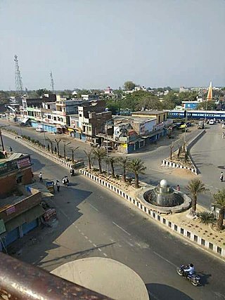
Rasra is a city and a municipal board in Ballia district in the Indian state of Uttar Pradesh. It is one among six tehsils that come under Ballia district, Rasra is also known as 'Chhoti Kashi' and 'Nath Nagri' due to the presence of Nath Baba mandir which is a well known religious spot. In past the production of sugar from rotten sugarcanes lead to the city being named 'Rasra' which is a portmanteau word made-up of two hindi words 'Ras' (रस) meaning juice and 'Sada/Sara' (सड़ा) meaning rotten. It has an important market for the nearby villages. Lounglatta is the famous sweet of Rasra. Dussehra is one of two very prominent festivals, here, alongside Chhath. Rasra has top schools of district. Rasra has second largest Durga Puja celebration in Uttar Pradesh after Ram Nagar, Varanasi. Rasra has a busy fish market, chicken market and mutton narket. It has also Sadar Bazaar, Station Road Market, Hospital Complex Market, Mission Road Market, Kali Maa ka chauraha. This place is known for all religious cultures, and has many temples, churches and mosques.
Reoti is a town and a nagar panchayat in Ballia district in the Indian state of Uttar Pradesh. Known for got freedom before 1947 As usual India had got freedom on 15 Aug 1947 but all across the India Reoti town got freedom in 1942.
Yusufpur Mohammadabad is a town and a Township in Ghazipur district in the Indian state of Uttar Pradesh. Haydaria village near Mohammadabad is the starting point of Purvanchal Expressway.

Harchandpur is a village and corresponding community development block in Raebareli district, Uttar Pradesh, India. It is located on the Baiti river, which is a tributary of the Sai, and it is northeast from the district headquarters on the road to Lucknow. Particularly since the coming of the railway in the 1800s, Harchandpur serves as one of the main commercial centres for the surrounding region; it is also a major exporter of local goods. As of 2011, its population is 4,348 people, in 833 households.
Aryapur Khera is the village. Mainpuri city is an administrative headquarters of this village. Mainpuri is located to the north-east of Agra.

≥→≥
Belthara Road is a Nagar Panchayat city with a railway station in the north-western corner of Ballia district of Uttar Pradesh, India.
Narhi (Nagra) is a village in Rasra Tehsil in Ballia district of Uttar Pradesh, India. It belongs to Azamgarh division. It is located 42 km north from District headquarters Balliav, 4 km from Nagra, and 362 km from the state capital, Lucknow.
