
Chiapas, officially the Free and Sovereign State of Chiapas, is one of the states that make up the 32 federal entities of Mexico. It is divided into 124 municipalities as of September 2017 and its capital city is Tuxtla Gutiérrez. Other important population centers in Chiapas include Ocosingo, Tapachula, San Cristóbal de las Casas, Comitán and Arriaga. It is the southernmost state in Mexico, and it borders the states of Oaxaca to the west, Veracruz to the northwest and Tabasco to the north, and the Petén, Quiché, Huehuetenango, and San Marcos departments of Guatemala to the east and southeast. Chiapas has a coastline along the Pacific Ocean to the south.

The Lacandon are one of the Maya peoples who live in the jungles of the Mexican state of Chiapas, near the southern border with Guatemala. Their homeland, the Lacandon Jungle, lies along the Mexican side of the Usumacinta River and its tributaries. The Lacandon are one of the most isolated and culturally conservative of Mexico's native peoples. Almost extinct in 1943, today their population has grown significantly, yet remains small, at approximately 650 speakers of the Lacandon language.

Cuatro Ciénegas is a city in the northern Mexican state of Coahuila. It stands at 26°59′N102°03′W, at an average elevation of 740 metres (2,430 ft) above sea level. The city serves as the municipal seat for the surrounding municipality of the same name.

Laguna de Términos is the largest tidal lagoon by volume located entirely on the Gulf of Mexico, as well as one of the most biodiverse. Exchanging water with several rivers and lagoons, the Laguna is part of the most important hydrographic river basin in Mexico. It is important commercially, as well as ecologically by serving as a refuge for an extensive number of flora and fauna; its mangroves provide an important role as a refuge for migratory birds.

The Khasi Hills is a low mountain formation on the Shillong Plateau in Meghalaya state of India. The Khasi Hills are part of the Garo-Khasi-Jaintia range and connects with the Purvanchal Range and larger Patkai Range further east. Khasi Hills, and the whole Garo-Khasi-Jaintia range, are in the Meghalaya subtropical forests ecoregion.

San Mateo Ixtatán is a municipality in the Guatemalan department of Huehuetenango. It is situated at 2,540 metres (8,330 ft) above sea level in the Cuchumatanes mountain range and covers 560 square kilometres (220 sq mi) of terrain. It has a cold climate and is located in a cloud forest. The temperature fluctuates between 0.5 and 20 °C. The coldest months are from November to January and the warmest months are April and May. The town has a population of 15,090 and is the municipal center for an additional 28,000 people living in the surrounding mountain villages. It has a weekly market on Thursday and Sunday. The annual town festival takes place from September 19 to September 21 honoring their patron Saint Matthew. The residents of San Mateo belong to the Chuj Maya ethnic group and speak the Mayan Chuj language, not to be confused with Chuj baths, or wood fired steam rooms that are common throughout the central and western highlands.

San Sebastián Huehuetenango is a municipality in the Guatemalan department of Huehuetenango. It is located approximately 27 km. north of the city of Huehuetenango on Inter-American Highway heading toward the Mexican border at La Mesilla. The language spoken is Mayan Mam. The majority of the inhabitants are subsistence farmers.
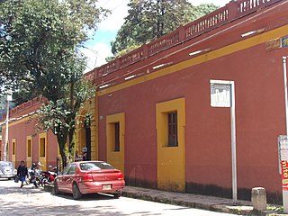
Casa Na Bolom is located in San Cristóbal de las Casas, Chiapas, Mexico. It was the home of archeologist Frans Blom and his wife, documentary photographer, journalist, environmental pioneer Gertrude Duby Blom. Today, Casa Na Bolom operates as a hotel, museum, and research center run by Asociación Cultural Na Bolom, a non-profit organization dedicated to the protection of the Lacandon Maya and the preservation of the Chiapas rain forest.

The Lacandon Jungle is an area of rainforest which stretches from Chiapas, Mexico, into Honduras and into the southern part of the Yucatán Peninsula. The heart of this rainforest is located in the Montes Azules Biosphere Reserve in Chiapas near the border with Guatemala in the Montañas del Oriente region of the state. Although most of the jungle outside the reserve has been partially or completely destroyed and damage continues inside the Reserve, the Lacandon is still the largest montane rainforest in North America and one of the last ones left large enough to support jaguars. It contains 1,500 tree species, 33% of all Mexican bird species, 25% of all Mexican animal species, 56% of all Mexican diurnal butterflies and 16% of all Mexico's fish species.

Highgate Wood is a 28 hectare area of ancient woodland in North London, lying between East Finchley, Highgate and Muswell Hill. It was originally part of the ancient Forest of Middlesex which covered much of London, Hertfordshire and Essex and was mentioned in the Domesday Book. It lies in the London Borough of Haringey, but is owned and managed by the City of London Corporation.

Marcoola is a coastal town and locality in the Sunshine Coast Region, Queensland, Australia. It includes part of the pristine Mount Coolum national park, borders with the Maroochy River and is part of the Maroochy River Catchment Area and includes urban developments of Town of Seaside and Mount Coolum Shores. The name Marcoola was a coined name and reflects its location between MARoochydore and COOLum.
Maxcanú is a large town in the western part of the Mexican state of Yucatán; it also functions as the seat for the Maxcanú Municipality. It is located on Federal Highway 180, approximately 62 km (38.5 mi) south of Mérida.
Mexican Flora and Fauna Protection Areas comprise 29 protected natural areas of Mexico administrated by the National Commission of Protected Natural Areas, an agency of the federal government.

Allium cernuum, known as nodding onion or lady's leek, is a perennial plant in the genus Allium. It grows in dry woods, rock outcroppings, and prairies. It has been reported from much of the United States, Canada and Mexico including in the Appalachian Mountains from Alabama to New York State, the Great Lakes Region, the Ohio and Tennessee River Valleys, the Ozarks of Arkansas and Missouri, and the Rocky and Cascade Mountains of the West, from Mexico to Washington. It has not been reported from California, Nevada, Florida, Louisiana, Mississippi, New Jersey, Delaware, New England, or much of the Great Plains. In Canada, it grows from Ontario to British Columbia.
Bacanora is a small town in Bacanora Municipality in the east of the Mexican state of Sonora. It is located at the geographical coordinates of 28°59′N109°24′W.
The Sierra del Lacandón is a low karstic mountain range in Guatemala and Mexico. It is situated in the north-west of the department of El Petén and the south-east of Chiapas. Its highest points are located near the Mexican border at coordinates 17.244195°N 91.202145°W and 17.195087°N 91.086102°W The range consists of southeast to northwest trending ridges of folded Cretaceous limestone and dolomite hills rising above the lowlands of the Petén Basin.
Rafael Lucio is a municipality located in the montane central zone of the State of Veracruz, about 9 km from state capital Xalapa. It has a surface of 24.68 km2. It is located at 19°35′N96°59′W. By Decree of November 5, 1932 Rafael Lucio's municipality and the head-board is created they are named Rafael Lucio, in honor of the illustrious doctor of Xalapa.

Unión Hidalgo is a town and municipality in Oaxaca in south-western Mexico. It is part of the Juchitán District in the west of the Istmo de Tehuantepec region.
Santo Domingo Tonalá is a town and municipality in Oaxaca in south-western Mexico. The municipality covers an area of km². It is part of the Huajuapan District in the north of the Mixteca Region.
Sierra de Quila, officially the Sierra de Quila Flora and Fauna Protection Area, is a Mexican Flora and Fauna Protection Area in the state of Jalisco, Mexico, managed by the National Commission of Natural Protected Areas (CONANP), and located within six municipalities: San Martín de Hidalgo, Tecolotlán, Cocula, Atengo, Tenamaxtlán, and Ameca. Having an area of 15,193 hectares and established as a wildlife protection zone on August 4, 1982, Sierra de Quila is the most recent and smaller of the two wildlife protection areas in the state, the other being La Primavera.