Nahal Telem

Last updated

Coordinates: 31°34′18″N35°1′53″E / 31.57167°N 35.03139°E / 31.57167; 35.03139

Geographic coordinate system Coordinate system

A geographic coordinate system is a coordinate system that enables every location on Earth to be specified by a set of numbers, letters or symbols. The coordinates are often chosen such that one of the numbers represents a vertical position and two or three of the numbers represent a horizontal position; alternatively, a geographic position may be expressed in a combined three-dimensional Cartesian vector. A common choice of coordinates is latitude, longitude and elevation. To specify a location on a plane requires a map projection.

Nachal Telem

ptKH m`rh klpy KHvTS.JPG

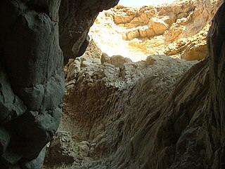
The caves of Nachal Telem
Country Palestinian territories, Israel
Physical characteristics
Main source at the village of Telem, West Bank
River mouth Nachal Guvrin, West Bank

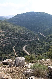
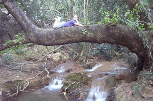
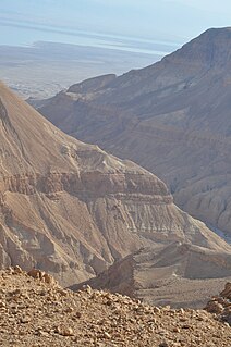
Nachal Telem (Hebrew: נחל תלם) is a wadi located in the West Bank begins in the western part of the Judaean Mountains and goes westwards. The official Israeli name of the wadi is "Nachal Natziv" (נחל נציב) but this name is not used in practice.

Wadi River valley, especially a dry (ephemeral) riverbed that contains water only during times of heavy rain

Wadi, alternatively wād, is the Arabic term traditionally referring to a valley. In some instances, it may refer to a dry (ephemeral) riverbed that contains water only when heavy rain occurs.

West Bank Part of the Palestinian territories near the Mediterranean coast of Western Asia

The West Bank is a landlocked territory near the Mediterranean coast of Western Asia, bordered by Jordan to the east and by the Green Line separating it and Israel on the south, west and north. The West Bank also contains a significant section of the western Dead Sea shore. The West Bank was the name given to the territory that was captured by Jordan in the aftermath of the 1948 Arab–Israeli War, and subsequently annexed in 1950 until 1967 when it was occupied by Israel during the 1967 Six-Day War.

Judaean Mountains Mountain range in Israel and the West Bank

The Judaean Mountains, or Judaean Hills, is a mountain range in Israel and the West Bank where Jerusalem and several other biblical cities are located. The mountains reach a height of 1,026 metres (3,366 ft). The Judean Mountains can be separated to a number of sub-regions, including the Mount Hebron ridge, the Jerusalem ridge and the Judean slopes. These mountains formed the heartland of the Kingdom of Judah, where the earliest Jewish settlements emerged.

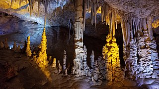
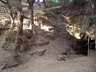
The wadi contains the El Kof Nature Reserve (שמורת יער אל קוף) and the Tor-Safa Cave (מערת טור-צפא) which is the largest of the caves in the western slopes of the Judea mountain.

The El Kof Nature Reserve was planted in 1927 during the British mandate by the Department of Government plantings, originally on an area of 1,000 dunams. In 1966 the Forestry Department of the Jordanian government expanded the forest as it extended it with additional 900 dunams. [1]

A dunam, also known as a donum or dunum and as the old, Turkish, or Ottoman stremma, was the Ottoman unit of area equivalent to the Greek stremma or English acre, representing the amount of land that could be ploughed by a team of oxen in a day. The legal definition was "forty standard paces in length and breadth", but its actual area varied considerably from place to place, from a little more than 900 m2 in Ottoman Palestine to around 2500 m2 in Iraq.

On December 28, 2007 a terrorist attack was carried out in Nahal Telem in which two Jewish tourists were killed. [2]

Related Research Articles

Mount Gilboa Mountain range in northern Israel.

Mount Gilboa, sometimes called the Mountains of Gelboe, is a mountain range overlooking the Jezreel Valley in northern Israel. The meaning of the name Gilboa is boiling springs; bubbling fountains; agitated pools; water bursting from the rock, which makes it similar to the Arabic name "Jebel Faqqua".

Nahal Sorek river in Israel

Nahal Sorek, also Soreq, is one of the largest, most important drainage basins in the Judean Hills. It is mentioned in the Book of Judges 16:4 of the Bible as the border between the ancient Philistines and the Tribe of Dan of the ancient Israelites. It is known in Arabic as Wadi es-Sarār, sometimes spelled Surar, and by various names along different segments, such as Wadi Qalunya near Motza, Wadi al-Tahuna, and Nahr Rubin further downstream.

Ein Gedi oasis in Israel

Ein Gedi, literally "spring of the kid " is an oasis and a nature reserve in Israel, located west of the Dead Sea, near Masada and the Qumran Caves. Ein Gedi was listed in 2016 as one of the most popular nature sites in the country.

Avshalom Cave cave in Israel

Avshalom Cave, also known as Soreq Cave or Stalactites Cave, is a 5,000 m2 cave on the western side of Mt. Ye'ela, in the Judean hills in Israel, unique for its dense concentration of stalactites and other cave formations.

Wadi Qelt

Wadi Qelt, also Nahal Prat, formerly Naḥal Faran, is a valley, riverine gulch or stream in the West Bank, originating near Jerusalem and running into the Jordan River near Jericho and the Dead Sea.

Sataf Village in Jerusalem, Mandatory Palestine

Sataf was a Palestinian village in the Jerusalem Subdistrict depopulated during the 1948 Arab–Israeli War. It was located 10 km west of Jerusalem, with Sorek Valley bordering to the east.

Al-Shuna Village in Safad, Mandatory Palestine

Al-Shuna was a Palestinian Arab village in the Safad Subdistrict. It was depopulated during the 1947–1948 Civil War in Mandatory Palestine on April 30, 1948, by the Palmach's First Battalion of Operation Yiftach. It was located 6 km south of Safad, overlooking the deep gorge of Wadi al-'Amud.

Ein Feshkha

Ein Feshkha is a nature reserve and archaeological site on the northwestern shore of the Dead Sea, about three kilometers south of Qumran in the West Bank. It is named for a spring of brackish water in the area. The Ein Feshkha nature reserve consists of an open reserve with pools of mineral water for bathing surrounded by high foliage and another section that is closed to visitors to protect the native flora and fauna.

Nahal Amud river in Israel

Nahal Amud, also known as the Wadi Amud, is a stream in the Upper Galilee region of Israel that flows into the Sea of Galilee.

Hurshat Tal

Hurshat Tal is a national park and nature reserve in the Northern District of Israel. In 1968, 765 dunams were declared national park lands and 107 dunams were declared a nature reserve.

Nahal Tavor wadi

Nahal Tavor, lit.Tabor Stream, is an intermittent stream in the Lower Galilee, Israel.

Nahal Kziv perennial stream in the Upper Galilee, Israel

Nahal Kziv is a 39-kilometer long perennial stream in the Upper Galilee, Israel. During the winter, rainfall fills the channel, and springs along the riverbed add to the flow. Currently, Mekorot pumps the water of the river's principal spring, Ein Ziv, and supplies it to the residents of the Western Galilee, making the channel between Ein Ziv and Ein Tamir an intermittent stream. On the southern ridge overlooking the valley sits a 12th-century Crusader castle, Montfort, the old headquarters of the Teutonic Order in the Holy Land.

Paar Cave cave in Israel

The Pa'ar Cave is a karstic sinkhole in the Upper Galilee, Israel. The cave is located between the Adir peak, and kibbutz Sasa. The sinkhole channels the water flowing from the Pa'ar stream to groundwater level.

Nahal Betzet

Nahal Betzet, Arabic: Wadi Karkara‎, is a once-perennial and now intermittent stream in the Upper Galilee, Israel. Most of it is part of the nature reserve named for the stream.

Wadi Qana

Wadi Qana is an intermittent stream in Israel and the West Bank, the northernmost tributary of the Yarkon River.

Nahal Hever

Nahal Hever is an Intermittent stream (wadi) in the Judean Desert that flows from Yatta area to the Dead Sea. The named is derived from the city of Hebron. The stream has a few waterfalls, the tallest one amounts to over 140 metres (460 ft).

Nahal Mearot Nature Reserve wadi

The Caves of Nahal Me’arot / Wadi el-Mughara, named here by the Hebrew and Arabic name of the valley where they are located, are a UNESCO Site of Human Evolution in the Carmel mountain range near Haifa in northern Israel. The four UNESCO-listed caves are the Tanur / Tabun, Gamal / el-Jamal (Camel), Nahal / el-Wad (Stream), and Gedi / Es-Skhul (Kid) Cave. The four caves were proclaimed a site of "outstanding universal value" by UNESCO in 2012. They are protected within a nature reserve.

Wadi Og

Wadi Og is a winterbourne stream near the kibbutz and Israeli settlement Almog. It runs for 30 km from Jerusalem till the Dead Sea.

National Botanic Garden of Israel Botanical garden located on Mount Scopus

National Botanic Garden of Israel Hebrew: הגן הבוטני לצמחי ארץ ישראל ע"ש מונטג'יו למפורט), not to be confused with Jerusalem Botanical Gardens, which was originally planned as its successor, is a botanical garden located on the Mount Scopus campus of the Hebrew University of Jerusalem. It covers an area of 25 dunams and contains 950 varieties of plants, 40% of them wild.

Nahal Gerar, also Nachal Grar is a wadi in Israel, in the Negev desert. The Arabic name of the wadi is Wadi esh-Sheri'a. Along this wadi, there are several important ancient Bronze Age archaeological sites. During the Early Iron Age this was an area of Philistine settlement.

References

  1. Mount Hebron: A Survey of landscape and itineraries - Menahem Markus, David Amit, page 239
  2. 2 Israeli Settlers Killed - New York Times