Related Research Articles
Namo or NaMo may refer to:

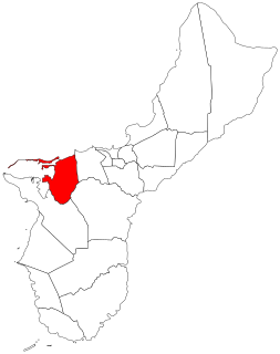
Santa Rita is a village located on the southwest coast of the United States territory of Guam with hills overlooking Apra Harbor. According to the 2000 census it has a population of 7,500, down from 11,857 in 1990. Santa Rita is the newest village in Guam, having been established after the Second World War.
Piti is a village located on the western shore of the United States territory of Guam. It contains the commercial port of Guam at Apra Harbor as well as several of the island's largest power plants. NAVFAC Marianas is located there.

Yona is a village in the United States territory of Guam.

Agana Heights is one of the nineteen villages in the United States territory of Guam. It is located in the hills south of Hagåtña, in the central part of the island. The United States Naval Hospital is located in this largely residential village.

The Legislature of Guam is the law-making body for the United States territory of Guam. The unicameral legislative branch consists of fifteen senators, each serving for a two-year term. All members of the legislature are elected at-large with the island under one whole district. After the enactment of the Guam Organic Act in 1950, the First Guam Legislature was elected composing of 21 elected members. Today, the current fifteen-member 35th Guam Legislature was elected in November 2018.

Mongmong-Toto-Maite is a municipality in the United States territory of Guam composed of three separate villages east of Hagåtña that experienced development after the Second World War.
The area code 671 is the local telephone area code of the United States territory of Guam. It was created with the beginning of permissive dialing on July 1, 1997, replacing Guam's previous International Telecommunication Union country code 671, at the end of permissive dialing on July 1, 1998.
The Namo Falls are two waterfalls, the Grandmother (Guella) and the Grandfather (Guello), in the Namo River within the Namo park area on the island of Guam. The botanical park is located on the border of the villages of Agat and Santa Rita off Route 12, in the south-west coast of the island. The Namo Falls Botanic Park is privately owned and a fee is required. The park provides a walk through a botanic garden featuring tropical flowers like mangoes, breadfruit, coconut, star apple, jackfruit, bananas, hibiscus, bougainvillea, orchids, and a large variety of gingers and heliconias, The Grandmother Falls (Guella) can be used for swimming.
The Talofofo Bay is an inlet in the south-eastern coast of the island of Guam at the mouth of the Talofofo River.
The Pago River is one of the longest rivers in the United States territory of Guam. Rising close to the west coast, it traverses the island, flowing into the sea at Pago Bay in the central east coast. The village of Yona lies just to the south of the river's mouth.
The Talofofo River is one of the longest rivers on the Pacific Ocean island of Guam. Rising on the eastern slopes of Mount Lamlam in the island's south-west, it traverses the island in a north-eastward direction, flowing into the sea at Talofofo Bay.
The Agfayan River is a river in the United States territory of Guam.
The Ajayan River is a river in the United States territory of Guam.
The Maagas River is a river in the United States territory of Guam.
The Maulap River is a river in the United States territory of Guam.
The Pajon River is a river in the United States territory of Guam.

Talofofo is a village located in the southern part of the United States territory of Guam, on the east coast. The village center is located in the hills above the coast, while the smaller coastal community below the cliff is known as Ipan.
The Episcopal Church in Micronesia is a mission within Province VIII of the Episcopal Church. It has four congregations, three on Guam and one on Saipan, in the Commonwealth of the Northern Mariana Islands, as well as St. John's Episcopal School in Upper Tumon, Guam. The 2016 parochial reports indicated two parishes and 260 members.
References
Coordinates: 13°24′03″N144°39′49″E / 13.4009°N 144.6635°E
| This article related to a river in Guam is a stub. You can help Wikipedia by expanding it. |