
Mirzapur is a city in Uttar Pradesh, India, 827 km from Delhi and 733 km from Kolkata, almost 91 km from Prayagraj and 61 km from Varanasi. It is known for its carpets and brassware industries, and the folk tradition of kajri and birha music. The city is surrounded by several hills of the Maikal range and is the headquarters of Mirzapur district.

Jaunpur is a city and a municipal board in Jaunpur district in the Indian state of Uttar Pradesh. It is located 228 km southeast of state capital Lucknow. Demographically, Jaunpur resembles the rest of the Purvanchal area in which it is located.

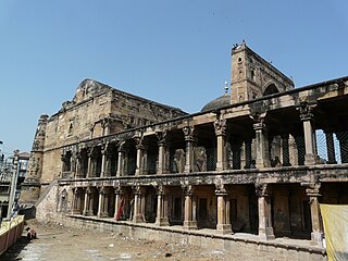
Raebareli is a city in Indian state of Uttar Pradesh. It is the administrative headquarters of Raebareli district and a part of Lucknow Division. The city is situated on the banks of the Sai river, 82 km (51 mi) southeast of Lucknow. It possesses many architectural features and sites, chief of which is a strong and spacious fort. As of 2011, Raebareli has a population of 191,316 people, in 35,197 households.

Varanasi division is an administrative geographical unit of Uttar Pradesh state of India. Varanasi is the administrative headquarters of the division. The division consists of districts of Varanasi, Chandauli, Ghazipur, and Jaunpur and is loosely equivalent to the Benares State.
Jaunpur district is a district in the Varanasi Division of the Indian state of Uttar Pradesh. The district headquarters is the city of Jaunpur which is situated on the banks of the Gomti River. It is located 228 km southeast of the state capital Lucknow. 65 km northwest of Varanasi and 732 km southeast of New Delhi. The district has two Lok Sabha seats and nine Vidhan Sabha seats. According to the 2011 census, Jaunpur has a gender ratio of 1,018 females to 1,000 males, the highest in Uttar Pradesh. The main languages spoken in the district is Hindi and Urdu.

Bhadohi District is a district of Uttar Pradesh state in northern India. The city of Gyanpur is the district headquarters. Bhadohi is one of largest centres of Carpet Industries in India and is worldwide known as 'Carpet City of India'. Carpets of Bhadohi have 'Geographical Indication' tag attached to it. Bhadohi has huge geographical significance and position attached to it due to its location between two culturally important and rich heritage cities of Prayagraj and Varanasi.

Ghazipur district is a district of Uttar Pradesh state in northern India. The city of Ghazipur is the district headquarters. The district is part of Varanasi Division. The region of Ghazipur is famous mainly for the production of its unique rose-scented Spray called Gulab Jal, and for the tomb of the Governor General of British India, Lord Cornwallis, who died here. His tomb is situated in Western part of City, and is conserved by Archaeological Survey of India.
Kerakat or Kirakat is a town and nagar panchayat in Jaunpur district of the Indian state of Uttar Pradesh with a population of approximately 13,500. It is situated near the Gomati River, which helps the land around the town stay very fertile. Kerakat or Kirakat forms a part of Varanasi Division. It is located 30 km east of the city of Jaunpur and 279 km from Lucknow, the capital of Uttar Pradesh.
Mariahu (Mariyahu) is a town and a nagar panchayat in Jaunpur district in the Indian state of Uttar Pradesh. Its name Mariahu was given by Nanwag (Nandwak) king Naun Rao in 16th century on the name of Mandav Deo, the patreon deity of the Nanwag clan. The samadhi of Mandav dev is situated near to Chutka Devi temple which is in the east of tehsil. Mostly tehsil was ruled by Nanwag Rajputs who were the local rulers during 16th and 17th century. Baghi Sangram Singh a leader of the Nanwags revolted against the British East India company during the revolt of 1857 and defeated them on several occasions. It is one of the six tehsils of Jaunpur district, with the others being Jaunpur city, Shahganj, Machalishahar, Badlapur and Keraket.

Musafirkhana is a town and tehsil in Amethi district in Indian state of Uttar Pradesh. The word "Musafirkhana" means "Sarai," or "Dharamshala". Musafirkhana is located 32 km northwest of Amethi, 20 km from Jagdishpur. Gauriganj and Amethi are accessible from Musafirkhana via roadways; the nearest railway station is the Musafirkhana railway station on the Lucknow–Varanasi rail route via Sultanpur, and the nearest airport is the Amausi airport. It is surrounded by more than 100 villages. The town is between 26.37° north latitude and 81.8° east longitude at a height of 102 metres (434 feet) above mean sea level.

Benares or Banaras State was a kingdom and later princely state in what is today Uttar Pradesh, India. On 15 October 1948, Benares' last ruler signed the accession to the Indian Union.
Katghara is a village in Ram Nagar Block of Mariahu Tehsil of Jaunpur district of Uttar Pradesh, India. Its Postal Zip Code is 222161
Janakpatti is a village in Pindra tehsil, Varanasi district, Uttar Pradesh, India. The village has population of about 450 and is located close to the Varanasi–Jaunpur border.
Pilkichha is a village in Khutahan, Jaunpur district, Varanasi division, Uttar Pradesh, India.
Meghpur is a village in Jaunpur, Uttar Pradesh, India. This village falls under Jalalpur Thana. The latitude and longitude position is 25.6037802, 82.7321342. This Village is 4 km far away from Jalalganj (JLL) Railway station and 3 km from Jalalpur. This Village is 24 km away from Lal Bahadur Shastri International Airport. The neighbor villages are Purev, Mojara, Nahora, Than, Rasulpur, Lakhamipur and Salempur.
Usraon (Mariyahu) is a town and nagar panchayat in Jaunpur district in the Indian state of Uttar Pradesh. It is one of the six tahsils of Jaunpur District; the others are Jaunpur City, Shahganj, Machalishahar, Badlapur and Kerakat.
Gaag Khurd is a village in Pindra Tehsil of Varanasi district in the Indian state of Uttar Pradesh. Only one shia Muslim Village between Varanasi and Jaunpur District. The village comes under Gangkala gram panchayat. The village is about 27 kilometers North-West of Varanasi city, 266 kilometers South-East of state capital Lucknow and 791 kilometers South-East of the national capital Delhi.

Jigni State was a princely state of the Bundelkhand Agency of the British Raj. It was a small Sanad state of about 82.87 km2 with a population of 4,297 inhabitants in 1901. The state was surrounded by the Hamirpur and Jhansi districts of the United Provinces.
Bhadon is a village and Gram Panchayat located in Martinganj tehsil of the Azamgarh District in the Indian state of Uttar Pradesh, near the border with Jaunpur District. It is 37.7 kilometres (23.4 mi) north-east of the district headquarters in Azamgarh and 229.9 kilometres (142.9 mi) from the state capital of Lucknow.

Inhauna is a village and corresponding in Singhpur block of Rae Bareli district, Uttar Pradesh, India. As of 2011, its population is 13,049, in 2,021 households. Located at the junction of the Raebareli-Rudauli and Lucknow-Jaunpur roads, Inhauna is an old town that once served as the seat of a pargana as well as (briefly) a tehsil, and it has the ruins of an old fort built under the Nawabs of Awadh. The old marketplace, known as Ratanganj, was built in 1863 by the tahsildar Ratan Narain. Markets are held twice per week, on Mondays and Thursdays, and most of the trade is in livestock.

