Southern Norway is the geographical region (landsdel) along the Skagerrak coast of southern Norway. The region is an informal description since it does not have any governmental function. It roughly corresponds to the old petty kingdom of Agder as well as the two present-day counties of Vest-Agder and Aust-Agder. The total combined area of Vest-Agder and Aust-Agder counties is 16,493 square kilometres (6,368 sq mi). The name is relatively new, having first been used in Norway around 1900.

Nidelva is the main river in the Arendal drainage basin in Aust-Agder county, Norway. The 221.7-kilometre (137.8 mi) long river begins at the confluence of two rivers: Nisserelva and Fyreselv. The confluence is located by the village of Haugsjåsund in Nissedal municipality in southern Telemark county. The river flows south into the Skagerrak at the city of Arendal. The watershed covers 4,011 square kilometres (1,549 sq mi) and has an average waterflow of 114.4 cubic metres per second (4,040 cu ft/s) at Rykene near the mouth. The highest waterflow ever recorded on the river was 1,200 cubic metres per second (42,000 cu ft/s) in the autumn of 1987.

Asdal is a village in Arendal municipality in Aust-Agder county, Norway. The village is located along Norwegian National Road 407 between the European route E18 highway and the river Nidelva. The village sits between the village of Fevik to the south and the town of Arendal to the northeast. The village of Vrengen lies immediately north of Asdal and the village of Rød lies across the river to the southeast.

Bjorbekk is a village in Arendal municipality in Aust-Agder county, Norway. The village is located between the Norwegian County Road 407 and the European route E18 highway. The village of Vrengen lies just east of Bjorbekk and the village of Asdal lies just to the south. Bjorbekk Church is located in the village.
Brekka is a village in Arendal municipality in Aust-Agder county, Norway. The village is located along the European route E18 highway on the western shore of the lake Molandsvann. Brekka sits about 11 kilometres (6.8 mi) north of the town of Arendal and the village of Longum lies about 4.5 kilometres (2.8 mi) to the south. Historically, Brekka was the seat of the old municipality of Østre Moland. Austre Moland Church is located in this village.

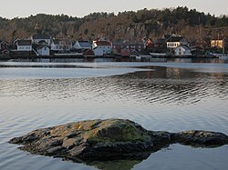
Kalvøysund is a village in Arendal municipality in Aust-Agder county, Norway. The village is located on the eastern shore of the island of Flostaøya, about 2 kilometres (1.2 mi) south of the village of Kilsund and about 3 kilometres (1.9 mi) northeast of the village of Narestø. Kalvøysund was the site of an old German fortress to defend the coastline during the German occupation of Norway.

Kolbjørnsvik is a village in Arendal municipality in Aust-Agder county, Norway. The village is located on the northern part of the island of Hisøya, across the harbour from the town of Arendal. The village of His and the Hisøy Church lie about 2 kilometres (1.2 mi) south of Kolbjørnsvik. The former municipality of Hisøy had its municipal government located in this village. Today, the village is considered to be part of the town of Arendal, so separate population statistics are not kept.
Nedenes is a village in Arendal municipality in Aust-Agder county, Norway. The village is located in the southern part of Arendal, just north of the municipal border with Grimstad. The Norwegian County Road 420 runs through the village heading north to the village of Rød and onwards to the island of Hisøya to the north. Engene Church is located in Nedenes.

Pusnes is a village in Arendal municipality in Aust-Agder county, Norway. The village is located on the southwestern edge of the island of Tromøy, just across the strait from the town of Arendal. There is a ferry that regularly crosses the strait from Pusnes to Arendal. Pusnes is primarily an industrial area.
Sagene is a village in Arendal municipality in Aust-Agder county, Norway. The village is located about 2 kilometres (1.2 mi) northwest of the village of Strengereid in the Moland area of Arendal. The lake Langangsvannet lies just east of the village.

Saltrød is a village in Arendal municipality in Aust-Agder county, Norway. The village is located along the Norwegian County Road 410, about 5 kilometres (3.1 mi) northeast of the town of Arendal and about 2 kilometres (1.2 mi) southwest of the village of Eydehavn. The village lies along the Tromøysundet strait, looking across the water towards the island of Tromøy. Stokken Church is located in Saltrød.

Vrengen is a village in Arendal municipality in Aust-Agder county, Norway. The village is located in the Bjorbekk area of Arendal, along the Norwegian County Road 407, just north of the mouth of the river Nidelva. The Bjorbekk Church lies just northwest of Vrengen and the village of Asdal lies just to the south.
Øyna is a village in Arendal municipality in Aust-Agder county, Norway. The village is located at the far northeastern tip of the island of Tromøy. The village sits about 1.5 kilometres (0.93 mi) south of the village of Narestø on the neighboring island of Flostaøya.

Aust-Agder District Court is a court of first instance under Agder Court of Appeal in Norway. The former district courts of Holt, Nedenes and Sand was incorporated in Aust-Agder District Court from September 2004.

Østre Agder is a district or region in Aust-Agder county in southern Norway. The district covers the eastern, coastal areas of the county including the eight municipalities of Arendal, Tvedestrand, Risør, Grimstad, Gjerstad, Vegårshei, Åmli, and Froland. The city of Arendal is the largest city in the region. Other cities in the district include Tvedestrand, Grimstad, and Risør. This region is bounded by Telemark county to the north, by the Setesdal region to the northwest, and by the Kristiansand Region to the southwest.

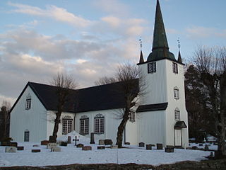
Flosta Church is a parish church in Arendal municipality in Aust-Agder county, Norway. It is located just north of the village of Narestø on the island of Flostaøya. The church is one of three churches that are in the Moland parish which is part of the Arendal prosti (deanery) in the Diocese of Agder og Telemark. The white, wooden church was built around the year 1632 by an unknown architect. The church seats about 300 people.

His is a village in Arendal municipality in Aust-Agder county, Norway. The village is located in the central part of the island of Hisøya, along the Skaggerak coast. The village is the site of the historic Hisøy Church. The main village on the island, Kolbjørnsvik lies about 2 kilometres (1.2 mi) northeast of His, and the city centre of Arendal lies about 5 kilometres (3.1 mi) to the northeast.
Flostaøya is an island in Arendal municipality in Aust-Agder county, Norway. The 7.9-square-kilometre (3.1 sq mi) island lies along the Skaggerak coast between the islands of Tromøy to the southwest and Tverrdalsøya to the northeast. The island lies about 11 kilometres (6.8 mi) northeast of the town of Arendal. Some of the larger villages on the island include Arnevik, Narestø, and Kalvøysund. The island has a bridge connection to the mainland at the southwest corner of the island and there is a bridge connection to Kilsund on the neighboring island of Tverrdalsøya at the north end.