This page is based on this
Wikipedia article Text is available under the
CC BY-SA 4.0 license; additional terms may apply.
Images, videos and audio are available under their respective licenses.
Square kilometre or square kilometer, symbol km2, is a multiple of the square metre, the SI unit of area or surface area.

Offa's Dyke Path is a long-distance footpath following closely the Wales–England border. Opened in 1971, it is one of Britain's National Trails and draws walkers from throughout the world. Some of the 177-mile (285 km) route either follows, or keeps close company with, the remnants of Offa's Dyke, an earthwork, most of which was probably constructed in the late 8th century on the orders of Offa of Mercia.

Emmett Charter Township is a charter township of Calhoun County in the U.S. state of Michigan. It is part of the Battle Creek Metropolitan Statistical Area. The population was 11,770 at the 2010 census.

Naseby is a village in the District of Daventry in Northamptonshire, England. The population of the civil parish at the 2011 Census was 687.

The Daventry District is a local government district in western Northamptonshire, England. The district is named after its main town of Daventry where the council is based.

The Severn Valley is a rural area of mid-western England, through which the River Severn runs and the Severn Valley Railway steam heritage line operates, starting at its northernmost point in Bridgnorth, Shropshire and running south for 16 miles (26 km) to Ribbesford, a few miles south of Bewdley, Worcestershire in the Wyre Forest.
Nortoft was once a distinct hamlet between the Northamptonshire village of Guilsborough and the main road connecting Leicester and Northampton in the English Midlands.

Kaneville Township is one of sixteen townships in Kane County, Illinois, USA. As of the 2010 census, its population was 1,264 and it contained 508 housing units.

May Township is one of seventeen townships in Christian County, Illinois, USA. As of the 2010 census, its population was 1,581 and it contained 668 housing units.
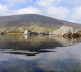
Cloghernagh is a mountain in Wicklow Mountains in County Wicklow, Ireland. On a clear day, to the east you may see Snowdonia in North Wales, roughly 85 miles distant. Cloghernagh is the 40th highest summit in Ireland.

The A153 is a non-primary A road that is located entirely in Lincolnshire in the east of England.
The A586 is a road in England, which runs from Garstang to Blackpool, in Lancashire.
http://www.kuzniewski.netVillage+in+Masovian,+PolandŻochowo+StareVillageCountryFile:Flag+of+Poland.svg+PolandVoivodeshipMasovianCountyPłock+CountyGminaStaroźreby
Żochowo Stare is a village in the administrative district of Gmina Staroźreby, within Płock County, Masovian Voivodeship, in east-central Poland.

The Fish River is a 69.9-mile-long (112.5 km) river in northern Maine in the United States. It is a tributary of the Saint John River, which flows to the Bay of Fundy in New Brunswick, Canada.

Midhurst is an electoral division of West Sussex in the United Kingdom, and returns one member to sit on West Sussex County Council.
Castell Gwallter, also known as Walter's Castle and sometimes Castell Penweddig, is the remains of a Norman motte-and-bailey castle situated on a large hill above the old village of Llandre in northern Ceredigion, Wales, four miles northeast of Aberystwyth.

Big Horn 144A is a First Nations Indian reserve in Alberta, formed in 1948. The 5000-acre reserve is roughly 100 miles north of the settlement of Morley. It is composed of members of the Wesley band of Nakoda (Stoney) Indians.

Cromwell Cottage is a Grade II listed building that stands on a site on the west side of the High Street, just north of its junction with School Lane, in Naseby, Northamptonshire, England.


