
The flat Earth model is an archaic and scientifically disproven conception of Earth's shape as a plane or disk. Many ancient cultures subscribed to a flat Earth cosmography, including Greece until the classical period, the Bronze and Iron Age civilizations of the Near East until the Hellenistic period, and China until the 17th century.

Jordanes, also written as Jordanis or Jornandes, was a 6th-century Eastern Roman bureaucrat widely believed to be of Gothic descent who became a historian later in life. Late in life he wrote two works, one on Roman history (Romana) and the other on the Goths (Getica). The latter, along with Isidore of Seville's Historia Gothorum, is one of only two extant ancient works dealing with the early history of the Goths.

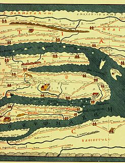
Claudius Ptolemy was a mathematician, astronomer, astrologer, geographer, and music theorist, who wrote about a dozen scientific treatises, three of which were of importance to later Byzantine, Islamic, and Western European science. The first is the astronomical treatise now known as the Almagest, although it was originally entitled the Mathēmatikē Syntaxis or Mathematical Treatise, and later known as The Greatest Treatise. The second is the Geography, which is a thorough discussion on maps and the geographic knowledge of the Greco-Roman world. The third is the astrological treatise in which he attempted to adapt horoscopic astrology to the Aristotelian natural philosophy of his day. This is sometimes known as the Apotelesmatika but more commonly known as the Tetrábiblos, from the Koine Greek meaning "Four Books", or by its Latin equivalent Quadripartite.

Theodoricthe Great, also called Theodoric the Amal, was king of the Ostrogoths (471–526), and ruler of the independent Ostrogothic Kingdom of Italy between 493 and 526, regent of the Visigoths (511–526), and a patrician of the Eastern Roman Empire. As ruler of the combined Gothic realms, Theodoric controlled an empire stretching from the Atlantic Ocean to the Adriatic Sea. Though Theodoric himself only used the title 'king' (rex), some scholars characterize him as a Western Roman Emperor in all but name, since he ruled large parts of the former Western Roman Empire, had received the former Western imperial regalia from Constantinople in 497, and was referred to by the title augustus by some of his subjects.

Scholasticism was a medieval school of philosophy that employed a critical organic method of philosophical analysis predicated upon the Aristotelian 10 Categories. Christian scholasticism emerged within the monastic schools that translated scholastic Judeo—Islamic philosophies, and thereby "rediscovered" the collected works of Aristotle. Endeavoring to harmonize his metaphysics and its account of a prime mover with the Latin Catholic dogmatic trinitarian theology, these monastic schools became the basis of the earliest European medieval universities, and scholasticism dominated education in Europe from about 1100 to 1700. The rise of scholasticism was closely associated with these schools that flourished in Italy, France, Portugal, Spain and England.

Eratosthenes of Cyrene was a Greek polymath: a mathematician, geographer, poet, astronomer, and music theorist. He was a man of learning, becoming the chief librarian at the Library of Alexandria. His work is comparable to what is now known as the study of geography, and he introduced some of the terminology still used today.

The history of geodesy deals with the historical development of measurements and representations of the Earth. The corresponding scientific discipline, geodesy (/dʒiːˈɒdɪsi/), began in pre-scientific antiquity and blossomed during the Age of Enlightenment.

The Mausoleum of Galla Placidia is a Late Antique Roman building in Ravenna, Italy, built between 425 and 450. It was added to the World Heritage List together with seven other structures in Ravenna in 1996. Despite its common name, the empress Galla Placidia was not buried in the building, a misconception dating from the thirteenth century; she died in Rome and was buried there, probably alongside Honorius in the Mausoleum of Honorius at Old Saint Peter's Basilica.
Tabula Peutingeriana, also referred to as Peutinger's Tabula or Peutinger Table, is an illustrated itinerarium showing the layout of the cursus publicus, the road network of the Roman Empire.

The Ravenna Cosmography is a list of place-names covering the world from India to Ireland, compiled by an anonymous cleric in Ravenna around 700 AD. Textual evidence indicates that the author frequently used maps as his source.
The following is a timeline of major event in post-classical history from the 5th to 15th centuries, loosely corresponding to the Old World Middle Ages, intermediate between Late Antiquity and the early modern period.

The Geography, also known by its Latin names as the Geographia and the Cosmographia, is a gazetteer, an atlas, and a treatise on cartography, compiling the geographical knowledge of the 2nd-century Roman Empire. Originally written by Claudius Ptolemy in Greek at Alexandria around AD 150, the work was a revision of a now-lost atlas by Marinus of Tyre using additional Roman and Persian gazetteers and new principles. Its translation into Arabic in the 9th century and Latin in 1406 was highly influential on the geographical knowledge and cartographic traditions of the medieval Caliphate and Renaissance Europe.
Andreas Agnellus of Ravenna was a historian of the bishops in his city. The date of his death is not recorded, although his history mentions the death of archbishop George of Ravenna in 846; Oswald Holder-Egger cites a papyrus charter dated to either 854 or 869 that contains the name of a priest named Andreas of the Church of Ravenna, but there is no evidence to connect him with Andreas Agnellus.

During the Renaissance, great advances occurred in geography, astronomy, chemistry, physics, mathematics, manufacturing, anatomy and engineering. The collection of ancient scientific texts began in earnest at the start of the 15th century and continued up to the Fall of Constantinople in 1453, and the invention of printing allowed a faster propagation of new ideas. Nevertheless, some have seen the Renaissance, at least in its initial period, as one of scientific backwardness. Historians like George Sarton and Lynn Thorndike criticized how the Renaissance affected science, arguing that progress was slowed for some amount of time. Humanists favored human-centered subjects like politics and history over study of natural philosophy or applied mathematics. More recently, however, scholars have acknowledged the positive influence of the Renaissance on mathematics and science, pointing to factors like the rediscovery of lost or obscure texts and the increased emphasis on the study of language and the correct reading of texts.
An ijazah is a license authorizing its holder to transmit a certain text or subject, which is issued by someone already possessing such authority. It is particularly associated with transmission of Islamic religious knowledge. The license usually implies that the student has acquired this knowledge from the issuer of the ijaza through first-hand oral instruction, although this requirement came to be relaxed over time. An ijaza providing a chain of authorized transmitters going back to the original author often accompanied texts of hadith, fiqh and tafsir; but also appeared in mystical, historical, and philological works, as well as literary collections. While the ijaza is primarily associated with Sunni Islam, the concept also appears in the hadith traditions of Twelver Shia.
Medieval Islamic geography and cartography refer to the study of geography and cartography in the Muslim world during the Islamic Golden Age. Muslim scholars made advances to the map-making traditions of earlier cultures, particularly the Hellenistic geographers Ptolemy and Marinus of Tyre, combined with what explorers and merchants learned in their travels across the Old World (Afro-Eurasia). Islamic geography had three major fields: exploration and navigation, physical geography, and cartography and mathematical geography. Islamic geography reached its apex with Muhammad al-Idrisi in the 12th century.

Judith Herrin, is a British archaeologist and academic of Late Antiquity. She was Professor of Late Antique and Byzantine Studies and Constantine Leventis Senior Research Fellow at King's College London.

European science in the Middle Ages comprised the study of nature, mathematics and natural philosophy in medieval Europe. Following the fall of the Western Roman Empire and the decline in knowledge of Greek, Christian Western Europe was cut off from an important source of ancient learning. Although a range of Christian clerics and scholars from Isidore and Bede to Jean Buridan and Nicole Oresme maintained the spirit of rational inquiry, Western Europe would see a period of scientific decline during the Early Middle Ages. However, by the time of the High Middle Ages, the region had rallied and was on its way to once more taking the lead in scientific discovery. Scholarship and scientific discoveries of the Late Middle Ages laid the groundwork for the Scientific Revolution of the Early Modern Period.
The Lupenians or Lpins were a historical tribe that lived in modern-day Republic of Azerbaijan in antiquity. The Lupenians were mentioned in several sources in different languages. They are equated with Pliny's Lupenii, dwelling south of the tribe of Silvii (Chola), just next to the Diduri and near the frontier of Caucasian Albania. Agathangelos renders their name in Greek as Lifénnioi. The Ravenna Cosmography mentions their land as "Patria Lepon" situated next to Iberia and the Caspian Sea. The Tabula Peutingeriana also mentions the Lupenii. Vladimir Minorsky proposed later Arabic versions as well. They were probably related to the Caucasian Albanians.