Related Research Articles
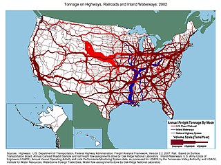
Transportation in the United States is facilitated by road, air, rail, and waterways. The vast majority of passenger travel occurs by automobile for shorter distances, and airplane for longer distances. In descending order, most cargoes travel by railroad, truck, pipeline, or boat; air shipping is typically used only for perishables and premium express shipments. Transportation is the largest source of greenhouse gas emissions by the United States.

The Dwight D. Eisenhower National System of Interstate and Defense Highways, commonly known as the Interstate Highway System, is a network of controlled-access highways that forms part of the National Highway System in the United States. The system extends throughout the contiguous United States and has routes in Hawaii, Alaska, and Puerto Rico.

In transportation, platooning or flocking is a method for driving a group of vehicles together. It is meant to increase the capacity of roads via an automated highway system.
American Automobile Association is a federation of motor clubs throughout North America. AAA is a privately held not-for-profit national member association and service organization with over 60 million members in the United States and Canada. AAA provides services to its members, including roadside assistance and others. Its national headquarters are in Heathrow, Florida.
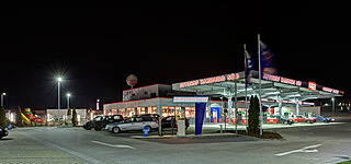
A rest area is a public facility located next to a large thoroughfare such as a motorway, expressway, or highway, at which drivers and passengers can rest, eat, or refuel without exiting onto secondary roads. Other names include motorway service area (UK), services (UK), travel plaza, rest stop, oasis (US), service area, rest and service area (RSA), resto, service plaza, lay-by, and service centre (Canada). Facilities may include park-like areas, fuel stations, public toilets, water fountains, restaurants, and dump and fill stations for caravans / motorhomes.

The Ohio Turnpike, officially the James W. Shocknessy Ohio Turnpike, is a 241.26-mile-long (388.27 km) limited-access toll highway in the U.S. state of Ohio, serving as a primary corridor between Chicago and Pittsburgh. The road runs east–west in the northern section of the state, with the western end at the Indiana–Ohio border near Edon where it meets the Indiana Toll Road, and the eastern end at the Ohio–Pennsylvania border near Petersburg, where it meets the Pennsylvania Turnpike. The road is owned and maintained by the Ohio Turnpike and Infrastructure Commission (OTIC), headquartered in Berea.
The Federal Highway Administration (FHWA) is a division of the United States Department of Transportation that specializes in highway transportation. The agency's major activities are grouped into two programs, the Federal-aid Highway Program and the Federal Lands Highway Program. Its role had previously been performed by the Office of Road Inquiry, Office of Public Roads and the Bureau of Public Roads.

An Illinois Tollway oasis is a type of commercialized rest area sited over Interstate Highways that are part of the Illinois Tollway system in northern Illinois, United States. The four oases offer food and gasoline vendors and are found in the Chicago Metropolitan Area, DeKalb, and Belvidere. Although the oases date back to the original tollway construction in 1958, they were redeveloped in 2003–2005 by Wilton Partners, a private developer. The redevelopment of the oases has been the focal point of alleged political corruption. The four oases are administered by a court-appointed manager following default of Wilton Partners.

The National Highway System (NHS) is a network of strategic highways within the United States, including the Interstate Highway System and other roads serving major airports, ports, military bases, rail or truck terminals, railway stations, pipeline terminals and other strategic transport facilities. Altogether, it constitutes the largest highway system in the world.
The Connecticut Turnpike is a controlled-access highway and former toll road in the U.S. state of Connecticut; it is maintained by the Connecticut Department of Transportation (ConnDOT). Spanning approximately 128 miles (206 km) along a generally west–east axis, its roadbed is shared with Interstate 95 (I-95) for 88 miles (142 km) from the New York state border in Greenwich to East Lyme; I-395 for 36 miles (58 km) from East Lyme to Plainfield; and State Road 695 (SR 695) for four miles (6.4 km) from Plainfield to the Rhode Island state line at U.S. Route 6 (US 6) in Killingly. The turnpike briefly runs concurrently with US 1 from Old Saybrook to Old Lyme and Route 2A from Montville to Norwich.

Interstate 95 (I-95) is a part of the Interstate Highway System that runs north–south from Miami, Florida to Houlton, Maine. The highway enters Maine from the New Hampshire state line in Kittery and runs for 303 miles (488 km) to the Canadian border in Houlton. It is the only primary Interstate Highway in Maine. In 2004, the highway's route between Portland and Gardiner was changed so that it encompasses the entire Maine Turnpike, a toll road running from Kittery to Augusta.
Interstate 95 (I-95) is an Interstate Highway running along the East Coast of the United States from Miami, Florida, north to the Canadian border in Houlton, Maine. In the state of Delaware, the route runs for 23.43 miles (37.71 km) across the Wilmington area in northern New Castle County from the Maryland state line near Newark northeast to the Pennsylvania state line in Claymont. I-95 is the only primary Interstate Highway that enters Delaware, although it also has two auxiliary routes within the state. Between the Maryland state line and Newport, I-95 follows the Delaware Turnpike, a toll road with a mainline toll plaza near the state line. Near Newport, the Interstate has a large interchange with Delaware Route 141 (DE 141) and the southern termini of I-295 and I-495. I-95 heads north through Wilmington concurrent with U.S. Route 202 (US 202) on the Wilmington Expressway. Past Wilmington, I-95 continues northeast to Claymont, where I-495 rejoins the route right before the Pennsylvania state line.

The National Maximum Speed Limit (NMSL) was a provision of the federal government of the United States 1974 Emergency Highway Energy Conservation Act that effectively prohibited speed limits higher than 55 miles per hour (89 km/h). It was drafted in response to oil price spikes and supply disruptions during the 1973 oil crisis and remained the law until 1995.

Interstate 75 (I-75) is a part of the Interstate Highway System that runs from the Hialeah–Miami Lakes border, a few miles northwest of Miami, to Sault Ste. Marie in the Upper Peninsula of Michigan. I-75 begins its national northward journey near Miami, running along the western parts of the Miami metropolitan area before traveling westward across Alligator Alley, resuming its northward direction in Naples, running along Florida's Gulf Coast, and passing the cities of Fort Myers, Punta Gorda, Venice, and Sarasota. The freeway passes through the Tampa Bay area before turning inward toward Ocala, Gainesville, and Lake City before leaving the state and entering Georgia. I-75 runs for 471 miles (758 km) in Florida, making it the longest Interstate in the state and also the longest in any state east of the Mississippi River. The Interstate's speed limit is 70 mph (110 km/h) for its entire length in Florida.

Interstate 84 (I-84) in the U.S. state of Idaho is a major Interstate Highway that traverses the state from the Oregon state line in the northwest to Utah state line in the southeast. It primarily follows the Snake River across a plain that includes the cities of Boise, Mountain Home, and Twin Falls. The highway is one of the busiest in Idaho and is designated as the Vietnam Veterans Memorial Highway.
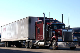
The trucking industry serves the American economy by transporting large quantities of raw materials, works in process, and finished goods over land—typically from manufacturing plants to retail distribution centers. Trucks are also used in the construction industry, two of which require dump trucks and portable concrete mixers to move the large amounts of rocks, dirt, concrete, and other building materials used in construction. Trucks in America are responsible for the majority of freight movement over land and are tools in the manufacturing, transportation, and warehousing industries.

The trucking industry in the United States has affected the political and economic history of the United States in the 20th century. Before the invention of automobiles, most freight was moved by train or horse-drawn vehicle.

The Dixie Travel Plaza, previously known as the Dixie Truck Stop and Dixie Trucker's Home, is a large trucker and travel plaza located in McLean, Illinois, on Interstate 55. It was established by J.P. Walters and John Geske in 1928 on old US Route 66 as a small sandwich stand in a truck mechanic's garage. By 1930, quickly growing demand had necessitated expansion into a full-size restaurant. The restaurant was expanded several times afterwards, and rebuilt once after a fire in 1965. Walters, Geske and the Dixie Trucker's Home have been recognized by the Route 66 Association of Illinois for their contributions—from 1926 to 1977—to the character of Route 66. They were inducted into the association's hall of fame on June 9, 1990. Dixie was previously home to the Route 66 Hall of Fame when it opened in 1990. In 2003, after Dixie changed ownership, the museum was moved to a new, larger location in Pontiac, Illinois.
The Indiana Toll Road, officially the Indiana East–West Toll Road, is a tolled freeway that runs for 156.28 miles (251.51 km) east–west across northern Indiana from the Illinois state line to the Ohio state line. It has been advertised as the "Main Street of the Midwest". The entire toll road is designated as part of Interstate 90 (I-90), and the segment from Lake Station east to the Ohio state line is a concurrency with I-80. The toll road is owned by the Indiana Finance Authority and operated by the Indiana Toll Road Concession Company (ITRCC), which is owned by IFM Investors.
The Delaware State Route System consists of roads in the U.S. state of Delaware that are maintained by the Delaware Department of Transportation (DelDOT). The system includes the portions of the Interstate Highway System and United States Numbered Highways system located in the state along with state routes and other roads maintained by DelDOT. All roads maintained by the state are assigned a maintenance road number that is only marked on little white markers at intersections and on auxiliary plates below warning signs approaching intersections. These numbers are only unique in a specific county; some roads can be designated with multiple road numbers, and numbers do not necessarily correspond to the signed Interstate, U.S., or state route numbers. DelDOT maintains a total of 5,386.14 miles (8,668.15 km) of roads, comprising 89 percent of the roads within the state. Some large bridges in the state are maintained by other agencies including the U.S. Army Corps of Engineers and the Delaware River and Bay Authority. Roads in the system include multilane freeways, multilane surface divided highways, and two-lane undivided roads serving urban, suburban, and rural areas. Some of the roads maintained by DelDOT are toll roads, in which motorists must pay to use.
References
- ↑ "About NATSO". NATSO. 2019. Retrieved April 24, 2019.
- ↑ "Stop Watch - Library". NATSO. Retrieved April 24, 2019.