Related Research Articles
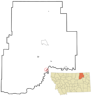
Fort Peck is a town in Valley County, Montana, United States. The population was 239 at the 2020 census.

The James River is a river in Virginia that begins in the Appalachian Mountains and flows from the confluence of the Cowpasture and Jackson Rivers in Botetourt County 348 miles (560 km) to the Chesapeake Bay. The river length extends to 444 miles (715 km) if the Jackson River, the longer of its two headwaters, is included. It is the longest river in Virginia. Jamestown and Williamsburg, Virginia's first colonial capitals, and Richmond, Virginia's current capital, lie on the James River.

Bonneville Lock and Dam consists of several run-of-the-river dam structures that together complete a span of the Columbia River between the U.S. states of Oregon and Washington at River Mile 146.1. The dam is located 40 miles (64 km) east of Portland, Oregon, in the Columbia River Gorge. The primary functions of Bonneville Lock and Dam are electrical power generation and river navigation. The dam was built and is managed by the United States Army Corps of Engineers. At the time of its construction in the 1930s it was the largest water impoundment project of its type in the nation, able to withstand flooding on an unprecedented scale. Electrical power generated at Bonneville is distributed by the Bonneville Power Administration. Bonneville Dam is named for Army Capt. Benjamin Bonneville, an early explorer credited with charting much of the Oregon Trail. The Bonneville Dam Historic District was designated a National Historic Landmark District in 1987.

The Mystic River is a 7.0-mile-long (11.3 km) river in Massachusetts. In the Massachusett language, missi-tuk means "large estuary", alluding to the tidal nature of the Mystic River. The resemblance to the English word mystic is a coincidence, which the colonists followed.
Lake Mead National Recreation Area is a U.S. national recreation area in Southeastern Nevada and Northwestern Arizona. Operated by the National Park Service, Lake Mead NRA follows the Colorado River corridor from the westernmost boundary of Grand Canyon National Park to just north of the cities of Laughlin, Nevada and Bullhead City, Arizona. It includes all of the eponymous Lake Mead as well as the smaller Lake Mohave – reservoirs on the river created by Hoover Dam and Davis Dam, respectively – and the surrounding desert terrain and wilderness.

The Youghiogheny River, or the Yough for short, is a 134-mile-long (216 km) tributary of the Monongahela River in West Virginia, Maryland, and Pennsylvania. It drains an area on the west side of the Allegheny Mountains northward into Pennsylvania, providing a small watershed in extreme western Maryland into the tributaries of the Mississippi River. Youghiogheny is a Lenape word meaning "a stream flowing in a contrary direction".
The St. Joseph River is a 210-mile-long (340 km) river that flows in a generally westerly direction through southern Michigan and northern Indiana, United States, before emptying into Lake Michigan. The St. Joseph River drainage basin covers 4,685 square miles (12,130 km2), and is the third largest watershed draining to Lake Michigan. The land within its bounds is primarily used for agriculture. The river and its tributaries provide a variety of paddling and fishing environments. Historically, the river served as an important canoe transportation route for various Native American tribes, and for French Canadian Voyageurs.

The Farmington River is a river, 46.7 miles (75.2 km) in length along its main stem, located in northwest Connecticut with major tributaries extending into southwest Massachusetts. The longest route of the river, from the origin of its West Branch, is 80.4 miles (129.4 km) long, making it the Connecticut River's longest tributary by 2.3 miles (3.7 km) over the Westfield River directly to its north. The Farmington River's watershed covers 609 square miles (1,580 km2). Historically, the river played an important role in small-scale manufacturing in towns along its course, but it is now mainly used for recreation and drinking water.

This is intended to be a complete list of the properties and districts on the National Register of Historic Places in Fairfield County, Connecticut, United States. The locations of National Register properties and districts for which the latitude and longitude coordinates are included below may be seen in an online map.

Dry Creek is a 43.0-mile-long (69.2 km) stream in the California counties of Sonoma and Mendocino. It is a tributary of the Russian River, with headwaters in Mendocino County.

The Frankstown Branch Juniata River is a 46.0-mile-long (74.0 km) tributary of the Juniata River in Blair and Huntingdon counties, Pennsylvania, in the United States.

The Raystown Branch Juniata River is the largest and longest tributary of the Juniata River in south-central Pennsylvania in the United States.

The Presumpscot River is a 25.8-mile-long (41.5 km) river located in Cumberland County, Maine, United States. It is the main outlet of Sebago Lake. The river provided an early transportation corridor with reliable water power for industrial development of the city of Westbrook and the village of South Windham.
Deer Creek is a 52.9-mile-long (85.1 km) river in Maryland and Pennsylvania that flows through the scenic areas of Harford County and empties into the Susquehanna River, roughly halfway between the Interstate 95 bridge and Conowingo Dam. Its watershed area is 171 square miles (440 km2). Its watershed area in MD is 145 square miles (380 km2), with 3% impervious surface in 1994. It serves as a divider between the agricultural and urban/suburban areas of Harford County.

Johnsville is an unincorporated community in Frederick County, Maryland, United States. It is located approximately halfway between Libertytown and Union Bridge along Maryland Route 75. The Kitterman-Buckey Farm was listed on the National Register of Historic Places in 2005.
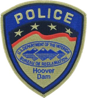
The Hoover Dam Police, officially the Bureau of Reclamation Police, was a federal security police force, stationed at Hoover Dam 23 miles (37 km) southeast of Las Vegas under the command of the US Bureau of Reclamation. Reclamation Police Officers were stationed only at Hoover Dam. Hoover Dam was both listed on the National Register of Historic Places in 1981, and was designated a National Historic Landmark in 1985. Hoover Dam has been designated as National Critical Infrastructure. The primary responsibilities of the Hoover Dam Police Officer were to protect the dam, the world's 57th-largest hydroelectric generating station, which provides about 2,080 megawatts, its associated structures, and to safeguard the lives of visitors and employees. The Hoover Dam Police were assisted by unarmed Bureau of Reclamation security guards who control access to reclamation facilities and deter individuals who might consider criminal activities or terrorist acts.
Normandy Dam is a dam built by the Tennessee Valley Authority (TVA) on the Duck River in the U.S. state of Tennessee. It straddles the border between Bedford and Coffee counties. Completed in 1976, the dam was built primarily for flood control and economic development purposes, and does not produce any electricity. The town of Normandy is located just southwest of the dam. The water level in Normandy Reservoir varies about 11 feet in a normal year.

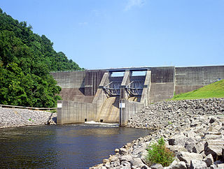
Part of the Uncompahgre Project located on the western slope of central Colorado, the Taylor Park Dam was engineered by the Bureau of Reclamation. It is located on the Taylor River, a tributary of the Gunnison River, and the dam is used to create the Taylor Park Reservoir in Gunnison County, Colorado. The dam has National Inventory of Dams ID number CO00151.
References
- 1 2 3 "National Inventory of Dams" (html). Data.gov . U.S. Government . Retrieved 24 September 2017.
 This article incorporates text from this source, which is in the public domain .