
The Geography Markup Language (GML) is the XML grammar defined by the Open Geospatial Consortium (OGC) to express geographical features. GML serves as a modeling language for geographic systems as well as an open interchange format for geographic transactions on the Internet. Key to GML's utility is its ability to integrate all forms of geographic information, including not only conventional "vector" or discrete objects, but coverages and sensor data.

A bus stop is a designated place where buses stop for passengers to get on and off the bus. The construction of bus stops tends to reflect the level of usage, where stops at busy locations may have shelters, seating, and possibly electronic passenger information systems; less busy stops may use a simple pole and flag to mark the location. Bus stops are, in some locations, clustered together into transport hubs allowing interchange between routes from nearby stops and with other public transport modes to maximise convenience.

The Department for Transport (DfT) is the government department responsible for the English transport network and a limited number of transport matters in Scotland, Wales and Northern Ireland that have not been devolved. The department is run by the Secretary of State for Transport, currently Grant Shapps.

The National Public Transport Access Node (NaPTAN) database is a UK nationwide system for uniquely identifying all the points of access to public transport in the UK. The database is closely associated with the National Public Transport Gazetteer.
The e-Government Metadata Standard, e-GMS, is the UK e-Government Metadata Standard. It defines how UK public sector bodies should label content such as web pages and documents to make such information more easily managed, found and shared.
The transport system in Scotland is generally well-developed. The Scottish Parliament has control over most elements of transport policy within Scotland, with the Cabinet Secretary for Transport, Infrastructure and Connectivity holding portfolio responsibility within the Scottish Government. Transport Scotland is the Executive Agency responsible for the Scottish transport network.
The Integrated Transport Network (ITN) is a dataset containing details of Great Britain's transport network. Produced by Ordnance Survey – the national mapping agency of Great Britain – it forms part of the OS MasterMap suite of products.

The Transport Direct Programme was a division of the UK Department for Transport (DfT) to develop standards, data and better information technology systems to support public transport. It developed and operates the Transport Direct Portal which is a public facing multi-modal journey planner. It also supports the creation and management of comprehensive databases of all public transport movements in the United Kingdom with Traveline. During 2010 two key datasets were released as Open Data and published on www.data.gov.uk.
The Scottish Ambulance Service is part of NHS Scotland, which serves all of Scotland's population., The Scottish Ambulance Service is governed by a special health board and is funded directly by the Health and Social Care Directorates of the Scottish Government.
JourneyWeb is an XML protocol to allow distributed journey planning engines to communicate in order to provide multimodal journeys spanning different regions.
TransXChange is a UK national XML based data standard for the interchange of bus route and timetable information between bus operators, the Vehicle and Operator Services Agency, local authorities and passenger transport executives, and others involved in the provision of passenger information.
The Standard Interface for Real-time Information or SIRI is an XML protocol to allow distributed computers to exchange real-time information about public transport services and vehicles.
Transmodel is the CEN European Reference Data Model for Public Transport Information; it provides a conceptual model of common public transport concepts and data structures that can be used to build many different kinds of public transport information system, including for timetabling, fares, operational management, real time data, journey planning etc.
IFOPT is a CEN Technical Specification that provides a Reference Data Model for describing the main fixed objects required for public access to Public transport, that is to say Transportation hubs. Such a model is a fundamental component of the modern Public transport information systems needed both to operate Public transport and to inform passengers about services.
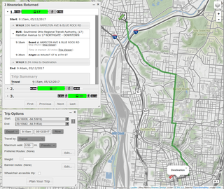
A journey planner, trip planner, or route planner is a specialized search engine used to find an optimal means of travelling between two or more given locations, sometimes using more than one transport mode. Searches may be optimized on different criteria, for example fastest, shortest, fewest changes, cheapest. They may be constrained, for example, to leave or arrive at a certain time, to avoid certain waypoints, etc. A single journey may use a sequence of several modes of transport, meaning the system may know about public transport services as well as transport networks for private transportation. Trip planning or journey planning is sometimes distinguished from route planning, where route planning is typically thought of as using private modes of transportation such as cycling, driving, or walking, normally using a single mode at a time. Trip or journey planning, in contrast, would make use of at least one public transport mode which operates according to published schedules; given that public transport services only depart at specific times, an algorithm must therefore not only find a path to a destination, but seek to optimize it so as to minimize the waiting time incurred for each leg. In European Standards such as Transmodel, trip planning is used specifically to describe the planning of a route for a passenger, to avoid confusion with the completely separate process of planning the operational journeys to be made by public transport vehicles on which such trips are made.

Denshaw is a village in Saddleworth—a civil parish of the Metropolitan Borough of Oldham, in Greater Manchester, England. It lies by the source of the River Tame, high amongst the Pennines above the village of Delph, 4.6 miles (7.4 km) northeast of Oldham,3.3 miles (5.3 km) north-northwest of Uppermill and Shaw and Crompton. It has a population of around 500.
CycleNetXChange provides a standard format with which to exchange cycle path data, together with information about the quality of routes; This enables computerised transport systems to provide cycle routes.

Traveline is a public transport route planner service provided by a partnership between local authorities and transport operators in the UK to provide impartial and comprehensive information about public transport which has operated since 2000. It prepares comprehensive public transport data for the UK and provides a number of regional public transport journey planners.
Crown Copyright has been a long-standing copyright protection applied to official works, and at times artistic works, produced under royal or official supervision. In 2006, The Guardian newspaper's Technology section began a "Free Our Data" campaign, calling for data gathered by authorities at public expense to be made freely available for reuse by individuals. In 2010 with the creation of the Open Government Licence and the Data.gov.uk site it appeared that the campaign had been mostly successful, and since 2013 the UK has been consistently named one of the leaders in the open data space.
NeTEx is the CEN Technical standard for exchanging Public Transport Information as XML documents. it provides a W3C XML schema based on the Transmodel abstract model of common public transport concepts and data structures and can be used to exchange many different kinds of data between passenger information systems, including data describing for stops, facilities, timetabling and fares. Such data can be used by both operational management systems and customer facing systems for journey planning etc.