Kampong Speu is a province (khaet) of Cambodia. It borders the provinces of Pursat and Kompong Chhnang to the north, Kandal to the east, Takéo to the southeast, Kampot to the south and Koh Kong to the west. Its capital is Chbarmorn town.

Prey Chhor District is a district (srok) located in Kampong Cham Province, Cambodia. The district capital is Prey Totueng town located around 29 kilometres east of the provincial capital of Kampong Cham and 95 kilometres north west of Phnom Penh by road. Prey Chhor is a central district of Kampong Cham and is surrounded by other Kampong Cham districts.
Ou Reang Ov District is a district (srok) located in Tboung Khmum Province, Cambodia. The district capital is Ou Reang Ov town located around 30 kilometres south of the provincial capital of Kampong Cham by road. Ou Reang Ov lies on the border where Tboung Khmum, Kampong Cham and Prey Veng provinces meet; the town of Prey Veng is only 42 kilometres away by road.
Batheay District is a district (srok) of Kampong Cham Province, Cambodia. The district capital is Ph'av town. The town is located on National Highway 6 around 64 kilometres east of the provincial capital at Kampong Cham city and 60 kilometres north of the Cambodian capital Phnom Penh. The district lies at the junction between two major waterways, the Mekong River and the Tonle Sap.
Phnum Kravanh district is a district in Pursat Province, Cambodia. In English the name translates to the Cardamom Mountains.
Krakor District is a district in Pursat Province, Cambodia. The district capital is Krakor town located 25 kilometres east of the provincial capital, Pursat town.
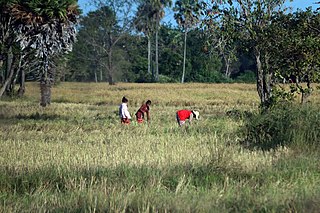
Borsedth District is a district (srok) in the south of Kampong Speu Province, in southern Cambodia. The district capital is Borsedth town located some 50 kilometres south of the provincial capital of Kampong Speu by road. The district shares a border with Kampot and Takeo provinces to the south.National Highway 3 forms the eastern district boundary. The district is made up of flat farmland and supports extensive agriculture and a large population.
Baribour District is a district (srok) in the north of Kampong Chhnang Province, in central Cambodia. The district capital is Baribour town located around 38 kilometres north west of the provincial capital of Kampong Chhnang by road. The district shares a border with Pursat Province to the west and with Kampong Thom Province to the north. The district borders on the Tonle Sap and the Tonle Sap river forms the northern and eastern borders of the district.
Chol Kiri District is a district (srok) in the east of Kampong Chhnang Province, in central Cambodia. The district capital is Chol Kiri town located around 8 kilometres south of the provincial capital of Kampong Chhnang by road. Chol Kiri District is the easternmost district of Kampong Chhnang. The district shares a border with Kampong Thom and Kampong Cham provinces to the east. Most of the district is low lying floodplain and the Tonlé Sap river runs through the district roughly from north to south. This proximity to the river and the lack of high land make Chol Kiri one of the most flood prone districts in the country. The Kampong Chhnang Department of Development has estimated that both Chol Kiri and Kampong Leaeng districts are flooded for six months of the year and that after the floodwaters have receded drinking water sources are left contaminated.
Kampong Leaeng District is a district (srok) in the north east of Kampong Chhnang Province, in central Cambodia. The district capital is Kampong Leaeng town located around 4 kilometres east of the provincial capital of Kampong Chhnang in a direct line. Kampong Leaeng District is the northernmost district of Kampong Chhnang. The district shares a border with Kampong Thom province to north and east. Much of the district is low-lying floodplain and the Tonle Sap river runs through the district roughly from north to south. In the south of the district are two significant mountains. Phnom Chrak Tunling and Phnom Neang Kangrei both over 1000 metres in elevation.

Kampong Tralach District is a district (srok) in the south east of Kampong Chhnang Province, in central Cambodia. The district capital is Kampong Tralach town located 37 kilometres south of the provincial capital of Kampong Chhnang by road. The district shares a border with Kandal province to the south and Kampong Cham province to the east. The Tonle Sap river runs through the district crossing roughly from north to south.

Rolea B'ier District is a district (srok) in the center of Kampong Chhnang Province, in central Cambodia. The district capital is Rolea B'ier, a town located 5 kilometres south of the provincial capital of Kampong Chhnang. The district is surrounded by other Kampong Chhnang districts and in turn surrounds Kampong Chhnang District which includes the provincial capital. The Tonle Sap serves as the border of the district in the north east. The Kampong Chhnang Airport, built during the period of Democratic Kampuchea lies in Krang Leav commune.
Sameakki Mean Chey District is a district (srok) in the south of Kampong Chhnang Province, in central Cambodia. The district capital is Sameakki Mean Chey town located on the rail line some 52 kilometres south of the provincial capital of Kampong Chhnang by road. The district shares a border with Kandal and Kampong Speu provinces to the south. The National Railway line from Phnom Penh to Sisophon runs through the district crossing roughly from north to south.

Tuek Phos District is a district (srok) in the west of Kampong Chhnang Province, in central Cambodia. The district capital is Tuek Phos town located on the rail line some 28 kilometres south west of the provincial capital of Kampong Chhnang by road. The district shares a border with Pursat and Kampong Speu provinces to the west. The National Railway line from Phnom Penh to Sisophon runs through the district entering in the south and exiting in the north west.
National Highway 5 or National Road No.5 (10005) is one of the national highways of Cambodia. With a length of 407.45 km (253.18 mi), it connects the capital of Phnom Penh with Thailand. NH5 leaves Phnom Penh in a north to northwest direction, it first borders the Tonle Sap, three bridges the Chroy Changvar, the Prek Kdam and the Prek Pnov link the Est of the country. Then it moves away from the river/lake because the land there is flooded part of the year and it exits Kandal Province and traverses Kampong Chhnang Province from the junction with Road 51, north to Kampong Chhnang City, then northwest to Baribour District where it crosses into Pursat Province. From there, it skirts the Tonle Sap lake and continues west to Pursat town, the provincial capital. Leaving Pursat, NH5 again turns northwest and leads to Battambang Province, passing through another provincial capital at Battambang city and continuing on to Serei Saophoan District in Banteay Meanchey Province where it meets the terminus of NH6 and bends westward towards its own terminus at Poipet on the Thai border.
Bavel is a khum (commune) of Bavel District in Battambang Province in north-western Cambodia.
Kampong Chhnang District is a district (srok) in the centre of Kampong Chhnang Province in central Cambodia. This is classed as an urban district and the provincial capital Kampong Chhnang lies within the district. The town is also the capital of the district. The district is quite small and encompasses the provincial town and nearby communes. Kampong Chhnang is the smallest district in Kampong Chhnang province and is surrounded by other Kampong Chhnang districts. The Tonle Sap river lies on the north and eastern borders of the district.
Phumĭ Phsa Rôméas is a small town in Tuek Phos District in Kampong Chhnang Province, Cambodia. The town is connected to Kampong Chhnang in the north by National Road 53. The National Road 142 begins to the south-west of the town and connects it to National Road 138.