Related Research Articles
A state highway, state road, or state route is usually a road that is either numbered or maintained by a sub-national state or province. A road numbered by a state or province falls below numbered national highways in the hierarchy. Roads maintained by a state or province include both nationally numbered highways and un-numbered state highways. Depending on the state, "state highway" may be used for one meaning and "state road" or "state route" for the other.

U.S. Route 20 or U.S. Highway 20 (US 20) is an east–west United States Numbered Highway that stretches from the Pacific Northwest east to New England. The "0" in its route number indicates that US 20 is a major coast-to-coast route. Spanning 3,365 miles (5,415 km), it is the longest road in the United States, and, in the east, the route is roughly parallel to that of the newer Interstate 90 (I-90), which is the longest Interstate Highway in the U.S. There is a discontinuity in the official designation of US 20 through Yellowstone National Park, with unnumbered roads used to traverse the park.

U.S. Route 40 or U.S. Highway 40 (US 40), also known as the Main Street of America, is a major east–west United States Highway traveling across the United States from the Mountain States to the Mid-Atlantic States. As with most routes whose numbers end in a zero, US 40 once traversed the entire United States. It is one of the first U.S. Highways created in 1926 and its original termini were in San Francisco, California and Atlantic City, New Jersey. In the western United States, US 40 was functionally replaced by Interstate 80 (I-80), resulting in the route being truncated multiple times. US 40 currently ends at a junction with I-80 in Silver Summit, Utah, just outside Salt Lake City.

U.S. Route 50 or U.S. Highway 50 (US 50) is a major east–west route of the U.S. Highway system, stretching 3,073 miles (4,946 km) from Interstate 80 (I-80) in West Sacramento, California, to Maryland Route 528 in Ocean City, Maryland, on the Atlantic Ocean. Until 1972, when it was replaced by Interstate Highways west of the Sacramento area, it extended to San Francisco, near the Pacific Ocean. The Interstates were constructed later and are mostly separate from this route. It generally serves a corridor south of I-70 and I-80 and north of I-64 and I-40.

The Newell Highway is a national highway in New South Wales (NSW), Australia. It provides the major road link between southeastern Queensland and Victoria via central NSW and as such carries large amounts of freight. At 1,058 kilometres (657 mi) in length, the Newell is the longest highway in NSW, and passes through fifteen local government areas. The highway is part of Australian national route 39 and was signposted accordingly until 2013. Since then it has been signposted as NSW route A39.

The National highways in India are a network of trunk roads owned by the Ministry of Road Transport and Highways. It is constructed and managed by the National Highway Authority of India (NHAI), the National Highways and Infrastructure Development Corporation Limited (NHIDCL), and the public works departments (PWD) of state governments. Currently, the longest National Highway in India is National Highway 44 at 3,508 km.

The Lyell Highway is a highway in Tasmania, running from Hobart to Queenstown. It is the one of two transport routes that passes through the West Coast Range, the other being the Anthony Road.

National Highway 63, is a National Highway in India, total length 860 km (530 mi) that connects Nizamabad in Telangana and Jagdalpur in Chhattisgarh. It passes through the states of Telangana, Maharashtra and Chhattisgarh.
Sameakki Mean Chey is a district (srok) in the south of Kampong Chhnang province, in central Cambodia. The district capital is Sameakki Mean Chey town located on the rail line some 52 kilometres south of the provincial capital of Kampong Chhnang by road. The district shares a border with Kandal and Kampong Speu provinces to the south. The National Railway line from Phnom Penh to Sisophon runs through the district crossing roughly from north to south.
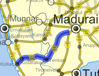
National Highway 744 or NH 744 is a National Highway in Southern India that links Kollam (Quilon) in Kerala with Madurai in Tamil Nadu. Starting from NH 66 at Chinnakkada in Kollam, it joins Tirumangalam in Madurai at National Highway 44 (India).

National Route 396 is a national highway of Japan connecting Tōno, Iwate and Morioka, Iwate in Japan, with a total length of 58.7 km (36.47 mi).

National Highway 766 is a National Highway in Southern India. NH 766 connects Kozhikode in Kerala with Kollegal in Karnataka via Mysore. Of the total distance of 272 km, 117 km is in Kerala and 155 is in Karnataka. At Kollegal, it joins National Highway 948, which connects Bengaluru and Coimbatore. The highway passes through dense forests of Western ghats of India. The NH-766 passes through 19.7 km Bandipur National Park and Wayanad wild life sanctuary.
National Highways 183 is located in India. It connects Kollam High school Jn in Kerala with Dindigul in Tamil Nadu. Starting from Kollam it runs northwards and turns east at Kottayam and runs along the northern border of Periyar Wildlife Sanctuary before crossing the border into Tamil Nadu and end near Dindigul, where it joins NH 83(Coimbatore - Nagapattinam). This highway was previously known as NH 220.
National Highway 183A, also known as NH 183A, is a National Highway in the Indian state of Kerala that runs from Chavara Titanium JunctionKollam, to Vandiperiyar via Adoor and Pathanamthitta. It is the 4th National Highway passing through the Kollam district.
National Highway 52, Sangrur, Punjab to Ankola, Karnataka, is a National Highway in India. The national highway 52 was numbered after amalgamating many existing national highways of India. The old highway numbered NH-63 was from Ankola in Karnataka state to Gooty in Andhra pradesh state. The highway 52 starts at the junction of National Highway 66 at Ankola and moves up to Arebail ghat of Western ghats and then to Yellapura and further to Hubbali (Hubli). Some stretch of old national highway 13 from Vijayapura to Solapur was joined with NH-52.
National Highway 161,, is a National Highway in India running through the states of Maharashtra and Telangana of India. The National Highway 161 joins the cities of Akola, Washim, Hingoli, Nanded, Degloor, Bichkunda, Pitlam, Narayana Khed,Shankarampet(A), Jogipet, Sanga Reddy.
The Kampala Southern Bypass Highway is a proposed four-lane, dual carriage highway in the Central Region of Uganda, connecting, Bweyogerere, in the Wakiso District, to Munyonyo in the Makindye Division of Kampala, the largest city and capital of Uganda.
National Highway 77 is a National Highway in India. This is the main National Highway to connect Pondicherry with Krishnagiri. It starts from Tindivanam in Villupuram district then runs westward till Uthangarai via Thiruvannamalai and then joins NH 48 at Krishnagiri. NH-77 runs entirely in the state of Tamil Nadu. It is one of the worst national highway in India which is under construction for 20 years.not advisable to travel on this road
National Highway 169 is a National Highway in India. The national highway number 169 was previously part of national highway 13 (NH-66) connecting Mangaluru in Karnataka state with Pune in Maharashtra state. After rationalisation of highway numbers by government of India (Bharat) published on 5 March 2010 A.D. This number has been assigned to national highway starting from Mangalooru to Shivamogga (Shimoga) going via Thodar, Moodabidri, Karkala, Bajagoli (Bajegoli), SK border, Kerekatte, Sringeri, Koppa and Thirthahalli. This road provides connectivity between Karavali (Coastal) region through Malenadu region of Karnataka state in India. This road is narrow at some stretches. The National Highway 169A joins this highway at Thirthahalli.
National Highway 161A, commanly as, NH 161A is a National Highway in India total length 507 km that connects Akot, Maharashtra to Bidar, Karnataka. NH 161A joins the cities of Akot, Akola, Barshitakli, Mangrulpir, Manora, Digras, Arni, Mahur, Kinwat, Himayatnagar, Mudkhed, Waghala, Mukhed, Maharashtra–Karnataka border in central southern India with each other. It is an auxiliary route of National Highway 61.
References
| Expressways |  | |
|---|---|---|
| Highways | ||
| Roads |
| |
| | This article about transport in Cambodia is a stub. You can help Wikipedia by expanding it. |