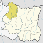
Solukhumbu District (Nepali: सोलुखुम्बु जिल्ला[solukʰumbu], Sherpa: ཤར་ཁུམ་བུ་རྫོང་།, Wylie: shar khum bu dzong) is one of 14 districts of Koshi Province of eastern Nepal. As the name suggests, it consists of the subregions Solu and Khumbu. The closest post office to Solukhumbu with a postal code assigned to it is the Sindhuli D.P.O., which has the postal code 56000.

Solududhkunda (earlier:Dudhkunda) is the only municipality of Solukhumbu District. Located in Province No. 1 of Nepal. The town of Salleri, which is located within the municipality is the headquarter of Solukhumbu District It was formed in 2014 by merging four VDCs: Salleri, Garma, Loding Tamakhani and Beni and was divided into 9 wards. Total area of the municipality had 254.3 square kilometres (98.2 sq mi) and population of municipality had 20,399 individuals living in 5,368 households.
Baku is a village development committee (VDC) in Solukhumbu District in the Sagarmatha Zone of north-eastern Nepal. Baku lies in the Himalaya, 59 km South of Mount Everest and is bordered by the valleys of Dudh Kosi River (West) and Hinku Drangka River (East). At the time of the 1991 Nepal census it had a population of 4159 people living in 777 individual households. At the time of the 2011 census, the population of the VDC Baku was 4844 inhabitants in 963 individual households.
Beni is a village development committee in Solukhumbu District in the Sagarmatha Zone of north-eastern Nepal. At the time of the 1991 Nepal census it had a population of 1927 people living in 352 individual households.
Bhakanje is a village development committee in Solukhumbu District in the Sagarmatha Zone of north-eastern Nepal. At the time of the 1991 Nepal census it had a population of 1188 people living in 226 individual households.
Tingla is a village development committee in Solukhumbu District in the Sagarmatha Zone of north-eastern Nepal. At the time of the 1991 Nepal census it had a population of 3,738 people living in 710 individual households.
Chaulakharka is a village development committee in Solukhumbu District in the Sagarmatha Zone of north-eastern Nepal. At the time of the 1991 Nepal census it had a population of 1839 people living in 372 individual households.

Chaurikharka is a village development committee in Solukhumbu District in the Sagarmatha Zone of northeastern Nepal. At the time of the 1991 Nepal census it had a population of 2422 people living in 502 individual households.
Deusa is a village development committee in Solukhumbu District in the Sagarmatha Zone of north-eastern Nepal. At the time of the 1991 Nepal census it had a population of 3835 people living in 747 individual households.
Gudel is a village development committee in Solukhumbu District in the Sagarmatha Zone of north-eastern Nepal. At the time of the 1991 Nepal census it had a population of 3,489 in 712 individual households. The people are part of the Kulung culture.
Jubing was a village development committee in Solukhumbu District in the Sagarmatha Zone of north-eastern Nepal. It was divided and merged into two new formed Rural municipality in 2017 when the old administrative structures were reconstructed. Ward no. 2, 3, 4 and 6 were incorporated with Dudhkoshi rural municipality and remaining all wards 1, 5, 7, 8 and 9 were incorporated with Khumbu Pasanglhamu rural municipality.
Kaku, Nepal is a village development committee in Solukhumbu District in the Sagarmatha Zone of north-eastern Nepal. At the time of the 1991 Nepal census it had a population of 3896 people living in 750 individual households.
Kangel is a village development committee in Solukhumbu District in the Sagarmatha Zone of north-eastern Nepal. At the time of the 1991 Nepal census it had a population of 2087 people living in 416 individual households.
Kerung is a village development committee in Solukhumbu District in the Sagarmatha Zone of north-eastern Nepal. At the time of the 2011 Nepal census, it had a population of 3,602 people living in 873 individual households.
Mukli is Headquarter of Thulung Dudhkoshi Rural Municipality, Ward No. 6 formerly a Village Development Committee in Solukhumbu District in the Sagarmatha Zone of north-eastern Nepal. At the time of the 1991 Nepal census it had a population of 2651 people living in 501 individual households.
Necha Batase was a village development committee in Solukhumbu District in the Sagarmatha Zone of north-eastern Nepal. At the time of the 1991 Nepal census it had a population of 3522 people living in 680 individual households.
Nele is a village development committee in Solukhumbu District in the Sagarmatha Zone of north-eastern Nepal. At the time of the 1991 Nepal census it had a population of 2021 people living in 364 individual households.
Panchan, Nepal is a village development committee in Solukhumbu District in the Sagarmatha Zone of north-eastern Nepal. At the time of the 1991 Nepal census it had a population of 1698 people living in 318 individual households.

Salyan, Solukhumbu was a village development committee in Solukhumbu District in the Sagarmatha Zone of north-eastern Nepal. At the time of the 1991 Nepal census it had a population of 5307 people living in 1034 individual households.
Nechasalyan is a rural municipality, or gaunpalika, located in Solukhumbu District, Province No. 1, Nepal. Solukhumbu has eight municipalities in all; one is an urban municipality and the other seven are rural municipalities.