
Inishowen is a peninsula in the north of County Donegal in Ireland. Inishowen is the largest peninsula on the island of Ireland.

Garrison Point Fort is a former artillery fort situated at the end of the Garrison Point peninsula at Sheerness on the Isle of Sheppey in Kent. Built in the 1860s in response to concerns about a possible French invasion, it was the last in a series of artillery batteries that had existed on the site since the mid-16th century. The fort's position enabled it to guard the strategic point where the River Medway meets the Thames. It is a rare example of a two-tiered casemated fort – one of only two of that era in the country – with a design that is otherwise similar to that of several of the other forts along the lower Thames. It remained operational until 1956 and is now used by the Sheerness Docks as a port installation.

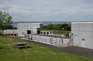
Fort Dunree is a coastal defence fortification located on the west side of the Inishowen peninsula, County Donegal, Ireland.

Lenan Head Fort, Lough Swilly, Inishowen, County Donegal was built in 1895, initially with three 9.2 inch Breech Loading (BL) guns. Following recommendations of the Owen Committee in 1905, it was refitted in 1911 with two newer Mark X 9.2 inch models. Both guns were operational during the First World War.

Buncrana is a town in County Donegal, Ireland. It is beside Lough Swilly on the Inishowen peninsula, 23 kilometres (14 mi) northwest of Derry and 43 kilometres (27 mi) north of Letterkenny. In the 2016 census, the population was 6,785 making it the second most populous town in County Donegal, after Letterkenny, and the largest in Inishowen.
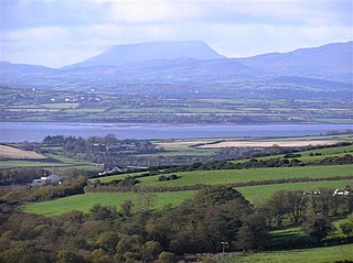
Lough Swilly in Ireland is a glacial fjord or sea inlet lying between the western side of the Inishowen Peninsula and the Fanad Peninsula, in County Donegal. Along with Carlingford Lough and Killary Harbour it is one of three glacial fjords in Ireland.
The Londonderry and Lough Swilly Railway Company was an Irish public transport and freight company that operated in parts of County Londonderry and County Donegal between 1853 and 2014. Incorporated in June 1853, it once operated 99 miles of railways. It began the transition to bus and road freight services in 1929. It closed its last railway line in July 1953 but continued to operate bus services under the name Lough Swilly Bus Company until April 2014, becoming the oldest railway company established in the Victorian era to continue trading as a commercial concern into the 21st century. Following a High Court petition by HM Revenue & Customs, the company went into liquidation and operated its final bus services on 19 April 2014.

Rathmullan is a small seaside village on the Fanad Peninsula in County Donegal, Ireland. It is situated on the western shore of Lough Swilly, 11 km (7 miles) north-east of Ramelton and 12 km (7.5 miles) east of Milford. Rathmullan serves as an important historical village as it was the scene of the Flight of the Earls in 1607, a major turning point in Irish history.

Downings or Downies is a Gaeltacht village and townland on the Rosguill peninsula in County Donegal, Ireland. The village is on the shores of Sheephaven Bay on the north coast of Ireland.

Urris is a valley to the west of the parish of Clonmany, in County Donegal, Ireland. It comprises the townlands of Crossconnell, Dunaff, Kinnea, Leenan, Letter, and Urrismenagh. It sits on the eastern side of Loch Swilly and it is bounded to the south-east by the Urris hills, and to the east by Binion hill. To the north, there is Rockstown bay and Tullagh peninsula. There are two entrances to Urris; the Gap of Mamore, and Crossconnell.

Dunree is a townland in north-west Inishowen, in County Donegal, Ireland. Part of the civil parish of Desertegney, the townland has an area of approximately 0.8 square kilometres (0.3 sq mi), and had a population of 33 people as of the 2011 census.

Burt is a parish in County Donegal, Ireland, on the main road between Letterkenny and Derry.
Buncrana railway station served Buncrana in County Donegal, Ireland.

Inch Island is in Inishowen, County Donegal, Ireland. The island is in Lough Swilly, a sea lough on the northern coast of Ireland.

The R246 road is a regional road in Ireland. It is a road mostly on the Fanad peninsula in County Donegal. The northernmost section of the road at Portsalon forms part of the Wild Atlantic Way.
Grey Point Fort is a battery located at Helen's Bay on the south side of Belfast Lough. It was part of the defences of Belfast.
The Antrim Artillery was a part-time reserve unit of Britain's Royal Artillery based in County Antrim, Northern Ireland, from 1853 to 1919. It numbered 1st on the order of precedence of the Militia Artillery. Volunteers from the unit served in the Second Boer War. During World War I it defended Belfast Lough and trained gunners for service overseas. Subsequent units continued the Antrim Artillery traditions.

Inch Fort, Lough Swilly, Inishowen, County Donegal was built between 1812 and 1813, during the Napoleonic Wars. It had positions for nine guns, six in an open battery and a further three in a blockhouse. Following the peace in 1815, the defences of Lough Swilly were neglected.

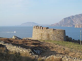
Macamish Fort is one of several Napoleonic batteries built along the shores of Lough Swilly in county Donegal, to defend the north west of Ireland. It was part of a scheme to fortify Lough Swilly and Lough Foyle against French Invasion during the Revolutionary and Napoleonic Wars and was completed between 1812 and 1813. It was built on a rock outcrop overlooking the lough. It comprises a Martello Tower mounting a single gun and battery mounting three guns. The fort was originally entered by a drawbridge.
Knockalla Fort is one of several Napoleonic batteries built along the shores of Lough Swilly in county Donegal, to defend the north west of Ireland. It was part of a scheme to fortify Lough Swilly and Lough Foyle against French Invasion during the Revolutionary and Napoleonic Wars and was completed between 1812 and 1813. On the other side of the Lough is Fort Dunree. The fort was built on the site of a temporary fortification first built in 1798.

