
Tennessee, is a landlocked state in the Southeastern region of the United States. It borders Kentucky to the north, Virginia to the northeast, North Carolina to the east, Georgia, Alabama, and Mississippi to the south, Arkansas to the southwest, and Missouri to the northwest. Tennessee is the 36th-largest by area and the 15th-most populous of the 50 states. According to the United States Census Bureau, the state's estimated population as of 2024 is 7.22 million.

Wilson County is a county in the U.S. state of Tennessee. It is in Middle Tennessee. As of the 2020 census, the population was 147,737. Its county seat is Lebanon. The largest city is Mt. Juliet. Wilson County is part of the Nashville-Davidson–Murfreesboro–Franklin, TN Metropolitan Statistical Area.

Middle Tennessee is one of the three Grand Divisions of Tennessee that composes roughly the central portion of the state. It is delineated according to state law as 41 of the state's 95 counties. Middle Tennessee contains the state's capital and largest city, Nashville, as well as Clarksville, the state's fifth largest city, and Murfreesboro, the state's sixth largest city and largest suburb of Nashville. The Nashville metropolitan area, located entirely within the region, is the most populous metropolitan area in the state, and the Clarksville metropolitan area is the state's sixth most populous. Middle Tennessee is both the largest, in terms of land area, and the most populous of the state's three Grand Divisions.

East Tennessee is one of the three Grand Divisions of Tennessee defined in state law. Geographically and socioculturally distinct, it comprises approximately the eastern third of the U.S. state of Tennessee. East Tennessee consists of 33 counties, 30 located within the Eastern Time Zone and three counties in the Central Time Zone, namely Bledsoe, Cumberland, and Marion. East Tennessee is entirely located within the Appalachian Mountains, although the landforms range from densely forested 6,000-foot (1,800 m) mountains to broad river valleys. The region contains the major cities of Knoxville and Chattanooga, Tennessee's third and fourth largest cities, respectively, and the Tri-Cities, the state's sixth largest population center.
The Highland Rim is a geographic term for the area in Tennessee, North Alabama, and Kentucky which surrounds the Central Basin. Geologically, the Central Basin is a dome. The Highland Rim is a cuesta surrounding the basin, and the border where the difference in elevation is sharply pronounced is an escarpment.
Fort Donelson National Battlefield preserves Fort Donelson and Fort Heiman, two sites of the American Civil War Forts Henry and Donelson Campaign, in which Union Army Brigadier General Ulysses S. Grant and Flag Officer Andrew Hull Foote captured three Confederate forts and opened two rivers, the Tennessee River and the Cumberland River, to control by the Union Navy. The commanders received national recognition for their victories in February 1862, as they were the first major Union successes of the war. The capture of Fort Donelson and its garrison by the Union led to the capture of Tennessee's capital and industrial center, Nashville, which remained in Union hands from February 25, 1862, until the end of the war, and gave the Union effective control over much of Tennessee. This struck a major blow to the Confederacy early in the war.
The Little Harpeth River is a 16.3-mile-long (26.2 km) tributary of the Harpeth River in Tennessee, just south of Nashville. Via the Harpeth, Cumberland, and Ohio rivers, it is part of the Mississippi River watershed.

The Red River, 100 miles (161 km) long, is a major stream of north-central Tennessee and south-central Kentucky, and a major tributary of the Cumberland River.

The tornado outbreak of April 15–16, 1998, also known as the 1998 Nashville tornado outbreak, was a two-day tornado outbreak that affected portions of the Midwestern United States, Mississippi and Tennessee Valleys on April 15 and April 16, 1998, with the worst of the outbreak taking place on the second day. On that day, 13 tornadoes swept through Middle Tennessee—two of them touching down in Nashville, causing significant damage to the downtown and East Nashville areas. Nashville became the first major city in nearly 20 years to have an F2 or stronger tornado make a direct hit in the downtown area.

Madison is a former settlement, now a suburban neighborhood of northeast Nashville, in the U.S. state of Tennessee. It is incorporated as part of the Metropolitan Government of Nashville and Davidson County.

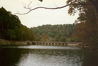
Edgar Evins State Park is a state park in DeKalb County, Tennessee, in the southeastern United States. The park consists of 6,300 acres (25 km2) along the shores of Center Hill Lake, an impoundment of the Caney Fork. The State of Tennessee leases the land from the U.S. Army Corps of Engineers.
This article pertains to the history of Nashville, the state capital of Tennessee. What is now Nashville was the center of civilization for the Mississippian culture around 1300. In 1779, Fort Nashborough was built here in 1779 by pioneers from North Carolina. In 1784 it was incorporated as a town by the North Carolina legislature. The Southwest Territory became the state of Tennessee in 1796 and Nashville became an incorporated city in 1806. In 1843 it became the state capital of Tennessee. In the Civil War Nashville was seized by Federal troops in 1862 and became a major Union military base. Confederate General J. B. Hood was decisively defeated in the Battle of Nashville in 1864. The city became the political, transportation, business and cultural center of the Middle Tennessee region. Besides the state government, it is best known for its educational, musical and religious establishments. In 1963 Nashville and Davidson County were consolidated under a single charter and are administered by a mayor and a council.

The Nashville metropolitan area is a metropolitan statistical area in north-central Tennessee. Its principal city is Nashville, the capital of and largest city in Tennessee. With a population of over 2 million, it is the most populous metropolitan area in Tennessee. It is also the largest metropolitan area in Tennessee in terms of land area.
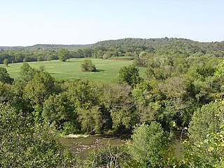
Standing Stone State Park is a state park in Overton County, Tennessee, in the southeastern United States. The park consists of 855 acres (3.46 km2) along the shoreline of the man-made 69-acre (0.28 km2) Standing Stone Lake. The 11,000-acre (45 km2) Standing Stone State Forest surrounds the park.
Mound Bottom is a prehistoric Native American complex in Cheatham County, Tennessee, located in the Southeastern United States. The complex, which consists of earthen platform and burial mounds, a 7-acre central plaza, and habitation areas, was occupied between approximately 1000 and 1300 AD, during the Mississippian period.
Old Hickory Boulevard is a historic road that encircles Nashville, Tennessee, lying entirely within Davidson County. Originally the road, aided by ferries, formed a nearly unbroken loop around the city. Today, it is interrupted by a lake and several rerouted sections, which consist of roughly 69 miles (111 km). Just over half the distance–36.2 miles (58.3 km)–is part of several Tennessee state highways, including SR 45, SR 171, SR 251, and SR 254. Unsigned concurrencies exist very briefly along US 31E, US 41/US 70S, and SR 100.
The U.S. state of Tennessee is geographically diverse, with varying terrains and several distinct physiographic regions. Its landforms range from the Blue Ridge Mountains in the eastern part of the state to flat and fertile plains along the Mississippi River. The state is geographically, legally, culturally, and economically divided into three Grand Divisions: East Tennessee, Middle Tennessee, and West Tennessee.
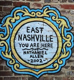
East Nashville is an area east of downtown Nashville in Tennessee across the Cumberland River. The area is mostly residential and mixed-use areas with businesses lining the main boulevards. The main thoroughfares are Gallatin Ave and Ellington Parkway, with smaller arteries interconnecting the neighborhoods. Some of these smaller arteries include Main Street, Shelby Avenue, Porter Road, Riverside Drive, Eastland Avenue, McFerrrin Avenue, and Woodland Street in no significant order. Ellington Parkway, which parallels Gallatin Ave and Main Street, bypasses I-24 and I-65 and connects Briley Parkway and downtown Nashville and many other secondary streets along the way. The Cumberland River confines most of the area with a semicircle design on the south, southwest and east. Since East Nashville has no defined boundaries on the west and north the exact perimeter is the cause of some debate. Some would say that Ellington Parkway creates a boundary on the west and northwest, while Cahal Avenue and Porter Road create the northern boundary, in the confines of zipcode 37206. Many would also state that with I-65 and I-24 as the western border and Briley Parkway as the northern boundary, this defines an area that constitutes Greater East Nashville. East Nashville is one of about 26 suburban neighborhoods in Nashville.

Richland Creek is a stream in the western part of Nashville, Tennessee, in Davidson County. It winds for 28 miles (45 km) through the Nashville suburbs of Belle Meade and Forest Hills and eventually flows into the Cumberland River near Rock Harbor Marina at the end of Robertson Avenue. This is one of at least five streams by the name of "Richland Creek" in various regions of Tennessee.