Related Research Articles

Death Valley is a desert valley in Eastern California, in the northern Mojave Desert, bordering the Great Basin Desert. It is thought to be the hottest place on Earth during summer.

California is a U.S. state on the western coast of North America. Covering an area of 163,696 sq mi (423,970 km2), California is among the most geographically diverse states. The Sierra Nevada, the fertile farmlands of the Central Valley, and the arid Mojave Desert of the south are some of the geographic features of this U.S. state. It is home to some of the world's most exceptional trees: the tallest, most massive, and oldest. It is also home to both the highest and lowest points in the 48 contiguous states.

The Amargosa River is an intermittent waterway, 185 miles (298 km) long, in southern Nevada and eastern California in the United States. The Amargosa River is one out of two rivers located in the California portion of the Mojave Desert with perenial flow. It drains a high desert region, the Amargosa Valley in the Amargosa Desert northwest of Las Vegas, into the Mojave Desert, and finally into Death Valley where it disappears into the ground aquifer. Except for a small portion of its route in the Amargosa Canyon in California and a small portion at Beatty, Nevada, the river flows above ground only after a rare rainstorm washes the region. A 26-mile (42 km) stretch of the river between Shoshone and Dumont Dunes is protected as a National Wild and Scenic River. At the south end of Tecopa Valley the Amargosa River Natural Area protects the habitat.

The Victor Valley is a valley in the Mojave Desert and subregion of the Inland Empire, in San Bernardino County in Southern California.
Searles Valley is a valley in the northern Mojave Desert of California, with the northern half in Inyo County and the southern half in San Bernardino County, California, United States.

The Dead Mountains are a mountain range in the southeastern Mojave Desert, in San Bernardino County, California. The range borders the tri-state intersection of Nevada, Arizona and California, and the Mohave Valley, with the Fort Mojave Indian Reservation bordering the range foothills on the east and northeast, in the three states.

Panamint City is a ghost town in the Panamint Range, near Death Valley, in Inyo County, California, US. It is also known by the official Board of Geographic Names as Panamint. Panamint was a boom town founded after silver and copper were found there in 1872. By 1874, the town had a population of about 2,000. Its main street was one mile (1.6 km) long. Panamint had its own newspaper, the Panamint News. Silver was the principal product mined in the area. The town is located about three miles northwest of Sentinel Peak. According to the National Geographic Names Database, NAD27 latitude and longitude for the locale are 36°07′06″N117°05′43″W, and the feature ID number is 1661185. The elevation of this location is identified as being 6,280 feet AMSL. The similar-sounding Panamint Springs, California, is located about 25.8 miles at 306.4 degrees off true north near Panamint Junction.

The Amargosa Desert is located in Nye County in western Nevada, United States, along the California–Nevada border, comprising the northeastern portion of the geographic Amargosa Valley, north of the Ash Meadows National Wildlife Refuge.
The Fremont Valley is a valley located in the western Mojave Desert of California.
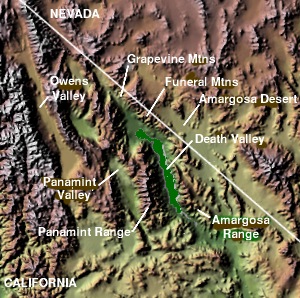
The Panamint Valley is a long basin located east of the Argus and Slate ranges, and west of the Panamint Range in the northeastern reach of the Mojave Desert, in eastern California, United States.

The Mojave Road, also known as Old Government Road, is a historic route and present day dirt road across what is now the Mojave National Preserve in the Mojave Desert in the United States. This rough road stretched 147 miles (237 km) from Beale's Crossing, to Fork of the Road location along the north bank of the Mojave River where the old Mojave Road split off from the route of the Old Spanish Trail/Mormon Road.

High Desert is a vernacular region with non-discrete boundaries covering areas of the western Mojave Desert in Southern California. The region encompasses various terrain with elevations generally between 2,000 and 4,000 ft above sea level, and is located just north of the San Gabriel, San Bernardino, and Little San Bernardino Mountains.
The Piper Mountain Wilderness is a federally designated wilderness area located in the White Mountains 20 miles (32 km) northeast of Big Pine, California in Inyo County, California.

The deserts of California are the distinct deserts that each have unique ecosystems and habitats. The deserts are home to a sociocultural and historical "Old West" collection of legends, districts, and communities, and they also form a popular tourism region of dramatic natural features and recreational development. Part of this region was even proposed to become a new county due to cultural, economic and geographic differences relative to the rest of the more urban region.
The Mesquite Mountains are a mountain range in eastern San Bernardino County, California, near the border with Nevada. They are north of Interstate 15 in California and southeast of Death Valley.
The Saline Range is a mountain range in Inyo County, California, within Death Valley National Park.
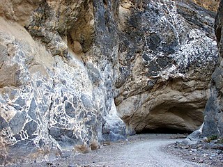
Titus Canyon is a deep, narrow gorge cut into the steep face of the Grapevine Mountains of the Mojave Desert, within Death Valley National Park in southeastern California and southwestern Nevada. The canyon features limestone rock formations, petroglyphs, and native plants and wildlife.
Bell Mountain is an unincorporated community in the Victor Valley region of the Mojave Desert, within San Bernardino County, southern California.

Bennett-Arcane Long Camp was a 1849er camp set up in December 1849 in Death Valley as they traveled to the California Gold Rush. They were emigrants crossing the harsh desert to get to California. The camp was located just west of valley's Badwater Basin in present-day Death Valley National Park. Badwater Basin is lowest point in North America and the United States, at a depth of 282 ft (86 m) below sea level. The Bennett-Arcane party became known as the Death Valley '49ers. The Death Valley '49ers were pioneers from the Eastern United States travelling west to prospect in the Sutter's Fort area of the Central Valley and Sierra Nevada in California. The wagon train crossed Utah across the Great Basin Desert in Nevada. They made a wrong turn on got trapped in Death Valley. After exiting they crossed the Mojave Desert into Southern California. Still wanting to go to the California Gold Country, the group used the southern Desert part of the Old Spanish Trail, after hearing about the death of the Donner Party. Allegedly, the Bennett-Arcane group coined the name Death Valley.

The South Lahonton is a hydrologic region defined by the State of California that encompasses several interior basins east of the Sierra Nevada and the Transverse Ranges, with an area of 17 million acres (69,000 km2). It covers the western portion of the Mojave Desert and a southwestern portion of the Great Basin desert, and extends into the forests of the southeastern Sierra Nevada and the montane chaparral and woodlands of the northeastern Transverse ranges. The ecoregion has an arid to semi-arid climate, with average annual rainfall of 7.9 inches (200 mm).
References
- ↑ U.S. Geological Survey Geographic Names Information System: Nelson Range (California)
- ↑ Goldman, Edward A. (1935). "Edward William Nelson - Naturalist, 1855-1934" (PDF). Auk. 52 (2): 135–148. doi:10.2307/4077197. JSTOR 4077197.