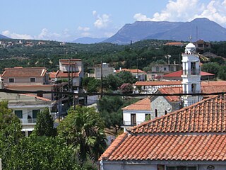
Neochori (Greek: Νεοχώρι) is a village on the island of Chios, Greece. It is part of the municipality Agios Minas, and located approximately 9 kilometers from the capital of the island, Chios (town), also known locally as Chora. There are medieval manuscripts that refer to the village but no sign of the Middle Ages was preserved. The inhabitants are mainly farmers. The main church is devoted to Virgin Mary and it is an example of the local architecture of the 19th century.
Greek is an independent branch of the Indo-European family of languages, native to Greece, Cyprus and other parts of the Eastern Mediterranean and the Black Sea. It has the longest documented history of any living Indo-European language, spanning more than 3000 years of written records. Its writing system has been the Greek alphabet for the major part of its history; other systems, such as Linear B and the Cypriot syllabary, were used previously. The alphabet arose from the Phoenician script and was in turn the basis of the Latin, Cyrillic, Armenian, Coptic, Gothic, and many other writing systems.
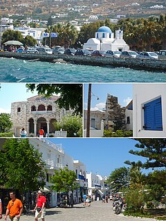
Chios is the fifth largest of the Greek islands, situated in the Aegean Sea, 7 kilometres (4.3 mi) off the Anatolian coast. The island is separated from Turkey by the Chios Strait. Chios is notable for its exports of mastic gum and its nickname is the Mastic Island. Tourist attractions include its medieval villages and the 11th-century monastery of Nea Moni, a UNESCO World Heritage Site.
Greece, officially the Hellenic Republic, also known as Hellas, is a country located in Southern and Southeast Europe, with a population of approximately 11 million as of 2016. Athens is the nation's capital and largest city, followed by Thessaloniki.
The haven of Neochori is beach of Agia Fotia. Near the beach are hotels, rooms and studios to let, taverns, and cafes. The Monastery of Agios Minas overlooks the village from the hill nearby. This monastery was built during 1572 -1595 by the Reverend Father Neofitos Koumanos and his son, Father Menas, at the time of Patriarch Jeremiah II. Initially it housed monks, but in 1932 it was converted into a nunnery. During the Turkish occupation, it maintained a school and a noteworthy library. This monastery is famous in world history for the massacre of 1822 when crowds of Chians were killed by the Turks or burned inside the chapel and in the courtyard of the monastery. Today, there is still evidence of the victims with the bloodstained stone floors of the chapel. The bones of many of the victims are kept in the Mausoleum of the 40 Martyrs in the courtyard of the monastery. There were 35 nuns in the monastery who were kept busy with hagiography, crafts and the sewing of ecclesiastical garments. Today, only 11 nuns live in the Monastery.
A geographic coordinate system is a coordinate system that enables every location on Earth to be specified by a set of numbers, letters or symbols. The coordinates are often chosen such that one of the numbers represents a vertical position and two or three of the numbers represent a horizontal position; alternatively, a geographic position may be expressed in a combined three-dimensional Cartesian vector. A common choice of coordinates is latitude, longitude and elevation. To specify a location on a plane requires a map projection.
This page is based on this Wikipedia article Text is available under the CC BY-SA 4.0 license; additional terms may apply. Images, videos and audio are available under their respective licenses.
Related Research Articles
Salamis, is the largest Greek island in the Saronic Gulf, about 1 nautical mile (2 km) off-coast from Piraeus and about 16 kilometres west of central Athens. The chief city, Salamina, lies in the west-facing core of the crescent on Salamis Bay, which opens into the Saronic Gulf. On the Eastern side of the island is its main port, Paloukia, in size second in Greece only to Piraeus, the port of Athens.
Paros is a Greek island in the central Aegean Sea. One of the Cyclades island group, it lies to the west of Naxos, from which it is separated by a channel about 8 kilometres wide. It lies approximately 150 km south-east of Piraeus. The Municipality of Paros includes numerous uninhabited offshore islets totaling 196.308 square kilometres (75.795 sq mi) of land. Its nearest neighbor is the municipality of Antiparos, which lies to its southwest. In ancient Greece, the city-state of Paros was located on the island.
Icaria, also spelled Ikaria, is a Greek island in the Aegean Sea, 10 nautical miles (19 km) southwest of Samos. According to tradition, it derives its name from Icarus, the son of Daedalus in Greek mythology, who was believed to have fallen into the sea nearby.
Kastro-Kyllini is a former municipality in Elis, West Greece, Greece. Since the 2011 local government reform it is part of the municipality Andravida-Kyllini, of which it is a municipal unit. The municipal unit has an area of 49.322 km2. The population was 3,622 in 2011. The municipality Kastro-Kyllini was created in 1999 as part of the Kapodistrias reform from the formerly independent communities Kyllini, Kato Panagia, Kastro and Neochori, that became municipal districts. After the 2011 Kallikratis reform, these municipal districts became (dependent) communities. Its seat of administration was the small port town of Kyllini.
Skiathos is a small Greek island in the northwest Aegean Sea. Skiathos is the westernmost island in the Northern Sporades group, east of the Pelion peninsula in Magnesia on the mainland, and west of the island of Skopelos.
Agios Isidoros is a village in the municipal unit of Plomari, Lesbos Island, Greece. It is located just one kilometer outside the town of Plomari, South Lesbos. It has a pebbled beach which is one of the longest in Lesbos and voted as the 7th best beach in Greece due to the safety provided, the clean water and care for the environment.
Agios Minas is a former municipality on the island of Chios, North Aegean, Greece. Since the 2011 local government reform it is part of the municipality Chios, of which it is a municipal unit. It is located on the central east coast of the island, just south of Chios (town). Its land area is 13.049 km². Its population was 3,271 at the 2011 census. The seat of the municipality was in Thymiana. Its next largest town is Neochori (587).
Mastichochoria is a former municipality on the island of Chios, North Aegean, Greece. Since the 2011 local government reform it is part of the municipality Chios, of which it is a municipal unit. It is located in the southwestern and extreme southern part of the island. It is the largest municipal unit in land area on Chios at 211.687 km2. Its population was 3,672 at the 2001 census. The seat of the municipality was Pyrgi. The next largest villages are Kalamotí (569), Armólia (442), Mestá (337), and Lithío (397). The small coastal village of Emporeios (47) boasts an archaeological site.
The North Aegean islands are a number of disconnected islands in the north Aegean Sea, also known as the Northeast Aegean islands, belonging to Greece and Turkey. The islands do not form a physical chain or group, but are frequently grouped together for tourist or administrative purposes. To the south are the Dodecanese islands; and to the west are the Cyclades and Sporades islands.
Palaiochori is a village in Chalkidiki, Greece, part of the municipality Arnaia. It is situated between the villages Neochori, Megali Panagia and Arnaia.
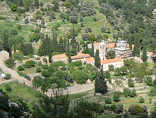
Nea Moni is an 11th-century monastery on the island of Chios that has been recognized as a UNESCO World Heritage Site. It is located on the Provateio Oros Mt. in the island's interior, about 15 km from Chios town. It is well known for its mosaics, which, together with those at Daphni and Hosios Loukas, are among the finest examples of "Macedonian Renaissance" art in Greece.
Elata is a Greek village on the island of Chios. The village is situated on hilly terrain and has a population of several hundred.
Avramiou is a village in Messenia, southern Greece. It was built before 1816; it had 32 families then. During the Turkish occupation, it was a village of Koroni province, and became a village of Messini province and capital of Leukothea Municipality in 1835. In August 1840, Avramiou became a village of Aristomenis Municipality; it was almost destroyed by earthquakes in 1846. The primary school of Avramiou was founded in 1860. Ten years after, Avramiou became the capital of Aristomeni Municipality. Today, it is a community of the municipality Messini. The community contains the villages Drakoneri, Agios Avgoustinos and Avramiou. In 2011, the population for Avramiou village was 334, and 466 for the community.
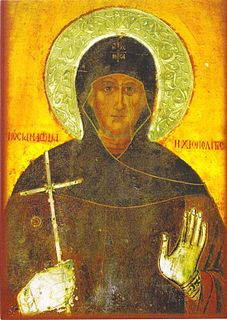
Saint Matrona of Chios was born during the 15th century in the village of Volissos on the island of Chios, Greece. This is the same village in which St. Markella was martyred in 1462. The Church celebrates her memory on October 20, and the finding of her head on July 15.
Kontopouli is a village and a community in the municipal unit of Moudros in the northeastern part of the island of Lemnos, Greece. In 2011 its population was 623 for the village and 634 for the community, which includes the small villages Agios Alexandros and Agios Theodoros. Its total area is 37.04 km². Kontopouli is 1 km northwest of Kalliopi, 3 km east of Repanidi and 8 km northeast of Moudros.
Plaka is a village in the northeasternmost part of the island of Lemnos, Greece. It is part of the municipal unit of Moudros. In 2011 its population was 310 people. The island of Imbros in Turkey is just 24 km northeast. It is situated somewhere in the middle of the straight line between Troy and Mount Athos. Some believe that it is the Ermaion lepas of the ancient, through which was transmitted with fire the news of the sack of Troy to Argos and Mycenae. Although the edge has an elevation of just 70 m, the cape comes deep into the sea and it is easily seen from those two areas. Therefore, in 1912 a 30 m high rotating lighthouse was built with a luminous range of 20 nautical miles (37 km).
Karfas, is a small town on the island of Chios, Greece. Located 7 kilometers south of Chios (town), Karfas is among the most popular destinations on the Island, attracting high amounts of tourism due to its cosmopolitan beaches, studios, residences, clubs, restaurants, and general nightlife. Karfas is approximately 3 kilometers from Chios Island National Airport.
Kallimasia is a town of Chios, built 13 kilometers south of the capital of the island.
The Christianization of the Olympus region began relatively early. While the episcopal seats from Byzantine times only remaining ruins, inhabited and used monasteries and churches are still present at this time at Olympus. Some of the monasteries are a stauropegion, ie they are directly subordinate to the Patriarch of Constantinople (Istanbul), others belong to a diocese. The number of churches and chapels around Mount Olympus is hard to overlook. That is why only the monasteries and most important churches are mentioned.