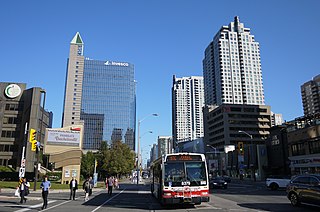
North York City Centre is a central business district in Toronto, Ontario, Canada in the district of North York. It is centred along Yonge Street, between Sheppard and Finch Avenues around the Mel Lastman Square civic square. The district is a high-density district of condominium and office towers around the wide six lanes of Yonge Street.

Henry Farm is a neighbourhood in the City of Toronto, Ontario, Canada. It is located in the north central part of the city within the former city of North York.
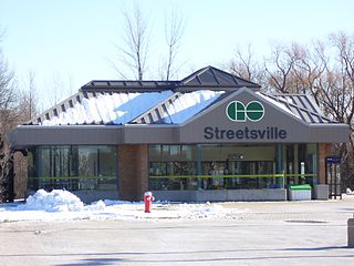
Streetsville GO Station is a GO Transit railway station on the Milton line in the Greater Toronto Area, Ontario, Canada. It is located in the community of Streetsville in Mississauga, basically resembling the atmosphere of a heritage site in a modern city. It is situated at 45 Thomas Street, near Britannia Road and Mississauga Road.
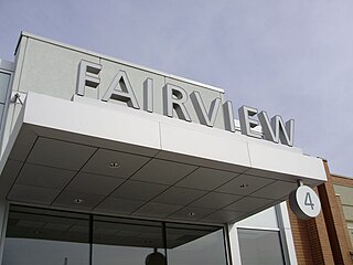
Fairview Mall is a large shopping centre in Toronto, Ontario, Canada of about 80,000 m2 (860,000 sq ft). Opened in 1970, the centre has over 180 stores, offices and a cinema complex. It is located several kilometres north-east of downtown, at the northeast corner of Don Mills Road and Sheppard Avenue East in the former borough of North York.
Parkway Forest is a neighbourhood in Toronto, Ontario, Canada. It is located in the north of the city, in the former City of North York, which was merged with five other municipalities and a regional government to form the new "City of Toronto" in 1998.

Scarborough—Rouge River was a federal electoral district in Ontario, Canada, that has been represented in the House of Commons of Canada between 1988 and 2015. However, as of the Fall 2015 federal election, part of this riding has been combined with the south-western part of the old riding Pickering—Scarborough East.
Pickering—Scarborough East was a federal electoral district in Ontario, Canada, that had been represented in the House of Commons of Canada from 2004 to 2015.

The North York Civic Centre is a building in Toronto, Ontario, Canada that once served as the city hall for the former City of North York.

The Government of Canada Building, also known as the Joseph Shepard Federal Building, is a Government of Canada office complex at 4900 Yonge Street in North York. Built in 1977 to service residents of the former Metropolitan Toronto boroughs of North York and Etobicoke, it houses a branch of the Passport Office in addition to other federal departments. The building was designed by Macy DuBois and is a Classified Federal Heritage Building.

Dempsey Store was a hardware store built in 1860 at the northwest corner of Yonge Street and Sheppard Avenue, in North York, Toronto, Ontario, Canada. The historic store was moved and restored as a historic site further north at 250 Beecroft Avenue in 1996. The site in Dempsey Park is maintained by the Toronto Parks, Forestry and Recreation Division and the North York Historical Society.

Humbermede, often called Emery, is a neighbourhood of Toronto, Ontario, Canada. Humbermede, like many of the "Humber" neighbourhoods in the city, gets its name from the Humber River. It is bounded on the west by the Humber River, on the north by Finch Avenue West, on the east by the Highway 400 and on the south by Sheppard Avenue West.

Lansing is a neighbourhood in the North York district of Toronto, Ontario, Canada. It is defined by the City of Toronto as Lansing-Westgate. Lansing is now bordered by Yonge Street to the east, Highway 401 to the south, Bathurst Street to the west and Burnett Avenue to the north.

Pleasant View is a neighbourhood in the city of Toronto, Ontario, Canada that is located in the district of North York at the northern end of the city. It is bordered by Victoria Park to the East, Sheppard Avenue to the South, Highway 404 to the west and the Finch hydro corridor to the north. The neighbourhood is home to several high-rise apartment and condominium buildings, such as The Clippers.

Don Valley Village is a neighbourhood in the city of Toronto, Ontario, Canada. It is located in the former suburb of North York. It is located north of Highway 401, and is bounded by Sheppard Avenue to the south, Leslie Street to the west, Finch Avenue to the north and Highway 404 to the east. Like the nearby Don River Valley, the neighbourhood has hill and dale topography.

CPR Toronto Yard is a facility located in northeast Toronto, Ontario, Canada, often incorrectly referred to as Agincourt Yard because it is located in Agincourt, a neighbourhood of Toronto.

Concord Park Place is a 45-acre (18 ha) multi-tower condominium complex under construction in Toronto, Ontario, Canada, between Sheppard Avenue, Leslie Street, Highway 401, and Bessarion Road. The development creates a south extension of the Bayview Village neighbourhood of North York.
Lieutenant-Colonel George Taylor Denison III Armoury, commonly known as Denison Armoury, is a Canadian Forces facility located at 1 Yukon Lane in Toronto, Ontario, Canada. It is in the northeastern corner of Downsview Airport just west of the W.R. Allen Expressway on Sheppard Avenue West. The Armoury is the headquarters of 4th Canadian Division, Joint Task Force Central, and the 32 Canadian Brigade Group. It is also home to several units of the brigade.

Battlefield House near King Street East and Centennial Parkway in Stoney Creek, Hamilton, Ontario, Canada is a living history museum and site of the historic Battle of Stoney Creek on June 6, 1813, which was fought during the War of 1812. It was built in 1796. The house and 15.5 acres (6.3 ha) of parkland, were the property of the Women's Wentworth Historical Society, (1899-1962), and given by this society to the Niagara Parks Commission on January 19, 1962. The park was designated a National Historic Site of Canada in 1960.
Richmond-Adelaide Centre is a cluster of office buildings in Toronto, Ontario, Canada, located in the financial district. It is bounded by Richmond Street West to the north, Sheppard Street to the east, Adelaide Street West to the south, and finally York Street as its western boundary. The complex is owned and operated by global real estate investor, developer and owner Oxford Properties Group.


