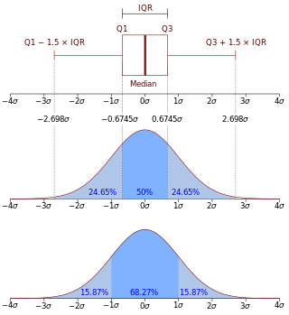
In descriptive statistics, the interquartile range (IQR) is a measure of statistical dispersion, which is the spread of the data. The IQR may also be called the midspread, middle 50%, fourth spread, or H‑spread. It is defined as the difference between the 75th and 25th percentiles of the data. To calculate the IQR, the data set is divided into quartiles, or four rank-ordered even parts via linear interpolation. These quartiles are denoted by Q1 (also called the lower quartile), Q2 (the median), and Q3 (also called the upper quartile). The lower quartile corresponds with the 25th percentile and the upper quartile corresponds with the 75th percentile, so IQR = Q3 − Q1.
In formal language theory and computer programming, string concatenation is the operation of joining character strings end-to-end. For example, the concatenation of "snow" and "ball" is "snowball". In certain formalizations of concatenation theory, also called string theory, string concatenation is a primitive notion.
CDF is a three-letter acronym that may refer to:
Common Data Format (CDF) is a library and toolkit that was developed by the National Space Science Data Center (NSSDC) at NASA started in 1985. The software is an interface for the storage and manipulation of multi-dimensional data sets.
In computer programming, operators are constructs defined within programming languages which behave generally like functions, but which differ syntactically or semantically.
A concatenative programming language is a point-free computer programming language in which all expressions denote functions, and the juxtaposition of expressions denotes function composition. Concatenative programming replaces function application, which is common in other programming styles, with function composition as the default way to build subroutines.
OPeNDAP is an endeavor focused on enhancing the retrieval of remote, structured data through a Web-based architecture and a discipline-neutral Data Access Protocol (DAP).
GRIB is a concise data format commonly used in meteorology to store historical and forecast weather data. It is standardized by the World Meteorological Organization's Commission for Basic Systems, known under number GRIB FM 92-IX, described in WMO Manual on Codes No.306. Currently there are three versions of GRIB. Version 0 was used to a limited extent by projects such as TOGA, and is no longer in operational use. The first edition is used operationally worldwide by most meteorological centers, for Numerical Weather Prediction output (NWP). A newer generation has been introduced, known as GRIB second edition, and data is slowly changing over to this format. Some of the second-generation GRIB is used for derived products distributed in the Eumetcast of Meteosat Second Generation. Another example is the NAM model.
TNT Sports Chile is a privately owned sports pay TV channel of Chile. It launched in 2003 and it was controlled by the Asociación Nacional de Fútbol Profesional, the Chilean football league after of the authorization of sale by the FNE in Chile. Now is operated by Warner Bros. Discovery International. Originally called CDF, it was renamed on January 17, 2021.
Tacit programming, also called point-free style, is a programming paradigm in which function definitions do not identify the arguments on which they operate. Instead the definitions merely compose other functions, among which are combinators that manipulate the arguments. Tacit programming is of theoretical interest, because the strict use of composition results in programs that are well adapted for equational reasoning. It is also the natural style of certain programming languages, including APL and its derivatives, and concatenative languages such as Forth. The lack of argument naming gives point-free style a reputation of being unnecessarily obscure, hence the epithet "pointless style".
Smart messaging is a proprietary service developed by Nokia used for the sending and receiving of various digital media via SMS.
This comparison of programming languages (strings) compares the features of string data structures or text-string processing for over 52 various computer programming languages.
The root mean square deviation (RMSD) or root mean square error (RMSE) is either one of two closely related and frequently used measures of the differences between true or predicted values on the one hand and observed values or an estimator on the other. The deviation is typically simply a differences of scalars; it can also be generalized to the vector lengths of a displacement, as in the bioinformatics concept of root mean square deviation of atomic positions.
The World Ocean Atlas (WOA) is a data product of the Ocean Climate Laboratory of the National Centers for Environmental Information (U.S.). The WOA consists of a climatology of fields of in situ ocean properties for the World Ocean. It was first produced in 1994, with later editions at roughly four year intervals in 1998, 2001, 2005, 2009, 2013, 2018, and 2023.
Language Integrated Query is a Microsoft .NET Framework component that adds native data querying capabilities to .NET languages, originally released as a major part of .NET Framework 3.5 in 2007.
NetCDF is a set of software libraries and self-describing, machine-independent data formats that support the creation, access, and sharing of array-oriented scientific data. The project homepage is hosted by the Unidata program at the University Corporation for Atmospheric Research (UCAR). They are also the chief source of netCDF software, standards development, updates, etc. The format is an open standard. NetCDF Classic and 64-bit Offset Format are an international standard of the Open Geospatial Consortium.

Voreen is an open-source volume visualization library and development platform. Through the use of GPU-based volume rendering techniques it allows high frame rates on standard graphics hardware to support interactive volume exploration.
The Climate and Forecast (CF) metadata conventions are conventions for the description of Earth sciences data, intended to promote the processing and sharing of data files. The metadata defined by the CF conventions are generally included in the same file as the data, thus making the file "self-describing". The conventions provide a definitive description of what the data values found in each netCDF variable represent, and of the spatial and temporal properties of the data, including information about grids, such as grid cell bounds and cell averaging methods. This enables users of files from different sources to decide which variables are comparable, and is a basis for building software applications with powerful data extraction, grid remapping, data analysis, and data visualization capabilities.
CDO is a command line computer software suite providing more than 600 operators for manipulating and analysing climate data.