U6 is a Berlin U-Bahn line, 19.9 km (12.4 mi) long line with 29 stations. It runs in a north-south direction from the Berlin locality of Tegel in the north via Friedrichstraße to Mariendorf, a locality in the southern part of the city. It is a so-called large profile ("Großprofil") line.

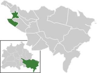
Britz is a German locality (Ortsteil) within the Berlin borough (Bezirk) of Neukölln.

Chris Gueffroy was the last person to be shot and the second-last to die in an escape attempt while trying to escape from East Berlin to West Berlin across the Berlin Wall.

The underground station Hallesches Tor is part of the Berlin U-Bahn network at the intersection of the east-west bound U1/U3 and the north-south bound U6 in the central Kreuzberg quarter. It is named after historic Hallsches Tor of the Berlin Customs Wall, erected in the 18th century.

Gneisenaustraße is a station on the U7 U-Bahn in Berlin, Germany. The station was opened in 1924 and created by Alfred Grenander. 1945 it was closed for a few months, 1967/68 the platform was elongated. Due to this the station has lost its appearance as it was when Grenander has planned it.

Ullsteinstraße is a Berlin U-Bahn station located on the U 6. The station was designed by R. G. Rümmler and opened in 1966.

Berlin Hermannstraße is a railway station in the Neukölln district of Berlin. It is served by the S-Bahn lines S 41, S 42, S 45, S 46 and S 47 and the U-Bahn line U 8, of which it is the southern terminus. It was formerly also possible to transfer there to the Neukölln-Mittenwalde railway line, which is now only used for goods traffic.
The Greater Berlin Act, in full the Law Regarding the Creation of the New Municipality of Berlin, was a law passed by the Prussian government in 1920 that greatly expanded the size of the German capital of Berlin.
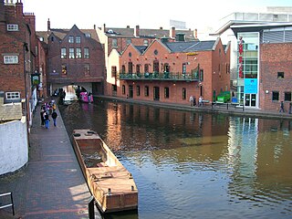
Gas Street Basin is a canal basin in the centre of Birmingham, England, where the Worcester and Birmingham Canal meets the BCN Main Line. It is located on Gas Street, off Broad Street, and between the Mailbox and Brindleyplace canal-side developments.
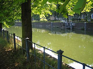
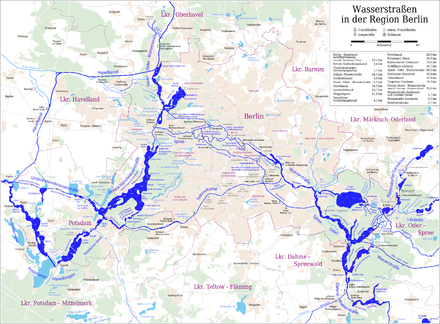
The Landwehr Canal, or Landwehrkanal in German, is a 10.7-kilometre (6.6 mi) long canal parallel to the Spree river in Berlin, Germany, built between 1845 and 1850 according to plans by Peter Joseph Lenné. It connects the upper part of the Spree at the Osthafen in Friedrichshain with its lower part in Charlottenburg, flowing through Kreuzberg and Tiergarten.

The Schloss Britz is the former manor-house of the historical Rittergut and village Britz, now a district of Berlin-Neukölln. Today it is the headquarters of the cultural organization Kulturstiftung Schloss Britz and includes authentic reconstructed rooms from around 1880. The house is a museum demonstrating interiors of the Gründerzeit era. The manorial park is also well preserved with its mature trees and its 1890s system of trails. In 1997 the park was honored with the German Gustav Meyer Prize for the accuracy and historic authenticity of the reconstruction.
Buckow is a locality (Ortsteil) within the Berlin borough (Bezirk) of Neukölln.

Rudow (help·info) is a locality (Ortsteil) within the Berlin borough (Bezirk) of Neukölln.
Baumschulenweg is a German locality (Ortsteil) within the Berlin borough (Bezirk) of Treptow-Köpenick. Until 2001 it was part of the former borough of Treptow. Its name means road (weg) of the plant nurseries (Baumschulen). It was named after the Späth nursery.

The Griebnitz Canal, formerly known as the Prinz-Friedrich-Leopold-Kanal, is a canal in the western suburbs of Berlin, the capital city of Germany. It consists of a chain of small lakes: the Stölpchensee, Pohlesee, and Kleiner Wannsee, together with artificial channels linking them together.
The Teltow Canal, also known as the Teltowkanal (help·info) in German, is a canal to the south of Berlin, the capital city of Germany. The canal lies in both the states of Berlin and Brandenburg, and at points forms the boundary between the two. It takes its name from the Brandeburgian region of Teltow and town of Teltow which lie on its course. The canal was constructed between 1900 and 1906 when it was opened by Wilhelm II.

The Britz Canal, or Britzer Verbindungskanal in German, is a 3.4-kilometre (2.1 mi) long canal in Berlin, Germany. The canal was built between 1900 and 1906, and was previously known as the Britz Branch Canal or Britzer Zweigkanal.

The Westhafen Canal, or Westhafenkanal in German, is a canal in Berlin, Germany. The 3.1-kilometre (1.9 mi) long canal connects with the Westhafen inland port and the Berlin-Spandau Ship Canal at its eastern end, and with the River Spree in Charlottenburg at its western end. It has no locks.

The Charlottenburg Canal, or Charlottenburger Verbindungskanal in German, is a canal in Berlin, Germany.

Blub, short for Berliner Luft- und Badeparadies, was a water park in the Britz area of Neukölln district in Berlin, Germany. First opened in 1985, it was shut down in 2002 following health concerns, and the 35000 square meter site fell into disrepair. In 2016, the buildings on the site were severely damaged by fire. The site is planned to be redeveloped.