Neve Dan

Last updated

Neve Dan (Hebrew : נווה דן), also Shikun Dan (Hebrew : שיכון דן), is a residential neighborhood of Tel Aviv, Israel. It is located in the northeastern part of the city. It is named after the tribe of Dan, whose first living place was here.

Hebrew language Semitic language native to Israel

Hebrew is a Northwest Semitic language native to Israel; the modern version of which is spoken by over 9 million people worldwide. Historically, it is regarded as the language of the Israelites and their ancestors, although the language was not referred to by the name Hebrew in the Tanakh. The earliest examples of written Paleo-Hebrew date from the 10th century BCE. Hebrew belongs to the West Semitic branch of the Afroasiatic language family. Hebrew is the only living Canaanite language left, and the only truly successful example of a revived dead language.

Tel Aviv City in Israel

Tel Aviv is the second most populous city in Israel—after Jerusalem—and the most populous city in the conurbation of Gush Dan, Israel's largest metropolitan area. Located on the country's Mediterranean coastline and with a population of 443,939, it is the economic and technological center of the country.

Israel country in the Middle East

Israel, officially the State of Israel, is a country in Western Asia, located on the southeastern shore of the Mediterranean Sea and the northern shore of the Red Sea. It has land borders with Lebanon to the north, Syria to the northeast, Jordan on the east, the Palestinian territories of the West Bank and Gaza Strip to the east and west, respectively, and Egypt to the southwest. The country contains geographically diverse features within its relatively small area. Israel's economic and technological center is Tel Aviv, while its seat of government and proclaimed capital is Jerusalem, although the state's sovereignty over Jerusalem has only partial recognition.

History

Neve Dan was founded as Yad HaMa'avir (Hebrew : יד המעביר). Construction started in 1947 [1] and completed in 1950. The neighborhood was built to house the employees of the Dan Bus Company.[ citation needed ]

Dan Bus Company

Dan Bus Company is an Israeli bus company based in Tel Aviv. It operates local bus service in the Tel Aviv Metropolitan Area as well as some intercity bus services between the Gush Dan area and nearby regions.

In 1953 Yad HaMa'avir was incorporated into Tel Aviv. [2] In 1957 the neighborhood's housing, previously owned by the Israeli government, was handed over to the residents.

Streets in Neve Dan SHykvn dn Shikun Dan neighborhood.jpg
Streets in Neve Dan

Related Research Articles

Gush Dan Metropolitan area in Israel

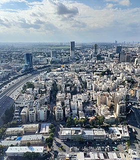
Gush Dan is a conurbation in Israel, located along the country's Mediterranean coastline. It includes areas from both the Tel Aviv and the Central Districts, or sometimes the whole Metropolitan Area of Tel Aviv, which includes a small part of the Southern District as well. The Gush Dan bloc is the largest conurbation and metropolitan area in Israel, with the metropolitan area having an estimated population of 3,954,570 residents, 95% of whom are Israeli Jews. Despite making up less than 8% of Israel's total land area, it houses about 45% of the country's total population.

Ramat Aviv Neighborhood of Tel Aviv in Tel Aviv, Israel

Ramat Aviv Alef or Ramat Aviv HaYeruka, and originally plainly Ramat Aviv, is a neighborhood in northwest Tel Aviv, Israel.

Tel Aviv central bus station

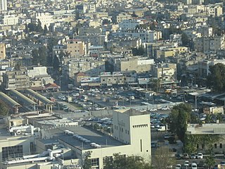
Tel Aviv central bus station, also known as the new central bus station, is the main bus station of Tel Aviv, Israel. Located in the south of the city, it was opened on August 17, 1993. It is the 2nd largest bus station in the world. The station in Tel Aviv covers 230,000 m2 and a total area of 44,000 m2.

Herzliya Hebrew Gymnasium gymnasium

The Herzliya Hebrew Gymnasium, originally known as HaGymnasia HaIvrit is a historic high school in Tel Aviv, Israel.

Kerem HaTeimanim "Yemenite Street" in Tel Aviv

Kerem HaTeimanim is a neighborhood in the center of Tel Aviv, Israel. The neighborhood is adjacent to the Carmel Market. The name means Vineyard of the Yemenites, and the area is also known as the Yemenites Quarter.

Kiryat Eliezer Stadium football stadium

The Haifa Municipal Stadium, more commonly known as Kiryat Eliezer, was a multi-use stadium in the Kiryat Eliezer neighborhood of Haifa, Israel. It was mostly used for football matches and as the home stadium of Maccabi Haifa and Hapoel Haifa. It was replaced by the new Sammy Ofer Stadium at the southern entrance to the city in 2014.

Neve Shaanan, Tel Aviv

Neve Sha'anan is a neighborhood in Tel Aviv, Israel, founded in 1923.

Neve Tzedek Quarter of Tel Aviv.

Neve Tzedek is a neighborhood located in southwestern Tel Aviv, Israel. It was the first Jewish neighborhood to be built outside the old city of the ancient port of Jaffa. Originally a Mizrahi Jewish and Yemenite Jewish neighbourhood, for years, the neighborhood prospered as Tel Aviv, the first modern Hebrew city, grew up around it. Years of neglect and disrepair followed, but since the early 1980s, Neve Tzedek has become one of Tel Aviv's latest fashionable and expensive districts, with a village-like atmosphere. Literally, Neve Tzedek means Abode of Justice, but it is also one of the names for God.

This list of the neighborhoods of Tel Aviv, is arranged geographically from north to south, then from west to east.

Mateh Yehuda Regional Council Place in Israel

Mateh Yehuda Regional Council is a regional council in the Jerusalem District of Israel. In 2008 it was home to 36,200 people.

Hatikva Quarter Tel Aviv neighborhood

Hatikva Quarter is a working class neighbourhood in southeastern Tel Aviv, Israel.

HaKirya area in central Tel Aviv, Israel

HaKirya, or The Kirya, is an area in central Tel Aviv, consisting of the Camp Rabin military base north of Kaplan Street, and a civilian area south of it.

Yad Eliyahu Neighborhood in Tel Aviv

Yad Eliyahu is a neighborhood in east Tel Aviv, Israel.

Yehuda Hamaccabi is a neighborhood in the north-central part of Tel Aviv. It is named after Judas Maccabeus, one of the great warriors in Jewish history, who led the Maccabean Revolt against the Seleucid Empire.

Hadar Yosef

Hadar Yosef is a residential neighborhood of Tel Aviv, Israel, in the northeastern part of the city. The neighborhood is located to the north of the Yarkon River and near the National Sport Center – Tel Aviv.

Ramat HaHayal

Ramat HaHayal is a northeastern neighborhood of Tel Aviv, Israel. Some high tech firms have research and development offices in Ramat HaHayal.

Giv'at Aliyah is a residential neighborhood of Tel Aviv-Jaffa, Israel. It is located in the southern part of Jaffa.

Courtyard neighborhood type of neighborhood centered around a courtyard

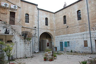
Courtyard neighborhoods are Jewish neighborhoods built in Jerusalem and Tel Aviv in the late 19th and early 20th centuries. The inward-facing and defensible traditional urban housing of the Near East, ordinarily occupied by an extended family, was adapted in these cases to serve a close-knit but genealogically unrelated community.

The following is a timeline of the history of the city of Tel Aviv, Israel.

Montefiore, Tel Aviv neighborhood in Tel Aviv

Montefiore is a neighborhood in the center of Tel Aviv, Israel.

References

  1. "בכפר – תביעות משקי השומרון מן השלטונות" [In the Village – Samaria Localities' Demands from the Authorities]. Davar (in Hebrew). November 24, 1947. Retrieved May 10, 2018.
  2. Baleslav, Yaron. "העשור הראשון להתפתחות שכונות תל אביב שמעבר לירקון, 1947–1958" [The First Decade to the Development of Tel Aviv's Neighborhoods Over the Yarkon, 1947–1958](PDF) (in Hebrew). p. 244.

Coordinates: 32°6′42.56″N34°49′44.71″E / 32.1118222°N 34.8290861°E / 32.1118222; 34.8290861

Geographic coordinate system Coordinate system

A geographic coordinate system is a coordinate system that enables every location on Earth to be specified by a set of numbers, letters or symbols. The coordinates are often chosen such that one of the numbers represents a vertical position and two or three of the numbers represent a horizontal position; alternatively, a geographic position may be expressed in a combined three-dimensional Cartesian vector. A common choice of coordinates is latitude, longitude and elevation. To specify a location on a plane requires a map projection.