
Fort William is a town in Lochaber in the Scottish Highlands, located on the eastern shore of Loch Linnhe. At the 2011 census, Fort William had a population of 10,459, making it the second-largest settlement both in the Highland council area and in the whole of the Scottish Highlands; only the city of Inverness has a larger population.

The Highlands is a historical region of Scotland. Culturally, the Highlands and the Lowlands diverged from the Late Middle Ages into the modern period, when Lowland Scots language replaced Scottish Gaelic throughout most of the Lowlands. The term is also used for the area north and west of the Highland Boundary Fault, although the exact boundaries are not clearly defined, particularly to the east. The Great Glen divides the Grampian Mountains to the southeast from the Northwest Highlands. The Scottish Gaelic name of A' Ghàidhealtachd literally means "the place of the Gaels" and traditionally, from a Gaelic-speaking point of view, includes both the Western Isles and the Highlands.

Perthshire, officially the County of Perth, is a historic county and registration county in central Scotland. Geographically it extends from Strathmore in the east, to the Pass of Drumochter in the north, Rannoch Moor and Ben Lui in the west, and Aberfoyle in the south; it borders the counties of Inverness-shire and Aberdeenshire to the north, Angus to the east, Fife, Kinross-shire, Clackmannanshire, Stirlingshire and Dunbartonshire to the south and Argyllshire to the west.
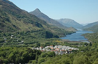
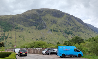
Kinlochleven is a coastal village located in Lochaber, in the Scottish Highlands and lies at the eastern end of Loch Leven. To the north lie the Mamores ridge; to the south lie the mountains flanking Glen Coe.
The A82 is a major road in Scotland that runs from Glasgow to Inverness via Fort William. It is one of the principal north-south routes in Scotland and is mostly a trunk road managed by Transport Scotland, who view it as an important link from the Central Belt to the Scottish Highlands and beyond. The road passes close to numerous landmarks, including Loch Lomond, Rannoch Moor, Glen Coe, the Ballachulish Bridge, Ben Nevis, the Commando Memorial, Loch Ness, and Urquhart Castle. Along with the A9 and the A90 it is one of the three major north–south trunk roads connecting the Central Belt to the North.
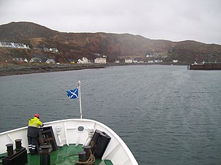
Mallaig is a port in Morar, on the west coast of the Highlands of Scotland. It faces Skye from across the Sound of Sleat. The local railway station is the terminus of the West Highland Line, and the town is linked to Fort William by the A830 road – the "Road to the Isles".
Glen Coe is a glen of volcanic origins, in the Highlands of Scotland. It lies in the north of the county of Argyll, close to the border with the historic province of Lochaber, within the modern council area of Highland. Glen Coe is regarded as the home of Scottish mountaineering and is popular with hillwalkers and climbers.

The Trossachs generally refers to an area of wooded glens, braes, and lochs lying to the east of Ben Lomond in the Stirling council area of Scotland. The name is taken from that of a small woodland glen that lies at the centre of the area, but is now generally applied to the wider region.
Glen Etive is a glen in the Scottish Highlands. The River Etive rises on the peaks surrounding Rannoch Moor, with several tributary streams coming together at the Kings House Hotel, at the head of Glen Coe. From the Kings House, the Etive flows for about 18 km, reaching the sea loch, Loch Etive. The river and its tributaries are popular with whitewater kayakers and at high water levels it is a test piece of the area and a classic run.

Drumnadrochit is a village in the Highland local government council area of Scotland, lying near the west shore of Loch Ness at the foot of Glen Urquhart. The village is close to several neighbouring settlements: the villages of Milton to the west, Kilmore to the east and Lewiston to the south. The villages act as a centre for regional tourism beside Loch Ness, as well as being a local economic hub for the nearby communities.
Carn Dearg is the name of several mountains in Scotland:
This is a list of placenames in Scotland which have subsequently been applied to parts of New Zealand by Scottish emigrants or explorers.

Loch Ness is a large freshwater loch in the Scottish Highlands extending for approximately 37 kilometres southwest of Inverness. It takes its name from the River Ness, which flows from the northern end. Loch Ness is best known for claimed sightings of the cryptozoological Loch Ness Monster, also known affectionately as "Nessie". It is one of a series of interconnected, murky bodies of water in Scotland; its water visibility is exceptionally low due to the high peat content of the surrounding soil. The southern end connects to Loch Oich by the River Oich and a section of the Caledonian Canal. The northern end connects to Loch Dochfour via the River Ness, which then ultimately leads to the North Sea via the Moray Firth.
The Lochaber hydroelectric scheme is a hydroelectric power generation project constructed in the Lochaber area of the western Scottish Highlands after the First World War. Like its predecessors at Kinlochleven and Foyers, it was designed to provide electricity for aluminium production, this time at Fort William.

The River Nevis flows from the mountains east of Ben Nevis to its mouth near the town of Fort William in Scotland.

Loch Loyne is a loch in the Northwest Highlands of Scotland. Loch Loyne lies between Glen Garry and Glen Cluanie. The A87 road runs beside the eastern side of the loch.

Ben Nevis and Glen Coe is a national scenic area (NSA) covering part of the Highlands of Scotland surrounding Ben Nevis and Glen Coe, in which certain forms of development are restricted. It is one of 40 such areas in Scotland, which are defined so as to identify areas of exceptional scenery and to ensure its protection from inappropriate development. The Ben Nevis and Glen Coe NSA covers 903 km2 (349 sq mi) of land, lying within the Highland, Argyll and Bute and Perth and Kinross council areas. A further 19 km2 (7.3 sq mi) of the NSA are marine, covering the sea loch of Loch Leven.

The Loch Rannoch and Glen Lyon National Scenic Area is a national scenic area (NSA) covering the area surrounding Loch Rannoch, Glen Lyon, and the Ben Lawers ranges of mountains in Scotland. It is one of 40 such areas in Scotland, which are defined so as to identify areas of exceptional scenery and to ensure its protection from inappropriate development by restricting certain forms of development. The Loch Rannoch and Glen Lyon NSA covers 48,625 ha, most of which lies in the council area of Perth and Kinross, with a small portion lying in Stirling.

The geology of the Isle of Mull in Scotland is dominated by the development during the early Palaeogene period of a ‘volcanic central complex’ associated with the opening of the Atlantic Ocean. The bedrock of the larger part of the island is formed by basalt lava flows ascribed to the Mull Lava Group erupted onto a succession of Mesozoic sedimentary rocks during the Palaeocene epoch. Precambrian and Palaeozoic rocks occur at the island's margins. A number of distinct deposits and features such as raised beaches were formed during the Quaternary period.
The Meall an t-Suidhe is a mountain in Scotland, located close to the Ben Nevis.