The Boston and Maine Railroad was a U.S. Class I railroad in northern New England. Originally chartered in 1835, it became part of what was the Pan Am Railways network in 1983.

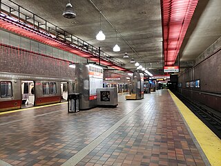
South Station, officially The Governor Michael S. Dukakis Transportation Center at South Station, is the largest railroad station and intercity bus terminal in Greater Boston and New England's second-largest transportation center after Logan International Airport. Located at the intersection of Atlantic Avenue and Summer Street in Dewey Square, Boston, Massachusetts, the historic station building was constructed in 1899 to replace the downtown terminals of several railroads. Today, it serves as a major intermodal domestic transportation hub, with service to the Greater Boston region and the Northeastern and Midwestern United States. It is used by thousands of commuter rail and intercity rail passengers daily. Connections to the rapid transit Red Line and bus rapid transit Silver Line are made through the adjacent subway station.
Alewife station is a Massachusetts Bay Transportation Authority (MBTA) intermodal transit station in the North Cambridge neighborhood of Cambridge, Massachusetts. It is the northwest terminal of the rapid transit Red Line and a hub for several MBTA bus routes. The station is at the confluence of the Minuteman Bikeway, Alewife Linear Park, Fitchburg Cutoff Path, and Alewife Greenway off Alewife Brook Parkway adjacent to Massachusetts Route 2, with a five-story parking garage for park and ride use. The station has three bike cages. Alewife station is named after nearby Alewife Brook Parkway and Alewife Brook, themselves named after the alewife fish.

The MBTA Commuter Rail system serves as the commuter rail arm of the Massachusetts Bay Transportation Authority's (MBTA's) transportation coverage of Greater Boston in the United States. Trains run over 394 mi (634 km) of track to 134 stations. It is operated under contract by Keolis, which took over operations on July 1, 2014, from the Massachusetts Bay Commuter Railroad Company (MBCR).

The North–South Rail Link (NSRL) is a proposed rail tunnel, or pair of tunnels, that would connect North Station and South Station in downtown Boston, Massachusetts. The project would build new underground stations near the existing stations, connect them with about 1.5 miles (2.4 km) of tunnels, and add other tunnels to link up with existing surface tracks.

The Boston and Albany Railroad was a railroad connecting Boston, Massachusetts to Albany, New York, later becoming part of the New York Central Railroad system, Conrail, and CSX Transportation. The line is currently used by CSX for freight. Passenger service is provided on the line by Amtrak, as part of their Lake Shore Limited service, and by the MBTA Commuter Rail system, which owns the section east of Worcester and operates it as its Framingham/Worcester Line.

Lechmere station is a Massachusetts Bay Transportation Authority (MBTA) Green Line light rail station in Lechmere Square in East Cambridge, Massachusetts. It is located on the east side of Monsignor O'Brien Highway near First Street, adjacent to the NorthPoint development. The accessible elevated station has a single island platform, with headhouses at both ends. It opened on March 21, 2022, as part of the Green Line Extension (GLX). Lechmere station is served by Green Line D branch and E branch service.
The Grand Junction Railroad is an 8.55-mile (13.76 km) long railroad in the Boston, Massachusetts, area, connecting the railroads heading west and north from Boston. Most of it is still in use, carrying scrap either inbound or outbound to the Schnitzer scrap yard on the Everett waterfront or freight to the Chelsea Produce Market, and non-revenue transfers of Amtrak and MBTA passenger equipment between the lines terminating at North Station and South Station. The line is also notable for its railroad bridge over the Charles River that passes under the Boston University Bridge between Boston and Cambridge, Massachusetts.

The Green Line D branch is a light rail line in Boston, Brookline, Cambridge, Newton, and Somerville, Massachusetts, operating as part of the Massachusetts Bay Transportation Authority (MBTA) Green Line. The line runs on a grade separated surface right-of-way for 9 miles (14 km) from Riverside station to Fenway station. The line merges into the C branch tunnel west of Kenmore, then follows the Boylston Street subway and Tremont Street subway to North Station. It is the longest and busiest of the four Green Line branches. As of February 2022, service operates on 7-minute headways at weekday peak hours and 8 to 11-minute headways at other times, using 11 to 17 trains.

The Boston and Providence Railroad was a railroad company in the states of Massachusetts and Rhode Island which connected its namesake cities. It opened in two sections in 1834 and 1835 - one of the first rail lines in the United States - with a more direct route into Providence built in 1847. Branches were built to Dedham in 1834, Stoughton in 1845, and North Attleboro in 1871. It was acquired by the Old Colony Railroad in 1888, which in turn was leased by the New Haven Railroad in 1893. The line became the New Haven's primary mainline to Boston; it was realigned in Boston in 1899 during the construction of South Station, and in Pawtucket and Central Falls in 1916 for grade crossing elimination.
The Urban Ring was a proposed project of the Massachusetts Bay Transportation Authority and the Massachusetts Department of Transportation, to develop new public transportation routes that would provide improved circumferential connections among many existing transit lines that project radially from downtown Boston. The Urban Ring Corridor is located roughly one to two miles from downtown Boston, passing through the Massachusetts cities of Boston, Chelsea, Everett, Medford, Somerville, Cambridge, and Brookline. The project was expected to convert 41,500 car trips to transit trips daily.

Revere Beach station is a rapid transit station in Revere, Massachusetts. Located between Beach Street and Shirley Avenue, it serves the MBTA Blue Line. It serves Revere Beach, a popular summer destination with a substantial year-round resident population. It opened in January 1954 on the site of a former Boston, Revere Beach and Lynn Railroad station, as part of an extension to Wonderland. Revere Beach station was closed and rebuilt from 1994 to 1995.

The Fitchburg Cutoff was a rail line running 2.8 miles (4.5 km) from Brighton Street in Belmont, Massachusetts, to Somerville Junction in Somerville, Massachusetts. It was constructed in two segments in 1870 and 1881 to connect the Lexington Branch and Central Massachusetts Railroad to the Boston and Lowell Railroad. Passenger service lasted until 1927. Freight service ended in 1979–80 to allow construction of the Red Line Northwest Extension; the line was abandoned in three sections in 1979, 1983, and 2007.

Lowell station, officially the Charles A. Gallagher Transit Terminal, is an intermodal transit station in Lowell, Massachusetts. The transit complex includes an MBTA Commuter Rail station as well as the Robert B. Kennedy Bus Transfer Center, which serves local and intercity buses. It is located off Thorndike Street near the end of the Lowell Connector south of downtown Lowell. The commuter rail station is the northern terminus of the Lowell Line, and is a major park-and-ride station for the system, serving commuters from Lowell, northern Massachusetts, and southern New Hampshire. The Kennedy Bus Transfer Center is the transfer point for all Lowell Regional Transit Authority local bus routes and several intercity bus routes by other operators.

Bellingham Square station is a Massachusetts Bay Transportation Authority (MBTA) Silver Line bus rapid transit (BRT) station located near Bellingham Square slightly north of downtown Chelsea, Massachusetts. The station has two accessible side platforms for buses on the SL3 route. The Boston and Maine Railroad and predecessor Eastern Railroad served Chelsea station at the same location from the mid-1850s to 1958. The MBTA opened Chelsea station on the Newburyport/Rockport Line in 1985. Prior to its 2010 cancellation, the Urban Ring Project planned for a circumferential BRT line with a stop at Mystic Mall. Planning continued for the Chelsea segment; a Silver Line extension to Mystic Mall was announced in 2013. Construction began in 2015, and SL3 service to the renamed Bellingham Square station began on April 21, 2018. Commuter rail service moved to the newly constructed Chelsea station on November 15, 2021.

Medford/Tufts station is a light rail station on the Massachusetts Bay Transportation Authority (MBTA) Green Line located off Boston Avenue near College Avenue in Medford, Massachusetts, adjacent to Tufts University. The accessible station has a single island platform serving the two tracks of the Medford Branch. It opened on December 12, 2022, as part of the Green Line Extension (GLX), which added two northern branches to the Green Line, and is the northern terminus of the E branch.

Ball Square station is a light rail station on the Massachusetts Bay Transportation Authority (MBTA) Green Line located at Ball Square in Somerville and Medford, Massachusetts. The accessible station has a single island platform serving the two tracks of the Medford Branch. It opened on December 12, 2022, as part of the Green Line Extension (GLX), which added two northern branches to the Green Line, and is served by the E branch.
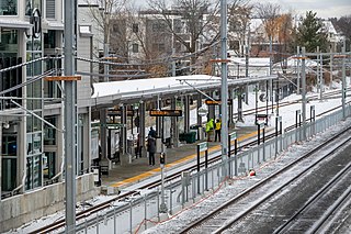
Magoun Square station is a light rail station on the Massachusetts Bay Transportation Authority (MBTA) Green Line located at Lowell Street south of Magoun Square in Somerville, Massachusetts. The accessible station has a single island platform serving the two tracks of the Medford Branch. It opened on December 12, 2022, as part of the Green Line Extension (GLX), which added two northern branches to the Green Line, and is served by the E branch.

Gilman Square station is a light rail station on the Massachusetts Bay Transportation Authority (MBTA) Green Line located at Gilman Square in Somerville, Massachusetts. The accessible station has a single island platform serving the two tracks of the Medford Branch. It opened on December 12, 2022, as part of the Green Line Extension (GLX), which added two northern branches to the Green Line, and is served by the E branch.

East Somerville station is a light rail station on the Massachusetts Bay Transportation Authority (MBTA) Green Line located in southeastern Somerville, Massachusetts. The accessible station has a single island platform serving the two tracks of the Medford Branch. It opened on December 12, 2022, as part of the Green Line Extension (GLX), which added two northern branches to the Green Line, and is served by the E branch.
